
Topografische Karte Durgam Cheruvu Secret Lake Park
Interaktive Karte
Klicken Sie auf die Karte, um die Höhe anzuzeigen.
Über diese Karte
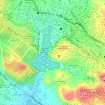
Name: Topografische Karte Durgam Cheruvu Secret Lake Park, Höhe, Relief.
Durchschnittliche Höhe: 579 m
Minimale Höhe: 540 m
Maximale Höhe: 629 m
Andere topografische Karten
Klicken Sie auf eine Karte, um ihre Topografie, ihre Höhe und ihr Relief anzuzeigen.
Gopanpally Tank
India > Telangana > Serilingampalle mandal > Hyderabad
Gopanpally Tank, Ward 105 Gachibowli, Greater Hyderabad Municipal Corporation West Zone, Hyderabad, Serilingampalle mandal, Ranga Reddy District, Telangana, India
Durchschnittliche Höhe: 577 m
Durgam Cheruvu
India > Telangana > Serilingampalle mandal > Hyderabad
Durgam Cheruvu, Durgam Cheruvu Road, Madhapur, Ward 104 Kondapur, Greater Hyderabad Municipal Corporation West Zone, Hyderabad, Serilingampalle mandal, Ranga Reddy District, Telangana, 996544, India
Durchschnittliche Höhe: 577 m
Patel Cheruvu
India > Telangana > Serilingampalle mandal > Hyderabad
Patel Cheruvu, Ward 108 Miyapur, Hyderabad, Serilingampalle mandal, Rangareddy, Telangana, India
Durchschnittliche Höhe: 577 m