
Topografische Karte Central Park
Interaktive Karte
Klicken Sie auf die Karte, um die Höhe anzuzeigen.
Über diese Karte
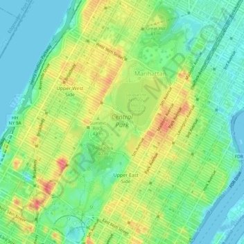
Name: Topografische Karte Central Park, Höhe, Relief.
Ort: Central Park, New York County, New York, United States (40.76475 -73.98141 40.80031 -73.94961)
Durchschnittliche Höhe: 26 m
Minimale Höhe: -5 m
Maximale Höhe: 65 m
In June 1856, Fernando Wood appointed a "consulting board" of seven people, headed by author Washington Irving, to inspire public confidence in the proposed development.[65][66] Wood hired military engineer Egbert Ludovicus Viele as the park's chief engineer, tasking him with a topographical survey of the site.[67][68][69] The following April, the state legislature passed a bill to authorize the appointment of four Democratic and seven Republican commissioners,[65][70] who had exclusive control over the planning and construction process.[71][72][73] Though Viele had already devised a plan for the park,[74] the commissioners disregarded it and retained him to complete only the topographical surveys.[75][76] The Central Park Commission began hosting a landscape design contest shortly after its creation.[76][77][78] The commission specified that each entry contain extremely detailed specifications, as mandated by the consulting board.[78][79][80] Thirty-three firms or organizations submitted plans.[78][79]
Andere topografische Karten
Klicken Sie auf eine Karte, um ihre Topografie, ihre Höhe und ihr Relief anzuzeigen.
Sequoia Tree
United States > New York > New York County > New York
Sequoia Tree, Morningside Avenue, Manhattan Community Board 9, Manhattan, New York County, New York, 10027, United States
Durchschnittliche Höhe: 19 m
Manhattan
United States > New York > New York County > New York
Manhattan, New York County, New York, United States
Durchschnittliche Höhe: 16 m
Roosevelt Island
United States > New York > New York County > New York
Roosevelt Island, Manhattan, New York County, New York, 10044, United States
Durchschnittliche Höhe: 13 m