
Topografische Karte Hardin County
Interaktive Karte
Klicken Sie auf die Karte, um die Höhe anzuzeigen.
Über diese Karte
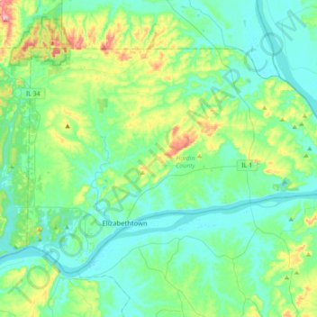
Name: Topografische Karte Hardin County, Höhe, Relief.
Ort: Hardin County, Illinois, USA (37.40166 -88.41388 37.60309 -88.06257)
Durchschnittliche Höhe: 140 m
Minimale Höhe: 97 m
Maximale Höhe: 302 m
Andere topografische Karten
Klicken Sie auf eine Karte, um ihre Topografie, ihre Höhe und ihr Relief anzuzeigen.
Northbrook
USA > Illinois > Northbrook
Northbrook, Cook County, Illinois, 60062, USA
Durchschnittliche Höhe: 201 m
Pearl Island
Pearl Island, Pike County, Illinois, 63401, USA
Durchschnittliche Höhe: 193 m
Douglas Park
USA > Illinois > Douglas Park
Douglas Park, Whiteside County, Illinois, 61037, USA
Durchschnittliche Höhe: 197 m
Garfield Ridge
Garfield Ridge, Chicago, Cook County, Illinois, USA
Durchschnittliche Höhe: 184 m
Montague Island
Montague Island, Rockford, Winnebago County, Illinois, 61104, USA
Durchschnittliche Höhe: 254 m