
Spenden
Rüste dich für dein nächstes Abenteuer:
Als Amazon-Partner verdient diese Seite an qualifizierten Käufen, ohne dass Ihnen zusätzliche Kosten entstehen.
Topografische Karte Virgin
Klicken Sie auf die Karte, um die Höhe anzuzeigen.
Spenden
Rüste dich für dein nächstes Abenteuer:
Als Amazon-Partner verdient diese Seite an qualifizierten Käufen, ohne dass Ihnen zusätzliche Kosten entstehen.
Virgin
Laut dem United States Census Bureau erstreckt sich Virgin auf einer Fläche von 11,9 Quadratmeilen (30,9 km²) auf einer Höhe von etwa 3606 Fuß (1099 m). Im Nordwesten der Stadt befindet sich der Hurricane Mesa Test Facility, ein mittlerweile nur noch privat genutzter ehemaliger Test-Flugplatz der US Air Force.
Spenden
Rüste dich für dein nächstes Abenteuer:
Als Amazon-Partner verdient diese Seite an qualifizierten Käufen, ohne dass Ihnen zusätzliche Kosten entstehen.
Über diese Karte
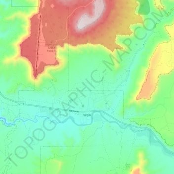
Name: Topografische Karte Virgin, Höhe, Relief.
Durchschnittliche Höhe: 1’251 m
Minimale Höhe: 1’003 m
Maximale Höhe: 1’758 m
Spenden
Rüste dich für dein nächstes Abenteuer:
Als Amazon-Partner verdient diese Seite an qualifizierten Käufen, ohne dass Ihnen zusätzliche Kosten entstehen.
Andere topografische Karten
Klicken Sie auf eine Karte, um ihre Topografie, ihre Höhe und ihr Relief anzuzeigen.
Angels Landing
Vereinigte Staaten von Amerika > Utah > Washington County
Zion Canyon und Angels Landing sind Teil der Grand Staircase, die sich in den vergangenen Millionen Jahren in den ungefalteten, überwiegend mesozoischen Sedimentgesteinen des Colorado-Plateaus ausgeformt hat. Angels Landing ist ein gedrungener Felsenturm mit nahezu vertikalen Flanken, der aus porösem und…
Durchschnittliche Höhe: 1’695 m