
Spenden
Rüste dich für dein nächstes Abenteuer:
Als Amazon-Partner verdient diese Seite an qualifizierten Käufen, ohne dass Ihnen zusätzliche Kosten entstehen.
Topografische Karte Connecticut
Klicken Sie auf die Karte, um die Höhe anzuzeigen.
Spenden
Rüste dich für dein nächstes Abenteuer:
Als Amazon-Partner verdient diese Seite an qualifizierten Käufen, ohne dass Ihnen zusätzliche Kosten entstehen.
Über diese Karte
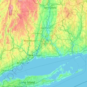
Name: Topografische Karte Connecticut, Höhe, Relief.
Ort: Connecticut, Vereinigte Staaten von Amerika (40.95098 -73.72781 42.05058 -71.78724)
Durchschnittliche Höhe: 118 m
Minimale Höhe: -3 m
Maximale Höhe: 780 m
Spenden
Rüste dich für dein nächstes Abenteuer:
Als Amazon-Partner verdient diese Seite an qualifizierten Käufen, ohne dass Ihnen zusätzliche Kosten entstehen.
Andere topografische Karten
Klicken Sie auf eine Karte, um ihre Topografie, ihre Höhe und ihr Relief anzuzeigen.
Mauna Kea
Vereinigte Staaten von Amerika > Hawaii > Hawaii
Der Vulkan Mauna Kea (hawaiisch für Weißer Berg oder Mauna a Wākea) ist mit etwa 4205 m der höchste Berg auf Hawaii. Bezieht man bei der Messung der Höhe den unterhalb der Meeresoberfläche liegenden Anteil mit ein, gilt der Mauna Kea mit 10.203 Metern als höchster Berg der Erde. Mauna Kea wird in der…
Durchschnittliche Höhe: 3’978 m
Central Park
Vereinigte Staaten von Amerika > New York > New York County > New York
In den ersten fünf Jahren hatten die Arbeiter fast 2,5 Millionen yd3 (1,9 Millionen Kubikmeter) Steine und Erde bewegt – genug, um ein Fußballfeld um acht Stockwerke zu erhöhen. Mit Spitzhacken, Hämmern und Schaufeln und 166 t Schießpulver sprengten sie 300.000 yd3 Felsgestein aus Gneis, durchzogen von…
Durchschnittliche Höhe: 26 m
Wrangell Mountains
Vereinigte Staaten von Amerika > Alaska > Unorganized Borough
Durchschnittliche Höhe: 2’297 m
Rocky Mountains
Vereinigte Staaten von Amerika > Wyoming > Teton County
Die Vegetation der Rocky Mountains lässt sich in mehrere Höhenstufen unterteilen. Außer in den borealen Bereichen Kanadas, wo die von Fichten dominierten nordischen Nadelwälder der Ebenen in Bergwälder aus Fichten und Kiefern übergehen, sind die großflächigen unteren montanen Bereiche der Rockies im…
Durchschnittliche Höhe: 2’292 m
Spenden
Rüste dich für dein nächstes Abenteuer:
Als Amazon-Partner verdient diese Seite an qualifizierten Käufen, ohne dass Ihnen zusätzliche Kosten entstehen.
Appalachen
Vereinigte Staaten von Amerika > Nord-Carolina > Yancey County
Die Appalachen (englisch Appalachian Mountains, französisch Appalaches) sind ein bewaldetes Gebirgssystem im Osten Nordamerikas, das sich (geologisch betrachtet) über eine Länge von 2400 Kilometern von den Long Range Mountains an der Westküste der kanadischen Insel Neufundland bis in den Norden des…
Durchschnittliche Höhe: 1’463 m
Spenden
Rüste dich für dein nächstes Abenteuer:
Als Amazon-Partner verdient diese Seite an qualifizierten Käufen, ohne dass Ihnen zusätzliche Kosten entstehen.
Pierce Stocking Scenic Drive
Vereinigte Staaten von Amerika > Michigan > Leelanau County > Empire Township
Durchschnittliche Höhe: 227 m
Spenden
Rüste dich für dein nächstes Abenteuer:
Als Amazon-Partner verdient diese Seite an qualifizierten Käufen, ohne dass Ihnen zusätzliche Kosten entstehen.
Jersey Island
Vereinigte Staaten von Amerika > Kalifornien > Contra Costa County
Durchschnittliche Höhe: 59 m
Burtis Bay
Vereinigte Staaten von Amerika > New York > Chautauqua County > Town of Busti
Durchschnittliche Höhe: 409 m
Spenden
Rüste dich für dein nächstes Abenteuer:
Als Amazon-Partner verdient diese Seite an qualifizierten Käufen, ohne dass Ihnen zusätzliche Kosten entstehen.
Patchen (historic)
Vereinigte Staaten von Amerika > Kalifornien > Santa Clara County
Durchschnittliche Höhe: 459 m
Greenwood
Vereinigte Staaten von Amerika > Kentucky > Jefferson County > Louisville
Durchschnittliche Höhe: 153 m
Isaar
Vereinigte Staaten von Amerika > Wisconsin > Outagamie County > Town of Seymour
Durchschnittliche Höhe: 253 m
Spenden
Rüste dich für dein nächstes Abenteuer:
Als Amazon-Partner verdient diese Seite an qualifizierten Käufen, ohne dass Ihnen zusätzliche Kosten entstehen.
Lakeview
Vereinigte Staaten von Amerika > Louisiana > Orleans Parish > New Orleans
Durchschnittliche Höhe: 2 m
Elizabeth Street Garden
Vereinigte Staaten von Amerika > New York > New York County > New York
Durchschnittliche Höhe: 15 m
Spenden
Rüste dich für dein nächstes Abenteuer:
Als Amazon-Partner verdient diese Seite an qualifizierten Käufen, ohne dass Ihnen zusätzliche Kosten entstehen.
Gertrude
Vereinigte Staaten von Amerika > Arkansas > Miller County > Texarkana
Durchschnittliche Höhe: 120 m
Black Creek Village
Vereinigte Staaten von Amerika > New York > Niagara County > City of Niagara Falls
Durchschnittliche Höhe: 176 m
Great Plains
Vereinigte Staaten von Amerika > Kansas > Thomas County
Die Ostgrenze wird unterschiedlich definiert. Manche Geografen verbinden sämtliche Ränder der Ebene, die auf 600 m Höhe liegen, und definieren die so entstandene Linie als Ostgrenze, wie in der grün schraffierten obigen Grafik. Andere ziehen die Grenze, entsprechend der Verbreitung der Hochgrasprärie,…
Durchschnittliche Höhe: 1’023 m
Spenden
Rüste dich für dein nächstes Abenteuer:
Als Amazon-Partner verdient diese Seite an qualifizierten Käufen, ohne dass Ihnen zusätzliche Kosten entstehen.
Rocky Mountain National Park
Vereinigte Staaten von Amerika > Colorado
Durchschnittliche Höhe: 3’448 m
Grand Canyon
Vereinigte Staaten von Amerika > Arizona > Coconino County
Das Gebiet um das Tal wird in drei Regionen aufgeteilt: den Südrand (South Rim), der die meisten Besucher anzieht, den im Durchschnitt ca. 300 m höher gelegenen und kühleren Nordrand (North Rim) und die Innere Schlucht (Inner Canyon). Der Südrand des Grand Canyons liegt im Durchschnitt auf 2100 m ü. M.,…
Durchschnittliche Höhe: 1’023 m
Spenden
Rüste dich für dein nächstes Abenteuer:
Als Amazon-Partner verdient diese Seite an qualifizierten Käufen, ohne dass Ihnen zusätzliche Kosten entstehen.
Rummel
Vereinigte Staaten von Amerika > Pennsylvania > Somerset County > Paint Township
Durchschnittliche Höhe: 600 m
Osprey
Vereinigte Staaten von Amerika > Florida > Sarasota County > Osprey
Durchschnittliche Höhe: 3 m
Dieffenbach
Vereinigte Staaten von Amerika > Pennsylvania > Montour County > Derry Township
Durchschnittliche Höhe: 172 m
Bay Port Colony
Vereinigte Staaten von Amerika > Florida > Hillsborough County
Durchschnittliche Höhe: 4 m
Spenden
Rüste dich für dein nächstes Abenteuer:
Als Amazon-Partner verdient diese Seite an qualifizierten Käufen, ohne dass Ihnen zusätzliche Kosten entstehen.
Knollwood
Vereinigte Staaten von Amerika > Süd-Carolina > Greenville County > Greenville
Durchschnittliche Höhe: 283 m
Spenden
Rüste dich für dein nächstes Abenteuer:
Als Amazon-Partner verdient diese Seite an qualifizierten Käufen, ohne dass Ihnen zusätzliche Kosten entstehen.
Newmans Pond
Vereinigte Staaten von Amerika > Georgia > Troup County > LaGrange
Durchschnittliche Höhe: 220 m
Four Mile
Vereinigte Staaten von Amerika > Mississippi > Humphreys County
Durchschnittliche Höhe: 33 m
Monument Valley Navajo Tribal Park
Vereinigte Staaten von Amerika > Arizona > Navajo County
Das Monument Valley liegt in der Four-Corners-Region, an der Grenze zwischen Arizona und Utah, westlich der Staatsgrenzen zu Colorado und New Mexico in einer Höhe von fast 1900 m und wird bevölkerungsstatistisch in die beiden Schwestergebiete Oljato, Arizona und Oljato, Utah geteilt. Die Temperaturen im…
Durchschnittliche Höhe: 1’675 m
Spenden
Rüste dich für dein nächstes Abenteuer:
Als Amazon-Partner verdient diese Seite an qualifizierten Käufen, ohne dass Ihnen zusätzliche Kosten entstehen.
Orchard Garden
Vereinigte Staaten von Amerika > Minnesota > Dakota County > Burnsville
Durchschnittliche Höhe: 303 m
Wiscon
Vereinigte Staaten von Amerika > Florida > Hernando County > Brooksville
Durchschnittliche Höhe: 30 m
Glenwood Hills
Vereinigte Staaten von Amerika > Neumexiko > Bernalillo County > Albuquerque
Durchschnittliche Höhe: 1’937 m
Red Rock / Tsé Łichííʼ Dah Azkání
Vereinigte Staaten von Amerika > Arizona > Apache County
Durchschnittliche Höhe: 1’780 m
Spenden
Rüste dich für dein nächstes Abenteuer:
Als Amazon-Partner verdient diese Seite an qualifizierten Käufen, ohne dass Ihnen zusätzliche Kosten entstehen.
Grant Grove Village
Vereinigte Staaten von Amerika > Kalifornien > Tulare County
Durchschnittliche Höhe: 2’015 m
Denali
Vereinigte Staaten von Amerika > Alaska > Denali Borough
Der Denali oder Mount McKinley in Alaska ist mit 6190 Metern Höhe der höchste Berg Nordamerikas. Er ist damit einer der Seven Summits, der jeweils höchsten Berge der sieben Kontinente.
Durchschnittliche Höhe: 5’546 m
Spenden
Rüste dich für dein nächstes Abenteuer:
Als Amazon-Partner verdient diese Seite an qualifizierten Käufen, ohne dass Ihnen zusätzliche Kosten entstehen.
Arbor
Vereinigte Staaten von Amerika > Kalifornien > Contra Costa County > Brentwood
Durchschnittliche Höhe: 29 m
Spenden
Rüste dich für dein nächstes Abenteuer:
Als Amazon-Partner verdient diese Seite an qualifizierten Käufen, ohne dass Ihnen zusätzliche Kosten entstehen.
Sierra Nevada
Vereinigte Staaten von Amerika > Kalifornien > Tulare County
Durchschnittliche Höhe: 3’888 m
Saint Ann
Vereinigte Staaten von Amerika > Missouri > Saint Louis County > St. Ann
Durchschnittliche Höhe: 183 m
Spenden
Rüste dich für dein nächstes Abenteuer:
Als Amazon-Partner verdient diese Seite an qualifizierten Käufen, ohne dass Ihnen zusätzliche Kosten entstehen.
Mammoth Lake
Vereinigte Staaten von Amerika > Texas > Brazoria County > Clute
Durchschnittliche Höhe: 7 m
Island Retreat
Vereinigte Staaten von Amerika > Georgia > Glynn County > St. Simons
Durchschnittliche Höhe: 5 m
New York
Vereinigte Staaten von Amerika > New York
Manhattan steht auf Felsgrund, der es ermöglicht, auch höhere Bauwerke zu errichten. Es ist von zahlreichen Naturhäfen umgeben, die durch Schiffe mit großem Tiefgang angelaufen werden können. Der Hudson öffnet den wichtigsten natürlichen Weg ins Hinterland und ermöglicht es, über den Mohawk River bzw.…
Durchschnittliche Höhe: 15 m
Twistal Swamp
Vereinigte Staaten von Amerika > Minnesota > Kittson County
Durchschnittliche Höhe: 320 m
Spenden
Rüste dich für dein nächstes Abenteuer:
Als Amazon-Partner verdient diese Seite an qualifizierten Käufen, ohne dass Ihnen zusätzliche Kosten entstehen.
Antelope Canyon
Vereinigte Staaten von Amerika > Arizona > Coconino County
Durchschnittliche Höhe: 1’205 m
Double Dips Crossing
Vereinigte Staaten von Amerika > Oklahoma > Comanche County
Durchschnittliche Höhe: 408 m
Divide Creek
Vereinigte Staaten von Amerika > Montana > Glacier County
Durchschnittliche Höhe: 2’208 m
Spenden
Rüste dich für dein nächstes Abenteuer:
Als Amazon-Partner verdient diese Seite an qualifizierten Käufen, ohne dass Ihnen zusätzliche Kosten entstehen.
Alva, Oklahoma 73717
Vereinigte Staaten von Amerika > Oklahoma > Woods County > Alva
Durchschnittliche Höhe: 417 m
Silicon Valley
Vereinigte Staaten von Amerika > Kalifornien > Santa Clara County > Palo Alto
Durchschnittliche Höhe: 118 m
Mount Shasta
Vereinigte Staaten von Amerika > Kalifornien > Siskiyou County
Der Mount Shasta (in der Karok-Sprache: „Úytaahkoo“, dt. „Weißer Berg“) ist ein Stratovulkan im Norden des US-Bundesstaats Kalifornien. Der gleichnamige Ort Mount Shasta mit etwa 3000 Einwohnern liegt am Fuß des Berges auf 1100 Metern Seehöhe.
Durchschnittliche Höhe: 3’717 m
Spenden
Rüste dich für dein nächstes Abenteuer:
Als Amazon-Partner verdient diese Seite an qualifizierten Käufen, ohne dass Ihnen zusätzliche Kosten entstehen.
Mount Whitney
Vereinigte Staaten von Amerika > Kalifornien > Tulare County
Der Mount Whitney (in der Sprache der Paiute Tumanguya) ist ein 4419 m hoher Berg in Kalifornien und der höchste Berg der USA außerhalb Alaskas. Innerhalb der gesamten USA ist mit 6190 m Höhe der Denali (Mount McKinley) in Alaska der höchste Berg.
Durchschnittliche Höhe: 3’903 m
Spenden
Rüste dich für dein nächstes Abenteuer:
Als Amazon-Partner verdient diese Seite an qualifizierten Käufen, ohne dass Ihnen zusätzliche Kosten entstehen.
Lower Falls
Vereinigte Staaten von Amerika > West Virginia > Kanawha County
Durchschnittliche Höhe: 215 m
Spenden
Rüste dich für dein nächstes Abenteuer:
Als Amazon-Partner verdient diese Seite an qualifizierten Käufen, ohne dass Ihnen zusätzliche Kosten entstehen.
Serrano Place
Vereinigte Staaten von Amerika > Kalifornien > Orange County > Lake Forest
Durchschnittliche Höhe: 157 m
The Flatirons
Vereinigte Staaten von Amerika > Colorado > Boulder County
Durchschnittliche Höhe: 2’051 m
Mammoth
Vereinigte Staaten von Amerika > Pennsylvania > Westmoreland County > Mount Pleasant Township
Durchschnittliche Höhe: 357 m
Spenden
Rüste dich für dein nächstes Abenteuer:
Als Amazon-Partner verdient diese Seite an qualifizierten Käufen, ohne dass Ihnen zusätzliche Kosten entstehen.
Cumberland Gap
Vereinigte Staaten von Amerika > Virginia > Lee County
Cumberland Gap ist der Name eines auf 488 Meter Höhe gelegenen Gebirgspasses in den Cumberland Mountains, einer Bergkette der Appalachen. Berühmt wurde er im 18. und 19. Jahrhundert als Hauptweg der weißen Siedler ins Landesinnere Nordamerikas. Der Pass war Teil der Wilderness Road, einem ehemaligen…
Durchschnittliche Höhe: 512 m
Clearco
Vereinigte Staaten von Amerika > West Virginia > Greenbrier County
Durchschnittliche Höhe: 1’129 m
Spenden
Rüste dich für dein nächstes Abenteuer:
Als Amazon-Partner verdient diese Seite an qualifizierten Käufen, ohne dass Ihnen zusätzliche Kosten entstehen.
Mount Elbert
Vereinigte Staaten von Amerika > Colorado > Lake County
Im Vergleich zu anderen Bergen ähnlicher Höhe besitzt der Mount Elbert wenige Firnfelder, was darauf zurückzuführen ist, dass der Berg aufgrund seiner Lage und Form eine weniger effektive Wetterbarriere darstellt als umliegende Gebirgszüge und dadurch die Niederschlagsmenge geringer ist.
Durchschnittliche Höhe: 3’959 m
North Fairhaven
Vereinigte Staaten von Amerika > Massachusetts > Bristol County > Fairhaven
Durchschnittliche Höhe: 11 m
Spenden
Rüste dich für dein nächstes Abenteuer:
Als Amazon-Partner verdient diese Seite an qualifizierten Käufen, ohne dass Ihnen zusätzliche Kosten entstehen.
Talbert
Vereinigte Staaten von Amerika > Kalifornien > Orange County > Fountain Valley
Durchschnittliche Höhe: 10 m
Prarie
Vereinigte Staaten von Amerika > Iowa > Linn County > Cedar Rapids
Durchschnittliche Höhe: 252 m
Bruns
Vereinigte Staaten von Amerika > Louisiana > Iberville Parish > St. Gabriel
Durchschnittliche Höhe: 6 m
Spenden
Rüste dich für dein nächstes Abenteuer:
Als Amazon-Partner verdient diese Seite an qualifizierten Käufen, ohne dass Ihnen zusätzliche Kosten entstehen.
Mount Rainier
Vereinigte Staaten von Amerika > Washington > Pierce County
Der Mount Rainier ist ein etwa 500.000 bis 1 Million Jahre alter Schichtvulkan. Durch sein enormes Wachstum auf eine Höhe von über 4300 Meter vergletscherte seine Spitze. Während der letzten 65.000 Jahre hat der Mount Rainier mindestens drei ausgedehnte Perioden der Vergletscherung durchgemacht. Die letzte…
Durchschnittliche Höhe: 3’912 m
Spenden
Rüste dich für dein nächstes Abenteuer:
Als Amazon-Partner verdient diese Seite an qualifizierten Käufen, ohne dass Ihnen zusätzliche Kosten entstehen.