
Spenden
Rüste dich für dein nächstes Abenteuer:
Als Amazon-Partner verdient diese Seite an qualifizierten Käufen, ohne dass Ihnen zusätzliche Kosten entstehen.
Topografische Karte Utah
Klicken Sie auf die Karte, um die Höhe anzuzeigen.
Spenden
Rüste dich für dein nächstes Abenteuer:
Als Amazon-Partner verdient diese Seite an qualifizierten Käufen, ohne dass Ihnen zusätzliche Kosten entstehen.
Über diese Karte
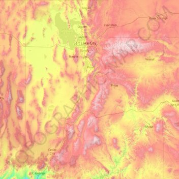
Name: Topografische Karte Utah, Höhe, Relief.
Ort: Utah, Vereinigte Staaten von Amerika (36.99781 -114.05285 42.00170 -109.04158)
Durchschnittliche Höhe: 1’876 m
Minimale Höhe: 789 m
Maximale Höhe: 3’986 m
Spenden
Rüste dich für dein nächstes Abenteuer:
Als Amazon-Partner verdient diese Seite an qualifizierten Käufen, ohne dass Ihnen zusätzliche Kosten entstehen.
Andere topografische Karten
Klicken Sie auf eine Karte, um ihre Topografie, ihre Höhe und ihr Relief anzuzeigen.
Amargosa Valley
Vereinigte Staaten von Amerika > Nevada > Nye County
Amargosa Valley hat nur wenige Gebäude, eine Tankstelle, ein Restaurant, ein Bordell und einen Campingplatz, sowie eine Handvoll Trailer Homes und verstreut liegende stabile Häuser. Sie liegt am südwestlichen Rand der Nevada National Security Site in der Halbwüste jenseits des durch eine Bergkette…
Durchschnittliche Höhe: 740 m
Thatch Cay
Vereinigte Staaten von Amerika > Amerikanische Jungferninseln > Saint Thomas - Saint John District
Durchschnittliche Höhe: 5 m
Maro Reef
Vereinigte Staaten von Amerika > Hawaii > Honolulu County
Strenggenommen handelt es sich um ein Korallenatoll, welches keinen ovalen Saumriff aufweist, sondern eine netzartige Struktur mit von einem Zentrum ausgehenden Strahlen. Maro Reef liegt bei mittlerem Wasserstand vollständig unter der Meeresoberfläche; bei Ebbe wird eine Fläche von maximal 4000 m² (0,004…
Durchschnittliche Höhe: 0 m
Upper Geyser Basin
Vereinigte Staaten von Amerika > Wyoming > Teton County
Durchschnittliche Höhe: 2’295 m
Spenden
Rüste dich für dein nächstes Abenteuer:
Als Amazon-Partner verdient diese Seite an qualifizierten Käufen, ohne dass Ihnen zusätzliche Kosten entstehen.
Mount Rogers
Vereinigte Staaten von Amerika > Virginia > Smyth County
Mount Rogers ist der höchste Berg im US-Bundesstaat Virginia. Er gehört zur Gebirgskette der Blue Ridge Mountains. Der Berg hat eine Höhe von 1746 Meter über dem mittleren Meeresspiegel, der Gipfel befindet sich im Grayson County etwa 10 Kilometer von Trout Dale entfernt. Er ist Teil der Mount Rogers…
Durchschnittliche Höhe: 1’507 m
Bryce Canyon
Vereinigte Staaten von Amerika > Utah > Garfield County > Tropic
Durchschnittliche Höhe: 2’246 m
Estes Park
Vereinigte Staaten von Amerika > Colorado > Larimer County
Die Stadt wurde nach Joel Estes benannt, der Estes Park 1859 gründete. Sie liegt in einem Tal in 2293 m Höhe über dem Meeresspiegel. Im Sommer ist sie ein beliebter Ausflugsort mit zahlreichen Touristengeschäften und Hauptzugang für den Rocky Mountain National Park.
Durchschnittliche Höhe: 2’429 m
Spenden
Rüste dich für dein nächstes Abenteuer:
Als Amazon-Partner verdient diese Seite an qualifizierten Käufen, ohne dass Ihnen zusätzliche Kosten entstehen.
General Sherman Tree
Vereinigte Staaten von Amerika > Kalifornien > Tulare County
Das charakteristische Merkmal des General Sherman Tree mit einer Stammhöhe von 83,8 m und einem Brusthöhendurchmesser von 825 Zentimetern ist, dass er auch im weiteren Stammverlauf einen überdurchschnittlich großen Durchmesser aufweist, über die Gesamthöhe gemittelt knapp fünf Meter. Bestimmungen des…
Durchschnittliche Höhe: 2’114 m
Spenden
Rüste dich für dein nächstes Abenteuer:
Als Amazon-Partner verdient diese Seite an qualifizierten Käufen, ohne dass Ihnen zusätzliche Kosten entstehen.
Moon Tree
Vereinigte Staaten von Amerika > Kalifornien > San Luis Obispo > San Luis Obispo
Durchschnittliche Höhe: 91 m
Spenden
Rüste dich für dein nächstes Abenteuer:
Als Amazon-Partner verdient diese Seite an qualifizierten Käufen, ohne dass Ihnen zusätzliche Kosten entstehen.
Bean Hill
Vereinigte Staaten von Amerika > Connecticut > Southeastern Connecticut Planning Region > Norwich
Durchschnittliche Höhe: 71 m
Cogan Station
Vereinigte Staaten von Amerika > Pennsylvania > Lycoming County
Durchschnittliche Höhe: 312 m
Saint Luke
Vereinigte Staaten von Amerika > Virginia > Shenandoah County
Durchschnittliche Höhe: 334 m
Spenden
Rüste dich für dein nächstes Abenteuer:
Als Amazon-Partner verdient diese Seite an qualifizierten Käufen, ohne dass Ihnen zusätzliche Kosten entstehen.
National Park of American Samoa
Vereinigte Staaten von Amerika > Amerikanisch-Samoa > Eastern District > Pago Pago
Durchschnittliche Höhe: 146 m
Buechel
Vereinigte Staaten von Amerika > Kentucky > Jefferson County > Louisville > Buechel
Durchschnittliche Höhe: 156 m
Spenden
Rüste dich für dein nächstes Abenteuer:
Als Amazon-Partner verdient diese Seite an qualifizierten Käufen, ohne dass Ihnen zusätzliche Kosten entstehen.
Hilt
Vereinigte Staaten von Amerika > Kalifornien > Siskiyou County > Hilt
Durchschnittliche Höhe: 956 m
Mount Evans
Vereinigte Staaten von Amerika > Colorado > Clear Creek County
Der Mount Evans ist der höchste und bekannteste Berg in der Front Range, einem Gebirgszug der Rocky Mountains, im Clear Creek County, Colorado, USA. Er zählt mit 4.350 Metern (14.264 Fuß) Höhe zu den 54 sogenannten Fourteeners in Colorado, also den Gipfeln von über 14.000 Fuß Höhe. Von diesen ist er der…
Durchschnittliche Höhe: 4’006 m
Linton Springs
Vereinigte Staaten von Amerika > Maryland > Carroll County > Eldersburg > Linton Springs
Durchschnittliche Höhe: 181 m
New Orleans
Vereinigte Staaten von Amerika > Louisiana > Orleans Parish > New Orleans
Bei der Gründung der Stadt bebauten französische Siedler ein kleines, etwas höher gelegenes Stück Land, das heute als French Quarter bekannt ist. Das Gebiet des heutigen New Orleans ist erst vor 2500 Jahren aus vom Fluss angeschwemmten Sedimenten entstanden. Es ist größtenteils ein mehrere hundert Meter…
Durchschnittliche Höhe: 1 m
Spenden
Rüste dich für dein nächstes Abenteuer:
Als Amazon-Partner verdient diese Seite an qualifizierten Käufen, ohne dass Ihnen zusätzliche Kosten entstehen.
Windy Acres
Vereinigte Staaten von Amerika > Ohio > Clark County > Windy Acres
Durchschnittliche Höhe: 334 m
Irvine
Vereinigte Staaten von Amerika > Kalifornien > Orange County > Irvine
Durchschnittliche Höhe: 112 m
Spenden
Rüste dich für dein nächstes Abenteuer:
Als Amazon-Partner verdient diese Seite an qualifizierten Käufen, ohne dass Ihnen zusätzliche Kosten entstehen.
Quiet Lake
Vereinigte Staaten von Amerika > Wisconsin > Village of Germantown
Durchschnittliche Höhe: 258 m
Day Valley
Vereinigte Staaten von Amerika > Kalifornien > Santa Cruz County > Day Valley
Durchschnittliche Höhe: 315 m
Spenden
Rüste dich für dein nächstes Abenteuer:
Als Amazon-Partner verdient diese Seite an qualifizierten Käufen, ohne dass Ihnen zusätzliche Kosten entstehen.