
Topografische Karte Mühlhausen/Thüringen
Interaktive Karte
Klicken Sie auf die Karte, um die Höhe anzuzeigen.
Mühlhausen/Thüringen
Nachbargemeinden sind Unstruttal im Norden, Nottertal-Heilinger Höhen und Körner im Osten, Unstrut-Hainich und Vogtei im Süden sowie Dingelstädt und Südeichsfeld im Westen.
Über diese Karte
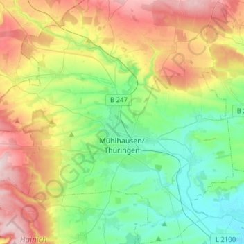
Name: Topografische Karte Mühlhausen/Thüringen, Höhe, Relief.
Durchschnittliche Höhe: 295 m
Minimale Höhe: 174 m
Maximale Höhe: 495 m
Andere topografische Karten
Klicken Sie auf eine Karte, um ihre Topografie, ihre Höhe und ihr Relief anzuzeigen.
Hollenbach
Deutschland > Thüringen > Unstrut-Hainich-Kreis > Mühlhausen/Thüringen
Durchschnittliche Höhe: 291 m
Reiser
Deutschland > Thüringen > Unstrut-Hainich-Kreis
Reiser liegt idyllisch im Tal der Unstrut. In näherer Umgebung befinden sich das Naturschutzgebiet Flachstal, ein langgezogenes Trockental, und das Landschaftsschutzgebiet „Reiserscher Hagen“, das um eine Flussschlinge der Unstrut festgelegt wurde. Der Ort selbst besteht vor allem aus mehreren…
Durchschnittliche Höhe: 274 m
Eigenrode
Deutschland > Thüringen > Unstrut-Hainich-Kreis
Die Wasserknappheit der grundwasserfernen Höhenlagen bewog die Einwohner, im 19. Jahrhundert Brunnen zu bauen. Deshalb gibt es heute noch das Brunnenfest. Erst ab 1928, nach dem Bau einer Wasserleitung, wurde die Wasserknappheit beseitigt.
Durchschnittliche Höhe: 377 m
Mühlhausen/Thüringen
Deutschland > Thüringen > Unstrut-Hainich-Kreis > Mühlhausen > Mühlhausen/Thüringen
Die nächste Wetterstation mit längerer Messreihe befindet sich etwa 3 km nordöstlich von Mühlhausen im Ortsteil Grabe. Sie liefert zumindest für die in Randlage des Thüringer Beckens gelegenen östlichen Stadtteile von Mühlhausen vergleichbare Werte. Mit 8,7 °C Jahresmitteltemperatur und 565 mm…
Durchschnittliche Höhe: 234 m
Horsmar
Deutschland > Thüringen > Unstrut-Hainich-Kreis
Horsmar liegt im oberen Unstruttal zwischen den Städten Dingelstädt im Nordwesten und Mühlhausen im Osten. Die Gemarkung reicht im Westen und Norden bis zum Mühlhäuser Landgraben, der das im Westen davon liegende katholische Eichsfeld vom östlich davon gelegenen evangelischen, ehemaligen Gebiet der…
Durchschnittliche Höhe: 316 m
Langula
Deutschland > Thüringen > Unstrut-Hainich-Kreis > Vogtei
Die Ortslage von Langula liegt am Westrand des Thüringer Beckens, ca. 7 km von Mühlhausen/Thüringen entfernt und ca. 20 km nordwestlich von Bad Langensalza in einer Höhenlage von etwa 240 m (Kirche). Die Gemarkung schließt im Westen jedoch große Waldgebiete des Hainich mit ein. Mit einer Gipfelhöhe von…
Durchschnittliche Höhe: 252 m
Großwelsbach
Deutschland > Thüringen > Unstrut-Hainich-Kreis > Bad Langensalza
Durchschnittliche Höhe: 211 m
Merxleben
Deutschland > Thüringen > Unstrut-Hainich-Kreis > Bad Langensalza
Durchschnittliche Höhe: 194 m
Steinacker
Deutschland > Thüringen > Unstrut-Hainich-Kreis > Südeichsfeld
Durchschnittliche Höhe: 416 m
Wiegleben
Deutschland > Thüringen > Unstrut-Hainich-Kreis > Bad Langensalza
Durchschnittliche Höhe: 323 m
Ammern
Deutschland > Thüringen > Unstrut-Hainich-Kreis
Der Ortsteil Ammern liegt nördlich von Mühlhausen/Thüringen am Stadtrand und in der Unstrutaue. Östlich des Dorfes verläuft durch die angrenzende Gemarkung die stark befahrene Bundesstraße 247. Sie führt in das Eichsfeld. Es gibt einen Haltepunkt an der Bahnstrecke Gotha–Leinefelde. Die Ackerböden in…
Durchschnittliche Höhe: 236 m
Beyrode
Deutschland > Thüringen > Unstrut-Hainich-Kreis > Unstruttal > Horsmar > Beyrode
Durchschnittliche Höhe: 305 m
Bickenriede
Deutschland > Thüringen > Unstrut-Hainich-Kreis > Anrode > Bickenriede
Durchschnittliche Höhe: 332 m
Thamsbrück
Deutschland > Thüringen > Unstrut-Hainich-Kreis > Bad Langensalza
Thamsbrück liegt im Westen des Thüringer Beckens etwa vier Kilometer nördlich von Bad Langensalza auf einer Höhe von 175 Metern über NHN. Die Umgebung ist landwirtschaftlich geprägt. Am Süd- und Westrand des Ortes fließt die Unstrut, mit zwei Flussläufen, in Richtung Osten zur Saale. Der von Norden…
Durchschnittliche Höhe: 189 m
Windeberg
Deutschland > Thüringen > Unstrut-Hainich-Kreis > Mühlhausen > Windeberg
Durchschnittliche Höhe: 357 m