
Topografische Karte Southampton
Klicken Sie auf die Karte, um die Höhe anzuzeigen.
Über diese Karte
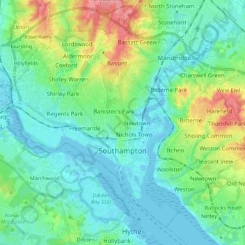
Name: Topografische Karte Southampton, Höhe, Relief.
Ort: Southampton, England, Vereinigtes Königreich (50.87151 -1.47901 50.95613 -1.32199)
Durchschnittliche Höhe: 22 m
Minimale Höhe: -4 m
Maximale Höhe: 92 m
Andere topografische Karten
Klicken Sie auf eine Karte, um ihre Topografie, ihre Höhe und ihr Relief anzuzeigen.
London
Vereinigtes Königreich > England > London
Südostengland mit der Hauptstadt London, der klimatisch meistbegünstigte Teil Großbritanniens, unterscheidet sich in vielerlei Hinsicht von den anderen Teilen der Insel. Die geologische Struktur wird durch die mesozoischen Sedimente bestimmt, die eine großzügig gegliederte Schichtstufenlandschaft…
Durchschnittliche Höhe: 42 m
Scafell Pike
Vereinigtes Königreich > England > Cumberland
Die Ursache dafür, dass der höhere Gipfel verwirrenderweise wie ein Nebengipfel bezeichnet ist, liegt darin, dass die heute als Scafell Pike, Ill Crag und Broad Crag bekannte Dreiergruppe von Gipfeln früher kollektiv als Pikes of Sca Fell bezeichnet wurde. Da der Sca Fell von Süden und Westen aus gesehen…
Durchschnittliche Höhe: 679 m
Great Yarmouth
Vereinigtes Königreich > England > Norfolk > Great Yarmouth
Durchschnittliche Höhe: 2 m
Standeford
Vereinigtes Königreich > England > Staffordshire > South Staffordshire > Coven
Durchschnittliche Höhe: 103 m
Knepp Castle
Vereinigtes Königreich > England > West Sussex > Horsham > Shipley
Durchschnittliche Höhe: 17 m
Ramsgate Western Undercliffe
Vereinigtes Königreich > England > Kent > Thanet District > Ramsgate > Pegwell
Durchschnittliche Höhe: 14 m
Wimpstone
Vereinigtes Königreich > England > Warwickshire > Stratford-on-Avon
Durchschnittliche Höhe: 60 m
Hemel Hempstead
Vereinigtes Königreich > England > Hertfordshire > Dacorum
Durchschnittliche Höhe: 130 m
Scarborough
Vereinigtes Königreich > England > North Yorkshire
Der Anstieg der Besucherzahlen Scarboroughs inspirierte einen jungen Architekten namens John Gibson, das erste zweckgebundene Hotelgebäude zu entwerfen, welches später als Crown Spa Hotel eröffnen sollte. Als 1841 der Bau einer Bahnlinie von York nach Scarborough ins Gespräch gebracht wurde, sah er die…
Durchschnittliche Höhe: 39 m
Brighton
Vereinigtes Königreich > England > Brighton and Hove
Am 4. August 2016 wurde an Brightons Seestrand, in direkter Nachbarschaft zum West Pier, der 173 Meter hohe Aussichtsturm British Airways i360 eröffnet. Es ist mit einer erreichbaren Plattformhöhe von 138 Metern die zweithöchste öffentlich begehbare Aussichtsplattform im Vereinigten Königreich und das…
Durchschnittliche Höhe: 28 m
Polruan
Vereinigtes Königreich > England > Cornwall
Polruan ist ein altes Fischerdorf mit langer Bootsbautradition, heute gibt es noch einen Bootsbaubetrieb im Dorf. Die Ruine der Kapelle St Saviour auf dem Gipfel der Anhöhe über dem Dorf stammt aus dem 13. Jahrhundert. Im 14. oder 15. Jahrhundert wurde das Polruan Blockhouse an der Spitze der Landzunge zum…
Durchschnittliche Höhe: 31 m
Matlock
Vereinigtes Königreich > England > Derbyshire > Derbyshire Dales
1893 wurde nach dem Vorbild der Cable cars in San Francisco eine Kabelstraßenbahn errichtet; die Trasse war zur Zeit des Baus die steilste der Welt und überwand ca. 100 Höhenmeter. Sie wurde 1927 geschlossen, nachdem Autos und Busse den Personentransport übernommen hatten.
Durchschnittliche Höhe: 213 m
Wimbledon
Vereinigtes Königreich > England
Ende der 1920er Jahre erreichte die Bevölkerungszahl ihren Höhepunkt und der Schwerpunkt des Wachstums verlagerte sich nach dem Bau der Northern Line in Richtung Morden, das bis dahin noch ländlich geblieben war. Die Southern Railway baute den Bahnhof Wimbledon um und eröffnete 1930 eine neue…
Durchschnittliche Höhe: 26 m
Sinope
Vereinigtes Königreich > England > Leicestershire > North West Leicestershire > Coalville
Durchschnittliche Höhe: 144 m
Rendlesham Forest
Vereinigtes Königreich > England > Suffolk > East Suffolk
Durchschnittliche Höhe: 19 m
King's Lynn
Vereinigtes Königreich > England > Norfolk > King's Lynn and West Norfolk
King’s Lynn ist eine ca. 45.000 Einwohner zählende Stadt (market town) in Großbritannien. Sie liegt in der Grafschaft Norfolk in der Nähe der Grenze zur Grafschaft Cambridgeshire am Fluss Great Ouse, knapp vor dessen Mündung in das sogenannte The Wash der Nordsee. In unmittelbarer Nähe beginnen die…
Durchschnittliche Höhe: 7 m
Barford St Michael
Vereinigtes Königreich > England > Oxfordshire > Cherwell District
Durchschnittliche Höhe: 119 m
Silbury Hill
Vereinigtes Königreich > England > Wiltshire > Beckhampton
Der Silbury Hill, gelegen bei dem Dörfchen Avebury in der zeremoniellen Grafschaft Wiltshire im Südwesten Großbritanniens, ist mit knapp 40 m Höhe, 167 m Durchmesser und einem Rauminhalt von ca. 248.000 m³ der größte prähistorische künstliche Hügel Europas und einer der größten der Welt. Den Gipfel…
Durchschnittliche Höhe: 166 m
Brandon Hill
Vereinigtes Königreich > England > City of Bristol > Bristol
Durchschnittliche Höhe: 39 m
New Herrington
Vereinigtes Königreich > England > Tyne and Wear > Sunderland
Durchschnittliche Höhe: 76 m
Acre Bridge
Vereinigtes Königreich > England > Lincolnshire > East Lindsey > Conisholme
Durchschnittliche Höhe: 2 m
Schloss Windsor
Vereinigtes Königreich > England > Windsor and Maidenhead > Windsor > Clewer Village
König Eduard III. wurde 1312 auf Schloss Windsor geboren. Er wurde deshalb häufig Eduard von Windsor genannt. Ab 1350 begann er ein 24 Jahre dauerndes Umbauprogramm, bei dem er das bestehende Schloss bis auf den Glockenturm (T) und einige kleinere Außenanlagen abreißen ließ. Er beauftragte William von…
Durchschnittliche Höhe: 23 m
Spittal
Vereinigtes Königreich > England > Northumberland > Berwick-upon-Tweed
Durchschnittliche Höhe: 26 m
Long Compton
Vereinigtes Königreich > England > Warwickshire > Stratford-on-Avon
Durchschnittliche Höhe: 147 m
Bluebell Hill
Vereinigtes Königreich > England > Kent > Tonbridge and Malling
Durchschnittliche Höhe: 129 m
Saffron Walden
Vereinigtes Königreich > England > Essex > Uttlesford
Die Stadt befindet sich am Fluss Cam 24 km (Fahrtstrecke) südlich von Cambridge bzw. ca. 80 km nördlich von London in einer Höhe von ca. 55 m. Das Klima wird in hohem Maße von der ca. 60 km (Luftlinie) entfernten Nordsee beeinflusst, Regen (ca. 700–800 mm/Jahr) fällt übers Jahr verteilt.
Durchschnittliche Höhe: 88 m
Eaglethorpe
Vereinigtes Königreich > England > North Northamptonshire > Warmington
Durchschnittliche Höhe: 31 m
Uffington
Vereinigtes Königreich > England > Lincolnshire > South Kesteven
Durchschnittliche Höhe: 30 m
River Lune
Vereinigtes Königreich > England > Lancashire > Lancaster > Caton > Halton Green
Durchschnittliche Höhe: 52 m
Littler
Vereinigtes Königreich > England > Cheshire West and Chester > Winsford
Durchschnittliche Höhe: 53 m
Bricket Wood
Vereinigtes Königreich > England > Hertfordshire > St Albans
Durchschnittliche Höhe: 82 m
Reigate
Vereinigtes Königreich > England > Surrey > Reigate and Banstead
Durchschnittliche Höhe: 100 m
Northmoor Corner
Vereinigtes Königreich > England > Somerset > North Petherton > North Newton
Durchschnittliche Höhe: 15 m
Hull
Vereinigtes Königreich > England > Kingston upon Hull
Kingston upon Hull ist 248 Kilometer nördlich von London am Nordufer der Mündung des Humbers in die Nordsee gelegen. Das Stadtzentrum befindet sich westlich des Hulls und nahe am Humber. Der Untergrund der Stadt besteht aus alluvialem Schwemmboden sowie glazialen Ablagerungen. Darunter befindet sich…
Durchschnittliche Höhe: 21 m
Avebury Stone Circle
Vereinigtes Königreich > England > Wiltshire > Beckhampton
Durchschnittliche Höhe: 165 m
Blackpool
Vereinigtes Königreich > England > Blackpool
Hinzu kam die Konkurrenz von Freizeitparks. Am Ende des 20. Jahrhunderts wurde die Stadt bei der britischen Bevölkerung häufig mit einem billigen, kitschigen Ort für wilde Junggesellenabschiede assoziiert. Trotzdem blieb Blackpool eine tourismuszentrierte Stadt, und die Stadtverwaltung investierte Millionen…
Durchschnittliche Höhe: 7 m
Acre Bridge
Vereinigtes Königreich > England > Lincolnshire > East Lindsey > Conisholme
Durchschnittliche Höhe: 2 m
Brook
Vereinigtes Königreich > England > Hampshire > New Forest > Bramshaw
Durchschnittliche Höhe: 65 m
Droitwich Spa
Vereinigtes Königreich > England > Worcestershire > Wychavon
Durchschnittliche Höhe: 49 m
Redhill
Vereinigtes Königreich > England > Surrey > Reigate and Banstead
Durchschnittliche Höhe: 107 m
Poole
Vereinigtes Königreich > England > Bournemouth, Christchurch and Poole
Durchschnittliche Höhe: 16 m