Topografische Karte Missoula
Interaktive Karte
Klicken Sie auf die Karte, um die Höhe anzuzeigen.
Über diese Karte
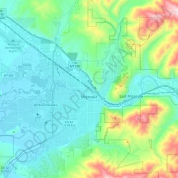
Name: Topografische Karte Missoula, Höhe, Relief.
Ort: Missoula, Missoula County, Montana, United States (46.79154 -114.12729 46.94995 -113.89732)
Durchschnittliche Höhe: 1’173 m
Minimale Höhe: 943 m
Maximale Höhe: 2’021 m
Missoula is located at the western edge of Montana, approximately 45 miles (70 km) from the Idaho border. The city is at an elevation of 3,209 feet (978 m) above sea level, with nearby Mount Sentinel and Mount Jumbo steeply rising to 5,158 feet (1,572 m) and 4,768 feet (1,453 m), respectively. According to the Census Bureau's 2015 figures, the city had a total area of 29.08 square miles (75.3 km2), of which 28.90 square miles (74.9 km2) were land and 0.184 square miles (0.48 km2) were covered by water.
Andere topografische Karten
Klicken Sie auf eine Karte, um ihre Topografie, ihre Höhe und ihr Relief anzuzeigen.
Frenchtown
United States > Montana > Missoula County > Frenchtown
Frenchtown, Missoula County, Montana, United States
Durchschnittliche Höhe: 1’019 m
Seeley Lake
United States > Montana > Missoula County
Seeley Lake, Missoula County, Montana, United States
Durchschnittliche Höhe: 1’348 m
Missoula
United States > Montana > Missoula County > Missoula
Missoula, Missoula County, Montana, 59807, United States
Durchschnittliche Höhe: 1’354 m
De Smet
United States > Montana > Missoula County
De Smet, Missoula County, Montana, 59808, United States
Durchschnittliche Höhe: 996 m
Condon
United States > Montana > Missoula County
Condon, Missoula County, Montana, 59826, United States
Durchschnittliche Höhe: 1’146 m
Seeley Lake
United States > Montana > Missoula County
Seeley Lake, Missoula County, Montana, 59868, United States
Durchschnittliche Höhe: 1’250 m
Clinton
United States > Montana > Missoula County
Clinton, Missoula County, Montana, United States
Durchschnittliche Höhe: 1’180 m
Lolo
United States > Montana > Missoula County > Lolo
Lolo, Missoula County, Montana, United States
Durchschnittliche Höhe: 1’077 m
Clearwater Lake
United States > Montana > Missoula County
Clearwater Lake, Missoula County, Montana, United States
Durchschnittliche Höhe: 1’491 m
Lolo Hot Springs
United States > Montana > Missoula County > Lolo Hot Springs
Lolo Hot Springs, Missoula County, Montana, United States
Durchschnittliche Höhe: 1’377 m
Huston
United States > Montana > Missoula County
Huston, Missoula County, Montana, United States
Durchschnittliche Höhe: 2’321 m