
Spenden
Rüste dich für dein nächstes Abenteuer:
Als Amazon-Partner verdient diese Seite an qualifizierten Käufen, ohne dass Ihnen zusätzliche Kosten entstehen.
Topografische Karte Cortez
Klicken Sie auf die Karte, um die Höhe anzuzeigen.
Spenden
Rüste dich für dein nächstes Abenteuer:
Als Amazon-Partner verdient diese Seite an qualifizierten Käufen, ohne dass Ihnen zusätzliche Kosten entstehen.
Cortez
Das mittlere Haushaltseinkommen in Cortez betrug 28.776 US-Dollar und das mittlere Familieneinkommen erreichte die Höhe von 35.533 US-Dollar. Das Durchschnittseinkommen der Männer betrug 30.755 US-Dollar, gegenüber 20.280 US-Dollar bei den Frauen. Das Pro-Kopf-Einkommen in Cortez war 18.040 US-Dollar. 18,6 % der Bevölkerung und 14,8 % der Familien hatten ein Einkommen unterhalb der Armutsgrenze, davon waren 27,3 % der Minderjährigen und 17,3 % der Altersgruppe 65 Jahre und mehr betroffen.
Spenden
Rüste dich für dein nächstes Abenteuer:
Als Amazon-Partner verdient diese Seite an qualifizierten Käufen, ohne dass Ihnen zusätzliche Kosten entstehen.
Über diese Karte
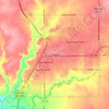
Name: Topografische Karte Cortez, Höhe, Relief.
Durchschnittliche Höhe: 1’865 m
Minimale Höhe: 1’784 m
Maximale Höhe: 1’901 m
Spenden
Rüste dich für dein nächstes Abenteuer:
Als Amazon-Partner verdient diese Seite an qualifizierten Käufen, ohne dass Ihnen zusätzliche Kosten entstehen.