
Topografische Karte Triest
Interaktive Karte
Klicken Sie auf die Karte, um die Höhe anzuzeigen.
Über diese Karte
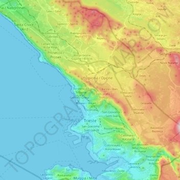
Name: Topografische Karte Triest, Höhe, Relief.
Durchschnittliche Höhe: 173 m
Minimale Höhe: -1 m
Maximale Höhe: 533 m
Andere topografische Karten
Klicken Sie auf eine Karte, um ihre Topografie, ihre Höhe und ihr Relief anzuzeigen.
Triest
Italien > Friaul-Julisch Venetien > Triest
Triest hat eine sehr lange Küstenlinie, freien Meerzugang in Barcola und ist von Grünland, Wald- und Karstflächen umgeben. In der Stadt befand sich auf dem Molo Sartorio der Mareograf, auf dessen festgelegte Werte aus den Jahren 1875 und 1900 sich in Mitteleuropa die meisten Bezugshöheangaben mit der…
Durchschnittliche Höhe: 216 m