Geolokalisieren

Topografische Karte Albenga

Interaktive Karte

Klicken Sie auf die Karte, um die Höhe anzuzeigen.

Über diese Karte

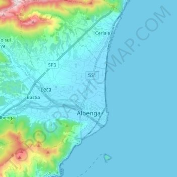
Name: Topografische Karte Albenga, Höhe, Relief.

Ort: Albenga, Savona, Liguria, Italy (44.02287 8.09942 44.10121 8.22985)

Durchschnittliche Höhe: 85 m

Minimale Höhe: -1 m

Maximale Höhe: 761 m

The current design is the result of further elevations. The restoration works between 1964 and 1967 brought back the cathedral design to its original medieval aspect. The nearby steeple was attached to the church in the 13th century, built over the ruins of the old bell tower between the years 1391 and 1395. This construction is one of the last local examples of the use of bare bricks, progressively replaced by plastering.