
Topografische Karte Aniakchak National Monument
Interaktive Karte
Klicken Sie auf die Karte, um die Höhe anzuzeigen.
Über diese Karte
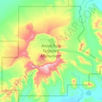
Name: Topografische Karte Aniakchak National Monument, Höhe, Relief.
Durchschnittliche Höhe: 376 m
Minimale Höhe: 31 m
Maximale Höhe: 1’321 m
Andere topografische Karten
Klicken Sie auf eine Karte, um ihre Topografie, ihre Höhe und ihr Relief anzuzeigen.
Denali
Vereinigte Staaten von Amerika > Alaska > Denali Borough
Der Denali oder Mount McKinley in Alaska ist mit 6190 Metern Höhe der höchste Berg Nordamerikas. Er ist damit einer der Seven Summits, der jeweils höchsten Berge der sieben Kontinente.
Durchschnittliche Höhe: 5’546 m
Jackson Hole
Vereinigte Staaten von Amerika > Alaska > Unorganized Borough
Durchschnittliche Höhe: 100 m
Fairbanks
Vereinigte Staaten von Amerika > Alaska > Fairbanks North Star
Durchschnittliche Höhe: 216 m
Wrangell Mountains
Vereinigte Staaten von Amerika > Alaska > Unorganized Borough
Durchschnittliche Höhe: 2’297 m
Prudhoe Bay
Vereinigte Staaten von Amerika > Alaska > North Slope
Nach Prudhoe Bay führt von Fairbanks der 666 Kilometer lange und bis auf die Höhe von 1415 m ansteigende Dalton Highway, der lange Zeit für den Privatverkehr gesperrt war.
Durchschnittliche Höhe: 10 m
Windy Ridge
Vereinigte Staaten von Amerika > Alaska > Unorganized Borough
Durchschnittliche Höhe: 101 m
Angoon
Vereinigte Staaten von Amerika > Alaska > Unorganized Borough > Angoon
1882 wurde bei einem Unfall auf einem Walfänger ein Mitglied des Tlingit-Stamms getötet. Die Northwest Trading Company wollte der Entschädigungsforderung durch die Angehörigen des Opfers nicht nachkommen und wandte sich an die United States Navy in Sitka um Hilfe. Angoon wurde daraufhin unter Beschuss…
Durchschnittliche Höhe: 38 m
Hoonah-Angoon (CA)
Vereinigte Staaten von Amerika > Alaska > Hoonah-Angoon (CA)
Durchschnittliche Höhe: 335 m
Alatna River
Vereinigte Staaten von Amerika > Alaska > Unorganized Borough
Durchschnittliche Höhe: 327 m
Point Barrow
Vereinigte Staaten von Amerika > Alaska
Point Barrow war auch ein Raketenstartgelände der NASA, das von 1965 bis 1972 zum Start von Höhenforschungsraketen der Typen Nike Cajun und Nike Apache verwendet wurde.
Durchschnittliche Höhe: 0 m