
Topografische Karte Karpenisi
Interaktive Karte
Klicken Sie auf die Karte, um die Höhe anzuzeigen.
Karpenisi
Auf dem Hügel Agios Dimitrios in der Nähe der Kleinstadt Karpenisi sind antike Überreste gefunden worden, welche auf eine Besiedlung der Gegend bereits in antiker Zeit hindeuten. Eine antike Siedlung in der Region des heutigen Karpenisi konnte mit Sicherheit bis heute nicht nachgewiesen werden. Der Name Karpenisi wurde erstmals im 12. Jahrhundert durch die Kutsovlachen bzw. Walachen erwähnt. Das genaue Gründungsdatum der heutigen Siedlung ist unbekannt. Unter osmanischer Herrschaft war Karpenisi bereits das Verwaltungs- und Handelszentrum der umliegenden, teils von Walachen, teils von Griechen bewohnten Dörfern der Region Evrytania. Zwischen 1645 und 1814 existierte in Karpenisi eine höhere griechische Schule. Anfang des 16. Jahrhunderts wurde Karpenisi zum Bischofssitz des Bistums Litsa und Agrafa erhoben. 1821 erfolgte in Karpenisi ein erfolgreicher Angriff griechischer Rebellen im Rahmen des griechischen Unabhängigkeitskrieges auf die dort stationierte osmanische Garnison, welcher mit einem griechischen Sieg und der Eroberung von Karpenisi endete. Nach der Befreiung Karpenisis wurde die Stadt unter Rückgriff auf die antike Hauptstadt von Evrytania Ichialia genannt; bereits 1840 kehrte man zum Namen Karpenisi zurück.
Über diese Karte
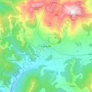
Name: Topografische Karte Karpenisi, Höhe, Relief.
Durchschnittliche Höhe: 1’236 m
Minimale Höhe: 710 m
Maximale Höhe: 2’301 m