Topografische Karte Vermont
Interaktive Karte
Klicken Sie auf die Karte, um die Höhe anzuzeigen.
Über diese Karte
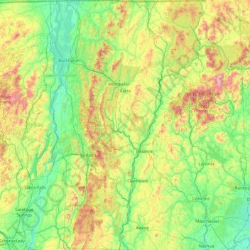
Name: Topografische Karte Vermont, Höhe, Relief.
Ort: Vermont, United States (42.72696 -73.43774 45.01667 -71.46539)
Durchschnittliche Höhe: 348 m
Minimale Höhe: -2 m
Maximale Höhe: 1’893 m
The topography and climate make sections of Vermont subject to large-scale flooding. Incidents include the Great Vermont Flood of 1927, which killed 84 and damaged much of the state's infrastructure, the flood of 1973, which covered many of the state's roads in the southeast, and Tropical Storm Irene in 2011, which caused substantial damage throughout the state. In response to the 1927 flood, the Federal government funded construction of six flood control dams in the state, run by the Army Corps of Engineers. These extreme rain and flooding events are expected to get worse with climate change.
Andere topografische Karten
Klicken Sie auf eine Karte, um ihre Topografie, ihre Höhe und ihr Relief anzuzeigen.
Montgomery County
Montgomery County, Texas, United States
Durchschnittliche Höhe: 69 m
Houston
United States > Texas > Harris County
Houston, Harris County, Texas, United States
Durchschnittliche Höhe: 25 m
The Woodlands
United States > Texas > Montgomery County
The Woodlands, Montgomery County, Texas, United States
Durchschnittliche Höhe: 47 m
Los Angeles
Los Angeles, Los Angeles County, California, United States
Durchschnittliche Höhe: 241 m
New Orleans
United States > Louisiana > Orleans Parish
New Orleans, Orleans Parish, Louisiana, United States
Durchschnittliche Höhe: 1 m
Brooklyn
United States > New York > New York
Brooklyn, Kings County, New York, United States
Durchschnittliche Höhe: 9 m
Boulder
United States > Colorado > Boulder County
Boulder, Boulder County, Colorado, United States
Durchschnittliche Höhe: 1’785 m
Albuquerque
United States > New Mexico > Bernalillo County
Albuquerque, Bernalillo County, New Mexico, United States
Durchschnittliche Höhe: 1’688 m
Jacksonville
United States > Florida > Duval County
Jacksonville, Duval County, Florida, United States
Durchschnittliche Höhe: 10 m
Middle East
United States > Maryland > Baltimore
Middle East, Baltimore, Maryland, United States
Durchschnittliche Höhe: 29 m
Miami-Dade County
Miami-Dade County, Florida, United States
Durchschnittliche Höhe: 3 m
Great Smoky Mountains National Park
United States > Tennessee > Sevier County
Great Smoky Mountains National Park, Sevier County, East Tennessee, Tennessee, United States
Durchschnittliche Höhe: 765 m
Hudson River
Hudson River, New Jersey, 12834:12871, United States
Durchschnittliche Höhe: 297 m
College Station
United States > Texas > Brazos County
College Station, Brazos County, Texas, United States
Durchschnittliche Höhe: 87 m
Spokane
United States > Washington > Spokane County
Spokane, Spokane County, Washington, United States
Durchschnittliche Höhe: 655 m
Santa Fe
United States > New Mexico > Santa Fe County
Santa Fe, Santa Fe County, New Mexico, United States
Durchschnittliche Höhe: 2’221 m
Fairfax County
Fairfax County, Virginia, United States
Durchschnittliche Höhe: 75 m
Appalachian Mountains
United States > North Carolina > Yancey County
Appalachian Mountains, Yancey County, North Carolina, United States
Durchschnittliche Höhe: 1’463 m
Charlottesville
Charlottesville, Virginia, United States
Durchschnittliche Höhe: 138 m