
Spenden
Rüste dich für dein nächstes Abenteuer:
Als Amazon-Partner verdient diese Seite an qualifizierten Käufen, ohne dass Ihnen zusätzliche Kosten entstehen.
Topografische Karte Denali
Klicken Sie auf die Karte, um die Höhe anzuzeigen.
Spenden
Rüste dich für dein nächstes Abenteuer:
Als Amazon-Partner verdient diese Seite an qualifizierten Käufen, ohne dass Ihnen zusätzliche Kosten entstehen.
Denali
Der Denali (von 1917 bis 2015 offiziell Mount McKinley) in Alaska ist mit 6190 Metern Höhe der höchste Berg Nordamerikas. Er gehört damit zu den Seven Summits, den jeweils höchsten Bergen der sieben Kontinente.
Spenden
Rüste dich für dein nächstes Abenteuer:
Als Amazon-Partner verdient diese Seite an qualifizierten Käufen, ohne dass Ihnen zusätzliche Kosten entstehen.
Über diese Karte
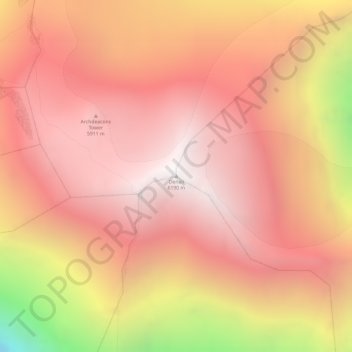
Name: Topografische Karte Denali, Höhe, Relief.
Durchschnittliche Höhe: 5’546 m
Minimale Höhe: 4’151 m
Maximale Höhe: 6’170 m
Spenden
Rüste dich für dein nächstes Abenteuer:
Als Amazon-Partner verdient diese Seite an qualifizierten Käufen, ohne dass Ihnen zusätzliche Kosten entstehen.