
Spenden
Rüste dich für dein nächstes Abenteuer:
Als Amazon-Partner verdient diese Seite an qualifizierten Käufen, ohne dass Ihnen zusätzliche Kosten entstehen.
Topografische Karte Süd-Carolina
Klicken Sie auf die Karte, um die Höhe anzuzeigen.
Spenden
Rüste dich für dein nächstes Abenteuer:
Als Amazon-Partner verdient diese Seite an qualifizierten Käufen, ohne dass Ihnen zusätzliche Kosten entstehen.
Über diese Karte
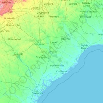
Name: Topografische Karte Süd-Carolina, Höhe, Relief.
Ort: Süd-Carolina, Vereinigte Staaten von Amerika (32.03345 -83.35400 35.21549 -78.54135)
Durchschnittliche Höhe: 85 m
Minimale Höhe: -4 m
Maximale Höhe: 1’642 m
Spenden
Rüste dich für dein nächstes Abenteuer:
Als Amazon-Partner verdient diese Seite an qualifizierten Käufen, ohne dass Ihnen zusätzliche Kosten entstehen.
Andere topografische Karten
Klicken Sie auf eine Karte, um ihre Topografie, ihre Höhe und ihr Relief anzuzeigen.
Palm Harbor
Vereinigte Staaten von Amerika > Florida > Pinellas County > Dunedin
Durchschnittliche Höhe: 7 m
Weymouth Landing
Vereinigte Staaten von Amerika > Massachusetts > Norfolk County > Weymouth
Durchschnittliche Höhe: 21 m
Spenden
Rüste dich für dein nächstes Abenteuer:
Als Amazon-Partner verdient diese Seite an qualifizierten Käufen, ohne dass Ihnen zusätzliche Kosten entstehen.
Dieffenbach
Vereinigte Staaten von Amerika > Pennsylvania > Montour County > Derry Township
Durchschnittliche Höhe: 172 m
Portland
Vereinigte Staaten von Amerika > Oregon > Multnomah County
Der Washington Park hat eine Fläche von 52,41 Hektar und befindet sich auf einer Anhöhe (61 bis 265 m). Er umfasst unter anderem den Oregon Zoo mit 200 Arten, einen Japanischen Garten mit einer Größe von 22.000 m², das 1928 gegründete Hoyt Arboretum mit 10.000 Bäumen, ein Kindermuseum sowie den…
Durchschnittliche Höhe: 80 m
Rocky Mountain
Vereinigte Staaten von Amerika > New York > Ulster County > Town of Shandaken
Durchschnittliche Höhe: 924 m
Spenden
Rüste dich für dein nächstes Abenteuer:
Als Amazon-Partner verdient diese Seite an qualifizierten Käufen, ohne dass Ihnen zusätzliche Kosten entstehen.
Weaverville
Vereinigte Staaten von Amerika > Kalifornien > Trinity County
Durchschnittliche Höhe: 972 m
Lincoln Heights
Vereinigte Staaten von Amerika > Nord-Carolina > Wilson County > Wilson
Durchschnittliche Höhe: 35 m
South Warren
Vereinigte Staaten von Amerika > Pennsylvania > Warren County
Durchschnittliche Höhe: 432 m
Spenden
Rüste dich für dein nächstes Abenteuer:
Als Amazon-Partner verdient diese Seite an qualifizierten Käufen, ohne dass Ihnen zusätzliche Kosten entstehen.
Maderia Hammock
Vereinigte Staaten von Amerika > Florida > Miami-Dade County
Durchschnittliche Höhe: 1 m
Flagstaff
Vereinigte Staaten von Amerika > Arizona > Coconino County
Flagstaff liegt auf rund 2100 m Höhe am Südwestrand des Colorado-Plateaus in einer durch Vulkanismus geprägten Landschaft. Nördlich der Stadt erheben sich die San Francisco Peaks mit dem Humphreys Peak, der mit 3852 m den höchsten Punkt in Arizona markiert.
Durchschnittliche Höhe: 2’176 m
Spenden
Rüste dich für dein nächstes Abenteuer:
Als Amazon-Partner verdient diese Seite an qualifizierten Käufen, ohne dass Ihnen zusätzliche Kosten entstehen.
Saint Luke
Vereinigte Staaten von Amerika > Virginia > Shenandoah County
Durchschnittliche Höhe: 334 m
Spenden
Rüste dich für dein nächstes Abenteuer:
Als Amazon-Partner verdient diese Seite an qualifizierten Käufen, ohne dass Ihnen zusätzliche Kosten entstehen.
National Park of American Samoa
Vereinigte Staaten von Amerika > Amerikanisch-Samoa > Eastern District > Pago Pago
Durchschnittliche Höhe: 146 m
Spenden
Rüste dich für dein nächstes Abenteuer:
Als Amazon-Partner verdient diese Seite an qualifizierten Käufen, ohne dass Ihnen zusätzliche Kosten entstehen.
Valdez
Vereinigte Staaten von Amerika > Alaska > Unorganized Borough > Valdez
Durchschnittliche Höhe: 843 m
North Fork Kuskokwim River
Vereinigte Staaten von Amerika > Alaska > Unorganized Borough
Durchschnittliche Höhe: 150 m
Spenden
Rüste dich für dein nächstes Abenteuer:
Als Amazon-Partner verdient diese Seite an qualifizierten Käufen, ohne dass Ihnen zusätzliche Kosten entstehen.
Wrangell Mountains
Vereinigte Staaten von Amerika > Alaska > Unorganized Borough
Durchschnittliche Höhe: 2’297 m
Furnace Creek
Vereinigte Staaten von Amerika > Kalifornien > Inyo County > Furnace Creek
Durchschnittliche Höhe: -27 m
Fairbanks
Vereinigte Staaten von Amerika > Alaska > Fairbanks North Star
Durchschnittliche Höhe: 146 m
Spenden
Rüste dich für dein nächstes Abenteuer:
Als Amazon-Partner verdient diese Seite an qualifizierten Käufen, ohne dass Ihnen zusätzliche Kosten entstehen.