
Spenden
Rüste dich für dein nächstes Abenteuer:
Als Amazon-Partner verdient diese Seite an qualifizierten Käufen, ohne dass Ihnen zusätzliche Kosten entstehen.
Topografische Karte Louisiana
Klicken Sie auf die Karte, um die Höhe anzuzeigen.
Spenden
Rüste dich für dein nächstes Abenteuer:
Als Amazon-Partner verdient diese Seite an qualifizierten Käufen, ohne dass Ihnen zusätzliche Kosten entstehen.
Louisiana
Louisiana [luˌ.iː.ziˈæ.nə] oder [luː.ziˈænə] (zu französisch Louisiane) ist ein Bundesstaat in den Regionen Deep South und South Central der Vereinigten Staaten von Amerika. Er grenzt im Westen an Texas, im Norden an Arkansas, im Osten an Mississippi und im Süden an den Golf von Mexiko. Von den 50 US-Bundesstaaten nimmt er mit rund 4,6 Millionen Einwohnern den 25. Platz und in Bezug auf die Fläche Platz 31 ein. In Anlehnung an sein französisches Erbe ist Louisiana der einzige US-Bundesstaat mit politischen Unterteilungen, die als Parishes bezeichnet werden und den Counties entsprechen. Damit ist er einer von nur zwei US-Bundesstaaten, die nicht in Counties unterteilt sind (der andere ist Alaska mit seinen Boroughs). Baton Rouge ist die Hauptstadt des Bundesstaates, und New Orleans ist mit rund 363.000 Einwohnern die bevölkerungsreichste Stadt des Bundesstaates. Beide Städte liegen am Mississippi River, durch den der Staat landschaftlich stark geprägt wird, insbesondere durch sein riesiges Mündungsdelta mit großen Sumpflandschaften, die eine reiche Flora und Fauna beherbergen, darunter Vögel wie Ibisse und Reiher, viele Arten von Laubfröschen – wie den staatlich anerkannten Amerikanischen Laubfrosch – und Fische wie Störe und Löffelstöre. In den höher gelegenen Gebieten, vor allem im Norden, gibt es eine Vielzahl von Ökosystemen wie die Tallgrass-Prärie, die Longleaf-Pine-Wälder und die Feuchtsavannen, die eine außergewöhnlich große Anzahl von Pflanzenarten beherbergen, darunter viele Arten von Landorchideen und fleischfressenden Pflanzen. Über die Hälfte des Staates ist bewaldet.
Spenden
Rüste dich für dein nächstes Abenteuer:
Als Amazon-Partner verdient diese Seite an qualifizierten Käufen, ohne dass Ihnen zusätzliche Kosten entstehen.
Über diese Karte
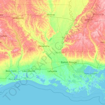
Name: Topografische Karte Louisiana, Höhe, Relief.
Ort: Louisiana, Vereinigte Staaten von Amerika (28.85429 -94.04319 33.01959 -88.75833)
Durchschnittliche Höhe: 39 m
Minimale Höhe: -4 m
Maximale Höhe: 196 m
Spenden
Rüste dich für dein nächstes Abenteuer:
Als Amazon-Partner verdient diese Seite an qualifizierten Käufen, ohne dass Ihnen zusätzliche Kosten entstehen.
Andere topografische Karten
Klicken Sie auf eine Karte, um ihre Topografie, ihre Höhe und ihr Relief anzuzeigen.
Rocky Mountains
Vereinigte Staaten von Amerika > Wyoming > Teton County
Die Vegetation der Rocky Mountains lässt sich in mehrere Höhenstufen unterteilen. Außer in den borealen Bereichen Kanadas, wo die von Fichten dominierten nordischen Nadelwälder der Ebenen in Bergwälder aus Fichten und Kiefern übergehen, sind die großflächigen unteren montanen Bereiche der Rockies im…
Durchschnittliche Höhe: 2’292 m
Grand Canyon
Vereinigte Staaten von Amerika > Arizona > Coconino County
Das Gebiet um das Tal wird in drei Regionen aufgeteilt: den Südrand (South Rim), der die meisten Besucher anzieht, den im Durchschnitt ca. 300 m höher gelegenen und kühleren Nordrand (North Rim) und die Innere Schlucht (Inner Canyon). Der Südrand des Grand Canyons liegt im Durchschnitt auf 2100 m ü. M.,…
Durchschnittliche Höhe: 1’023 m
Appalachen
Vereinigte Staaten von Amerika > Nord-Carolina > Yancey County
Die Appalachen (englisch Appalachian Mountains, französisch Appalaches) sind ein bewaldetes Gebirgssystem im Osten Nordamerikas, das sich (geologisch betrachtet) über eine Länge von 2400 Kilometern von den Long Range Mountains an der Westküste der kanadischen Insel Neufundland bis in den Norden des…
Durchschnittliche Höhe: 1’463 m
Spenden
Rüste dich für dein nächstes Abenteuer:
Als Amazon-Partner verdient diese Seite an qualifizierten Käufen, ohne dass Ihnen zusätzliche Kosten entstehen.
Fairplay
Vereinigte Staaten von Amerika > Colorado > Park County
Fairplay wurde zu Beginn des Colorado-Goldrauschs im Jahre 1859 gegründet, als Prospektoren am South Platte River auf Gold stießen. Die Gemeinde stellt den County Seat für das Park County und ist auf einer Höhe von 3034 m der fünfthöchstgelegene Ort in Colorado. Es handelt sich außerdem um die größte…
Durchschnittliche Höhe: 3’045 m
Marian Island
Vereinigte Staaten von Amerika > Minnesota > Lake of the Woods County
Durchschnittliche Höhe: 329 m
Albuquerque
Vereinigte Staaten von Amerika > Neumexiko > Bernalillo County
Albuquerque befindet sich in einer Ebene, die im Osten durch die Sandia Mountains und im Westen durch den von Nord nach Süd fließenden Rio Grande begrenzt wird. Das Stadtgebiet umfasst 469,6 km2 und erstreckt sich über Höhenlagen zwischen 1.490 m und 1.631 m.
Durchschnittliche Höhe: 1’671 m
Wrangell Mountains
Vereinigte Staaten von Amerika > Alaska > Unorganized Borough
Durchschnittliche Höhe: 2’297 m
Spenden
Rüste dich für dein nächstes Abenteuer:
Als Amazon-Partner verdient diese Seite an qualifizierten Käufen, ohne dass Ihnen zusätzliche Kosten entstehen.
Great Plains
Vereinigte Staaten von Amerika > Kansas > Thomas County
Die Ostgrenze wird unterschiedlich definiert. Manche Geografen verbinden sämtliche Ränder der Ebene, die auf 600 m Höhe liegen, und definieren die so entstandene Linie als Ostgrenze, wie in der grün schraffierten obigen Grafik. Andere ziehen die Grenze, entsprechend der Verbreitung der Hochgrasprärie,…
Durchschnittliche Höhe: 1’023 m
The Flatirons
Vereinigte Staaten von Amerika > Colorado > Boulder County
Durchschnittliche Höhe: 2’051 m
El Capitan
Vereinigte Staaten von Amerika > Kalifornien > Mariposa County
El Capitan ist kein Berg im eigentlichen Sinn, sondern ein riesiger, durch vulkanische Schmelzprozesse entstandener Granitblock. Er fällt nach Westen, Südwesten und Südosten faktisch senkrecht und nach Osten relativ sanft zum Merced River im Yosemite-Tal bzw. in die Schluchten seiner Zuflüsse ab. Im Westen…
Durchschnittliche Höhe: 1’814 m
Spenden
Rüste dich für dein nächstes Abenteuer:
Als Amazon-Partner verdient diese Seite an qualifizierten Käufen, ohne dass Ihnen zusätzliche Kosten entstehen.
Mauna Kea
Vereinigte Staaten von Amerika > Hawaii > Hawaii
Der Vulkan Mauna Kea (hawaiisch für Weißer Berg oder Mauna a Wākea) ist mit etwa 4205 m der höchste Berg auf Hawaii. Bezieht man bei der Messung der Höhe den unterhalb der Meeresoberfläche liegenden Anteil mit ein, gilt der Mauna Kea mit 10.203 Metern als höchster Berg der Erde. Mauna Kea wird in der…
Durchschnittliche Höhe: 3’978 m
Silicon Valley
Vereinigte Staaten von Amerika > Kalifornien > Santa Clara County > Palo Alto
Durchschnittliche Höhe: 118 m
Rocky Mountain National Park
Vereinigte Staaten von Amerika > Colorado
Durchschnittliche Höhe: 3’448 m
Spenden
Rüste dich für dein nächstes Abenteuer:
Als Amazon-Partner verdient diese Seite an qualifizierten Käufen, ohne dass Ihnen zusätzliche Kosten entstehen.
Monument Valley Navajo Tribal Park
Vereinigte Staaten von Amerika > Arizona > Navajo County
Das Monument Valley liegt in der Four-Corners-Region, an der Grenze zwischen Arizona und Utah, westlich der Staatsgrenzen zu Colorado und New Mexico in einer Höhe von fast 1900 m und wird bevölkerungsstatistisch in die beiden Schwestergebiete Oljato, Arizona und Oljato, Utah geteilt. Die Temperaturen im…
Durchschnittliche Höhe: 1’675 m
Denali
Vereinigte Staaten von Amerika > Alaska > Denali Borough
Der Denali oder Mount McKinley in Alaska ist mit 6190 Metern Höhe der höchste Berg Nordamerikas. Er ist damit einer der Seven Summits, der jeweils höchsten Berge der sieben Kontinente.
Durchschnittliche Höhe: 5’546 m
Antelope Canyon
Vereinigte Staaten von Amerika > Arizona > Coconino County
Durchschnittliche Höhe: 1’205 m
Pikes Peak
Vereinigte Staaten von Amerika > Colorado > El Paso County
Pikes Peak (früher Pike’s Peak) ist ein Berg mit einer Höhe von 4301 m (14.110 Fuß) in der Front Range der Rocky Mountains, nahe Colorado Springs, Colorado. Er wurde benannt nach Zebulon Pike, einem Forschungsreisenden, der 1806 die Pike-Expedition in das südliche Colorado anführte. Es handelt sich um…
Durchschnittliche Höhe: 3’902 m
Spenden
Rüste dich für dein nächstes Abenteuer:
Als Amazon-Partner verdient diese Seite an qualifizierten Käufen, ohne dass Ihnen zusätzliche Kosten entstehen.
Mauna Loa
Vereinigte Staaten von Amerika > Hawaii > Hawaii
Der Mauna Loa ist einer der größten aktiven Vulkane der Erde und liegt mitten im Pazifik auf Hawaii, der größten Insel der Inselgruppe von Hawaii. Der jüngste Ausbruch war Ende 2022. Auf über drei Kilometern Höhe liegt hier die NOAA-Messstation für den Kohlendioxidgehalt der Atmosphäre, deren…
Durchschnittliche Höhe: 4’037 m
Central Park
Vereinigte Staaten von Amerika > New York > New York County > New York
In den ersten fünf Jahren hatten die Arbeiter fast 2,5 Millionen yd3 (1,9 Millionen Kubikmeter) Steine und Erde bewegt – genug, um ein Fußballfeld um acht Stockwerke zu erhöhen. Mit Spitzhacken, Hämmern und Schaufeln und 166 t Schießpulver sprengten sie 300.000 yd3 Felsgestein aus Gneis, durchzogen von…
Durchschnittliche Höhe: 26 m
New York
Vereinigte Staaten von Amerika > New York
Manhattan steht auf Felsgrund, der es ermöglicht, auch höhere Bauwerke zu errichten. Es ist von zahlreichen Naturhäfen umgeben, die durch Schiffe mit großem Tiefgang angelaufen werden können. Der Hudson öffnet den wichtigsten natürlichen Weg ins Hinterland und ermöglicht es, über den Mohawk River bzw.…
Durchschnittliche Höhe: 15 m
Spenden
Rüste dich für dein nächstes Abenteuer:
Als Amazon-Partner verdient diese Seite an qualifizierten Käufen, ohne dass Ihnen zusätzliche Kosten entstehen.
Cajon Pass
Vereinigte Staaten von Amerika > Kalifornien > San Bernardino County
Der Cajon-Pass (Höhe 1151 m) ist ein Gebirgspass im US-Bundesstaat Kalifornien. Er bildet die Grenze zwischen den San Bernardino Mountains im Osten und den San Gabriel Mountains im Westen. Die Interstate 15 über den nahe gelegenen Cajon-Summit und die SR 138 über den Cajon-Pass direkt stellen die beiden…
Durchschnittliche Höhe: 1’169 m
Spenden
Rüste dich für dein nächstes Abenteuer:
Als Amazon-Partner verdient diese Seite an qualifizierten Käufen, ohne dass Ihnen zusätzliche Kosten entstehen.
Monument Valley Navajo Tribal Park
Vereinigte Staaten von Amerika > Arizona > Navajo County
Das Monument Valley liegt in der Four-Corners-Region, an der Grenze zwischen Arizona und Utah, westlich der Staatsgrenzen zu Colorado und New Mexico in einer Höhe von fast 1900 m und wird bevölkerungsstatistisch in die beiden Schwestergebiete Oljato, Arizona und Oljato, Utah geteilt. Die Temperaturen im…
Durchschnittliche Höhe: 1’675 m
Mount Shasta
Vereinigte Staaten von Amerika > Kalifornien > Siskiyou County
Der Mount Shasta (in der Karok-Sprache: „Úytaahkoo“, dt. „Weißer Berg“) ist ein Stratovulkan im Norden des US-Bundesstaats Kalifornien. Der gleichnamige Ort Mount Shasta mit etwa 3000 Einwohnern liegt am Fuß des Berges auf 1100 Metern Seehöhe.
Durchschnittliche Höhe: 3’717 m
Spenden
Rüste dich für dein nächstes Abenteuer:
Als Amazon-Partner verdient diese Seite an qualifizierten Käufen, ohne dass Ihnen zusätzliche Kosten entstehen.
Pierce Stocking Scenic Drive
Vereinigte Staaten von Amerika > Michigan > Leelanau County > Empire Township
Durchschnittliche Höhe: 227 m
Jersey Island
Vereinigte Staaten von Amerika > Kalifornien > Contra Costa County
Durchschnittliche Höhe: 59 m
Spenden
Rüste dich für dein nächstes Abenteuer:
Als Amazon-Partner verdient diese Seite an qualifizierten Käufen, ohne dass Ihnen zusätzliche Kosten entstehen.
Burtis Bay
Vereinigte Staaten von Amerika > New York > Chautauqua County > Town of Busti
Durchschnittliche Höhe: 409 m
Patchen (historic)
Vereinigte Staaten von Amerika > Kalifornien > Santa Clara County
Durchschnittliche Höhe: 459 m
Greenwood
Vereinigte Staaten von Amerika > Kentucky > Jefferson County > Louisville
Durchschnittliche Höhe: 153 m
Spenden
Rüste dich für dein nächstes Abenteuer:
Als Amazon-Partner verdient diese Seite an qualifizierten Käufen, ohne dass Ihnen zusätzliche Kosten entstehen.
Isaar
Vereinigte Staaten von Amerika > Wisconsin > Outagamie County > Town of Seymour
Durchschnittliche Höhe: 253 m
Lakeview
Vereinigte Staaten von Amerika > Louisiana > Orleans Parish > New Orleans
Durchschnittliche Höhe: 2 m
Spenden
Rüste dich für dein nächstes Abenteuer:
Als Amazon-Partner verdient diese Seite an qualifizierten Käufen, ohne dass Ihnen zusätzliche Kosten entstehen.
Elizabeth Street Garden
Vereinigte Staaten von Amerika > New York > New York County > New York
Durchschnittliche Höhe: 15 m
Gertrude
Vereinigte Staaten von Amerika > Arkansas > Miller County > Texarkana
Durchschnittliche Höhe: 120 m
Black Creek Village
Vereinigte Staaten von Amerika > New York > Niagara County > City of Niagara Falls
Durchschnittliche Höhe: 176 m
Spenden
Rüste dich für dein nächstes Abenteuer:
Als Amazon-Partner verdient diese Seite an qualifizierten Käufen, ohne dass Ihnen zusätzliche Kosten entstehen.
Rummel
Vereinigte Staaten von Amerika > Pennsylvania > Somerset County > Paint Township
Durchschnittliche Höhe: 600 m
Osprey
Vereinigte Staaten von Amerika > Florida > Sarasota County > Osprey
Durchschnittliche Höhe: 3 m
Spenden
Rüste dich für dein nächstes Abenteuer:
Als Amazon-Partner verdient diese Seite an qualifizierten Käufen, ohne dass Ihnen zusätzliche Kosten entstehen.
Dieffenbach
Vereinigte Staaten von Amerika > Pennsylvania > Montour County > Derry Township
Durchschnittliche Höhe: 172 m
Bay Port Colony
Vereinigte Staaten von Amerika > Florida > Hillsborough County
Durchschnittliche Höhe: 4 m
Knollwood
Vereinigte Staaten von Amerika > Süd-Carolina > Greenville County > Greenville
Durchschnittliche Höhe: 283 m
Spenden
Rüste dich für dein nächstes Abenteuer:
Als Amazon-Partner verdient diese Seite an qualifizierten Käufen, ohne dass Ihnen zusätzliche Kosten entstehen.
Newmans Pond
Vereinigte Staaten von Amerika > Georgia > Troup County > LaGrange
Durchschnittliche Höhe: 220 m
Four Mile
Vereinigte Staaten von Amerika > Mississippi > Humphreys County
Durchschnittliche Höhe: 33 m
Spenden
Rüste dich für dein nächstes Abenteuer:
Als Amazon-Partner verdient diese Seite an qualifizierten Käufen, ohne dass Ihnen zusätzliche Kosten entstehen.
Orchard Garden
Vereinigte Staaten von Amerika > Minnesota > Dakota County > Burnsville
Durchschnittliche Höhe: 303 m
Wiscon
Vereinigte Staaten von Amerika > Florida > Hernando County > Brooksville
Durchschnittliche Höhe: 30 m
Glenwood Hills
Vereinigte Staaten von Amerika > Neumexiko > Bernalillo County > Albuquerque
Durchschnittliche Höhe: 1’937 m
Red Rock / Tsé Łichííʼ Dah Azkání
Vereinigte Staaten von Amerika > Arizona > Apache County
Durchschnittliche Höhe: 1’780 m
Spenden
Rüste dich für dein nächstes Abenteuer:
Als Amazon-Partner verdient diese Seite an qualifizierten Käufen, ohne dass Ihnen zusätzliche Kosten entstehen.
Grant Grove Village
Vereinigte Staaten von Amerika > Kalifornien > Tulare County
Durchschnittliche Höhe: 2’015 m
Spenden
Rüste dich für dein nächstes Abenteuer:
Als Amazon-Partner verdient diese Seite an qualifizierten Käufen, ohne dass Ihnen zusätzliche Kosten entstehen.
Arbor
Vereinigte Staaten von Amerika > Kalifornien > Contra Costa County > Brentwood
Durchschnittliche Höhe: 29 m
Spenden
Rüste dich für dein nächstes Abenteuer:
Als Amazon-Partner verdient diese Seite an qualifizierten Käufen, ohne dass Ihnen zusätzliche Kosten entstehen.
Sierra Nevada
Vereinigte Staaten von Amerika > Kalifornien > Tulare County
Durchschnittliche Höhe: 3’888 m
Saint Ann
Vereinigte Staaten von Amerika > Missouri > Saint Louis County > St. Ann
Durchschnittliche Höhe: 183 m
Mammoth Lake
Vereinigte Staaten von Amerika > Texas > Brazoria County > Clute
Durchschnittliche Höhe: 7 m
Spenden
Rüste dich für dein nächstes Abenteuer:
Als Amazon-Partner verdient diese Seite an qualifizierten Käufen, ohne dass Ihnen zusätzliche Kosten entstehen.
Island Retreat
Vereinigte Staaten von Amerika > Georgia > Glynn County > St. Simons
Durchschnittliche Höhe: 5 m
Twistal Swamp
Vereinigte Staaten von Amerika > Minnesota > Kittson County
Durchschnittliche Höhe: 320 m
Double Dips Crossing
Vereinigte Staaten von Amerika > Oklahoma > Comanche County
Durchschnittliche Höhe: 408 m
Divide Creek
Vereinigte Staaten von Amerika > Montana > Glacier County
Durchschnittliche Höhe: 2’208 m
Spenden
Rüste dich für dein nächstes Abenteuer:
Als Amazon-Partner verdient diese Seite an qualifizierten Käufen, ohne dass Ihnen zusätzliche Kosten entstehen.
Alva, Oklahoma 73717
Vereinigte Staaten von Amerika > Oklahoma > Woods County > Alva
Durchschnittliche Höhe: 417 m
Anna Maria island
Vereinigte Staaten von Amerika > Florida > Manatee County
Durchschnittliche Höhe: 2 m
Badwater Basin
Vereinigte Staaten von Amerika > Kalifornien > Inyo County
Badwater ist eine endorheische Senke im Death Valley in Kalifornien und der tiefste Punkt Nordamerikas mit einer Höhe von 85,5 Metern unter dem Meeresspiegel. Badwater ist ein Überbleibsel des vorzeitlichen Sees Lake Manly.
Durchschnittliche Höhe: 152 m
Spenden
Rüste dich für dein nächstes Abenteuer:
Als Amazon-Partner verdient diese Seite an qualifizierten Käufen, ohne dass Ihnen zusätzliche Kosten entstehen.
Mount Shasta
Vereinigte Staaten von Amerika > Kalifornien > Siskiyou County
Der Mount Shasta (in der Karok-Sprache: „Úytaahkoo“, dt. „Weißer Berg“) ist ein Stratovulkan im Norden des US-Bundesstaats Kalifornien. Der gleichnamige Ort Mount Shasta mit etwa 3000 Einwohnern liegt am Fuß des Berges auf 1100 Metern Seehöhe.
Durchschnittliche Höhe: 3’717 m
Nagels Mill Pond Dam
Vereinigte Staaten von Amerika > Maryland > Caroline County
Durchschnittliche Höhe: 15 m
Spenden
Rüste dich für dein nächstes Abenteuer:
Als Amazon-Partner verdient diese Seite an qualifizierten Käufen, ohne dass Ihnen zusätzliche Kosten entstehen.
Mount Whitney
Vereinigte Staaten von Amerika > Kalifornien > Tulare County
Der Mount Whitney (in der Sprache der Paiute Tumanguya) ist ein 4419 m hoher Berg in Kalifornien und der höchste Berg der USA außerhalb Alaskas. Innerhalb der gesamten USA ist mit 6190 m Höhe der Denali (Mount McKinley) in Alaska der höchste Berg.
Durchschnittliche Höhe: 3’903 m
Spenden
Rüste dich für dein nächstes Abenteuer:
Als Amazon-Partner verdient diese Seite an qualifizierten Käufen, ohne dass Ihnen zusätzliche Kosten entstehen.
Lower Falls
Vereinigte Staaten von Amerika > West Virginia > Kanawha County
Durchschnittliche Höhe: 215 m
Spenden
Rüste dich für dein nächstes Abenteuer:
Als Amazon-Partner verdient diese Seite an qualifizierten Käufen, ohne dass Ihnen zusätzliche Kosten entstehen.
Serrano Place
Vereinigte Staaten von Amerika > Kalifornien > Orange County > Lake Forest
Durchschnittliche Höhe: 157 m
Mammoth
Vereinigte Staaten von Amerika > Pennsylvania > Westmoreland County > Mount Pleasant Township
Durchschnittliche Höhe: 357 m
Cumberland Gap
Vereinigte Staaten von Amerika > Virginia > Lee County
Cumberland Gap ist der Name eines auf 488 Meter Höhe gelegenen Gebirgspasses in den Cumberland Mountains, einer Bergkette der Appalachen. Berühmt wurde er im 18. und 19. Jahrhundert als Hauptweg der weißen Siedler ins Landesinnere Nordamerikas. Der Pass war Teil der Wilderness Road, einem ehemaligen…
Durchschnittliche Höhe: 512 m
Spenden
Rüste dich für dein nächstes Abenteuer:
Als Amazon-Partner verdient diese Seite an qualifizierten Käufen, ohne dass Ihnen zusätzliche Kosten entstehen.