
Spenden
Rüste dich für dein nächstes Abenteuer:
Als Amazon-Partner verdient diese Seite an qualifizierten Käufen, ohne dass Ihnen zusätzliche Kosten entstehen.
Topografische Karte Flagstaff
Klicken Sie auf die Karte, um die Höhe anzuzeigen.
Spenden
Rüste dich für dein nächstes Abenteuer:
Als Amazon-Partner verdient diese Seite an qualifizierten Käufen, ohne dass Ihnen zusätzliche Kosten entstehen.
Flagstaff
Flagstaff liegt auf rund 2100 m Höhe am Südwestrand des Colorado-Plateaus in einer durch Vulkanismus geprägten Landschaft. Nördlich der Stadt erheben sich die San Francisco Peaks mit dem Humphreys Peak, der mit 3852 m den höchsten Punkt in Arizona markiert.
Spenden
Rüste dich für dein nächstes Abenteuer:
Als Amazon-Partner verdient diese Seite an qualifizierten Käufen, ohne dass Ihnen zusätzliche Kosten entstehen.
Über diese Karte
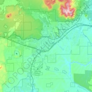
Name: Topografische Karte Flagstaff, Höhe, Relief.
Durchschnittliche Höhe: 2’176 m
Minimale Höhe: 2’008 m
Maximale Höhe: 2’830 m
Spenden
Rüste dich für dein nächstes Abenteuer:
Als Amazon-Partner verdient diese Seite an qualifizierten Käufen, ohne dass Ihnen zusätzliche Kosten entstehen.
Andere topografische Karten
Klicken Sie auf eine Karte, um ihre Topografie, ihre Höhe und ihr Relief anzuzeigen.
Grand Canyon
Vereinigte Staaten von Amerika > Arizona > Coconino County
Das Gebiet um das Tal wird in drei Regionen aufgeteilt: den Südrand (South Rim), der die meisten Besucher anzieht, den im Durchschnitt ca. 300 m höher gelegenen und kühleren Nordrand (North Rim) und die Innere Schlucht (Inner Canyon). Der Südrand des Grand Canyons liegt im Durchschnitt auf 2100 m ü. M.,…
Durchschnittliche Höhe: 1’023 m
Antelope Canyon
Vereinigte Staaten von Amerika > Arizona > Coconino County
Durchschnittliche Höhe: 1’205 m
Flagstaff
Vereinigte Staaten von Amerika > Arizona > Coconino County
Flagstaff liegt auf rund 2100 m Höhe am Südwestrand des Colorado-Plateaus in einer durch Vulkanismus geprägten Landschaft. Nördlich der Stadt erheben sich die San Francisco Peaks mit dem Humphreys Peak, der mit 3852 m den höchsten Punkt in Arizona markiert.
Durchschnittliche Höhe: 2’176 m
Cheops Pyramid
Vereinigte Staaten von Amerika > Arizona > Coconino County
Durchschnittliche Höhe: 1’249 m
Spenden
Rüste dich für dein nächstes Abenteuer:
Als Amazon-Partner verdient diese Seite an qualifizierten Käufen, ohne dass Ihnen zusätzliche Kosten entstehen.
Gray Mountain
Vereinigte Staaten von Amerika > Arizona > Coconino County
Durchschnittliche Höhe: 1’520 m
Grand Canyon
Vereinigte Staaten von Amerika > Arizona > Coconino County
Das Gebiet um das Tal wird in drei Regionen aufgeteilt: den Südrand (South Rim), der die meisten Besucher anzieht, den im Durchschnitt ca. 300 m höher gelegenen und kühleren Nordrand (North Rim) und die Innere Schlucht (Inner Canyon). Der Südrand des Grand Canyons liegt im Durchschnitt auf 2100 m ü. M.,…
Durchschnittliche Höhe: 1’023 m
Antelope Canyon
Vereinigte Staaten von Amerika > Arizona > Coconino County
Durchschnittliche Höhe: 1’202 m
Spenden
Rüste dich für dein nächstes Abenteuer:
Als Amazon-Partner verdient diese Seite an qualifizierten Käufen, ohne dass Ihnen zusätzliche Kosten entstehen.
Flagstaff
Vereinigte Staaten von Amerika > Arizona > Coconino County > Flagstaff
Flagstaff liegt auf rund 2100 m Höhe am Südwestrand des Colorado-Plateaus in einer durch Vulkanismus geprägten Landschaft. Nördlich der Stadt erheben sich die San Francisco Peaks mit dem Humphreys Peak, der mit 3852 m den höchsten Punkt in Arizona markiert.
Durchschnittliche Höhe: 2’230 m