Geolokalisieren

Topografische Karte Mount Saint Helens

Interaktive Karte

Klicken Sie auf die Karte, um die Höhe anzuzeigen.

Über diese Karte

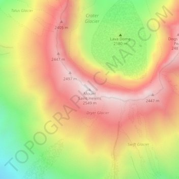
Name: Topografische Karte Mount Saint Helens, Höhe, Relief.

Ort: Mount Saint Helens, Skamania County, Washington, United States (46.19134 -122.19558 46.19144 -122.19548)

Durchschnittliche Höhe: 2’096 m

Minimale Höhe: 1’540 m

Maximale Höhe: 2’533 m

The Mount St. Helens major eruption of May 18, 1980 remains the deadliest and most economically destructive volcanic event in U.S. history. Fifty-seven people were killed; 200 homes, 47 bridges, 15 miles (24 km) of railways, and 185 miles (298 km) of highway were destroyed. A massive debris avalanche, triggered by a magnitude 5.1 earthquake, caused a lateral eruption that reduced the elevation of the mountain's summit from 9,677 ft (2,950 m) to 8,363 ft (2,549 m), leaving a 1 mile (1.6 km) wide horseshoe-shaped crater. The debris avalanche was 0.6 cubic miles (2.5 km3) in volume. The 1980 eruption disrupted terrestrial ecosystems near the volcano. By contrast, aquatic ecosystems in the area greatly benefited from the amounts of ash, allowing life to multiply rapidly. Six years after the eruption, most lakes in the area had returned to their normal state.

Wikipedia (CC-BY-SA 3.0)

Andere topografische Karten

Klicken Sie auf eine Karte, um ihre Topografie, ihre Höhe und ihr Relief anzuzeigen.

Camp Kwoneesum Dam

United States > Washington > Skamania County

Camp Kwoneesum Dam, Skamania County, Washington, United States

Durchschnittliche Höhe: 343 m

Northwoods

United States > Washington > Skamania County

Northwoods, Skamania County, Washington, United States

Durchschnittliche Höhe: 447 m

Underwood

United States > Washington > Skamania County

Underwood, Skamania County, Washington, 98605, United States

Durchschnittliche Höhe: 116 m

Sleeping Beauty

United States > Washington > Skamania County

Sleeping Beauty, Skamania County, Washington, United States

Durchschnittliche Höhe: 1’179 m

Lake Bonneville

United States > Washington > Skamania County

Lake Bonneville, Skamania County, Washington, 98639, United States

Durchschnittliche Höhe: 82 m

Indian Heaven Wilderness

United States > Washington > Skamania County

Indian Heaven Wilderness, Skamania County, Washington, United States

Durchschnittliche Höhe: 1’191 m

Spirit Lake

United States > Washington > Skamania County

Spirit Lake, Skamania County, Washington, United States

Durchschnittliche Höhe: 1’144 m

Lava Dome

United States > Washington > Skamania County

Lava Dome, Skamania County, Washington, United States

Durchschnittliche Höhe: 2’109 m

Skamania

United States > Washington > Skamania County

Skamania, Skamania County, Washington, 97014, United States

Durchschnittliche Höhe: 59 m

North Bonneville

United States > Washington > Skamania County > North Bonneville

North Bonneville, Skamania County, Washington, 98639, United States

Durchschnittliche Höhe: 201 m

Stevenson

United States > Washington > Skamania County

Stevenson, Skamania County, Washington, 98648, United States

Durchschnittliche Höhe: 75 m

Carson

United States > Washington > Skamania County > Carson

Carson, Skamania County, Washington, 98610, United States

Durchschnittliche Höhe: 229 m

Sunset Falls

United States > Washington > Skamania County

Sunset Falls, Skamania County, Washington, United States

Durchschnittliche Höhe: 457 m

Beacon Rock

United States > Washington > Skamania County

Beacon Rock, Skamania County, Washington, 97014, United States

Durchschnittliche Höhe: 93 m

Mount Saint Helens National Volcanic Monument

United States > Washington > Skamania County

Mount Saint Helens National Volcanic Monument, Skamania County, Washington, United States

Durchschnittliche Höhe: 896 m