
Spenden
Rüste dich für dein nächstes Abenteuer:
Als Amazon-Partner verdient diese Seite an qualifizierten Käufen, ohne dass Ihnen zusätzliche Kosten entstehen.
Topografische Karte Bishop
Klicken Sie auf die Karte, um die Höhe anzuzeigen.
Spenden
Rüste dich für dein nächstes Abenteuer:
Als Amazon-Partner verdient diese Seite an qualifizierten Käufen, ohne dass Ihnen zusätzliche Kosten entstehen.
Bishop
Bishop liegt auf 1264 m Höhe am Nordende des Owens Valley. Im Westen erstreckt sich das Gebirge der Sierra Nevada und im Osten die White Mountains. Die Stadt liegt am Bishop Creek, dem größten Zufluss des Owens River.
Spenden
Rüste dich für dein nächstes Abenteuer:
Als Amazon-Partner verdient diese Seite an qualifizierten Käufen, ohne dass Ihnen zusätzliche Kosten entstehen.
Über diese Karte
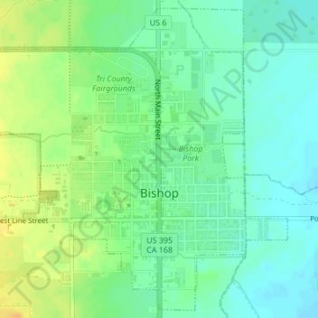
Name: Topografische Karte Bishop, Höhe, Relief.
Durchschnittliche Höhe: 1’265 m
Minimale Höhe: 1’253 m
Maximale Höhe: 1’282 m
Spenden
Rüste dich für dein nächstes Abenteuer:
Als Amazon-Partner verdient diese Seite an qualifizierten Käufen, ohne dass Ihnen zusätzliche Kosten entstehen.
Andere topografische Karten
Klicken Sie auf eine Karte, um ihre Topografie, ihre Höhe und ihr Relief anzuzeigen.
Badwater Basin
Vereinigte Staaten von Amerika > Kalifornien > Inyo County
Badwater ist eine endorheische Senke im Death Valley in Kalifornien und der tiefste Punkt Nordamerikas mit einer Höhe von 85,5 Metern unter dem Meeresspiegel. Badwater ist ein Überbleibsel des vorzeitlichen Sees Lake Manly.
Durchschnittliche Höhe: 152 m