
Spenden
Rüste dich für dein nächstes Abenteuer:
Als Amazon-Partner verdient diese Seite an qualifizierten Käufen, ohne dass Ihnen zusätzliche Kosten entstehen.
Topografische Karte Monument Valley Navajo Tribal Park
Klicken Sie auf die Karte, um die Höhe anzuzeigen.
Spenden
Rüste dich für dein nächstes Abenteuer:
Als Amazon-Partner verdient diese Seite an qualifizierten Käufen, ohne dass Ihnen zusätzliche Kosten entstehen.
Monument Valley Navajo Tribal Park
Das Monument Valley liegt in der Four-Corners-Region, an der Grenze zwischen Arizona und Utah, westlich der Staatsgrenzen zu Colorado und New Mexico in einer Höhe von fast 1900 m und wird bevölkerungsstatistisch in die beiden Schwestergebiete Oljato, Arizona und Oljato, Utah geteilt. Die Temperaturen im Monument Valley variieren zwischen −3 °C im Winter und durchschnittlich 30 °C im Sommer. Der Niederschlag beträgt durchschnittlich 240 mm im Jahr und fällt teilweise als Schnee. Niederschläge, Temperaturunterschiede sowie der Wind haben wesentlich dazu beigetragen, die heutige Landschaft zu formen.
Spenden
Rüste dich für dein nächstes Abenteuer:
Als Amazon-Partner verdient diese Seite an qualifizierten Käufen, ohne dass Ihnen zusätzliche Kosten entstehen.
Über diese Karte
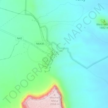
Name: Topografische Karte Monument Valley Navajo Tribal Park, Höhe, Relief.
Durchschnittliche Höhe: 1’675 m
Minimale Höhe: 1’585 m
Maximale Höhe: 2’009 m
Spenden
Rüste dich für dein nächstes Abenteuer:
Als Amazon-Partner verdient diese Seite an qualifizierten Käufen, ohne dass Ihnen zusätzliche Kosten entstehen.
Andere topografische Karten
Klicken Sie auf eine Karte, um ihre Topografie, ihre Höhe und ihr Relief anzuzeigen.
Winslow
Vereinigte Staaten von Amerika > Arizona > Navajo County > Winslow
Durchschnittliche Höhe: 1’495 m