Geolokalisieren

Topografische Karte Rampur

Klicken Sie auf die Karte, um die Höhe anzuzeigen.

Über diese Karte

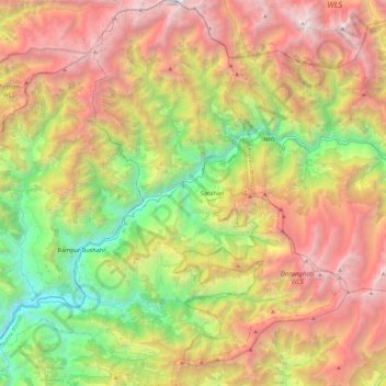
Name: Topografische Karte Rampur, Höhe, Relief.

Ort: Rampur, Shimla, Himachal Pradesh, India (31.30397 77.52160 31.71404 77.96252)

Durchschnittliche Höhe: 2’950 m

Minimale Höhe: 841 m

Maximale Höhe: 5’629 m

Andere topografische Karten

Klicken Sie auf eine Karte, um ihre Topografie, ihre Höhe und ihr Relief anzuzeigen.

Sugga

India > Himachal Pradesh > Rampur

Durchschnittliche Höhe: 2’170 m

Bagiyanda

India > Himachal Pradesh > Bhuntar > Jari

Durchschnittliche Höhe: 1’767 m

Khanola

India > Himachal Pradesh > Rohru > Bhot

Durchschnittliche Höhe: 2’147 m

Dalenu

India > Himachal Pradesh > Renuka

Durchschnittliche Höhe: 1’884 m

Kangra

India > Himachal Pradesh

Durchschnittliche Höhe: 1’665 m

Bhattakufer

India > Himachal Pradesh > Shimla ( Rural )

Durchschnittliche Höhe: 1’951 m

Gajeha

India > Himachal Pradesh > Karsog

Durchschnittliche Höhe: 1’679 m

Kachedh

India > Himachal Pradesh > Chaurah > Nakrod

Durchschnittliche Höhe: 1’515 m

Kao

India > Himachal Pradesh > Brahmaur

Durchschnittliche Höhe: 2’552 m

Kalruhi

India > Himachal Pradesh > Amb

Durchschnittliche Höhe: 510 m

Aloh

India > Himachal Pradesh > Amb

Durchschnittliche Höhe: 677 m

Shimla

India > Himachal Pradesh

Shimla is on the south-western ranges of the Himalayas at 31°37′N 77°06′E / 31.61°N 77.10°E / 31.61; 77.10. It has an average altitude of 2,206 metres (7,238 ft) above mean sea level and extends along a ridge with seven spurs. The city stretches nearly 9.2 kilometres (5+3⁄4 mi) from east to…

Durchschnittliche Höhe: 1’557 m

Pandli

India > Himachal Pradesh > Kotkhai > Kotkhai

Durchschnittliche Höhe: 1’999 m

Gugua

India > Himachal Pradesh > Chaurah > Khushnagri

Durchschnittliche Höhe: 1’914 m

Tosh

India > Himachal Pradesh > Bhuntar

Durchschnittliche Höhe: 2’726 m

Shamshi Thach

India > Himachal Pradesh > Bhuntar

Durchschnittliche Höhe: 4’124 m

Kangra Fort

India > Himachal Pradesh > Kangra > Kaswara

Durchschnittliche Höhe: 674 m

Narghota

India > Himachal Pradesh > Dharamshala > Dharamshala

Durchschnittliche Höhe: 1’108 m

Kachedh

India > Himachal Pradesh > Chaurah > Nakrod

Durchschnittliche Höhe: 1’515 m

Shimla

India > Himachal Pradesh > Shimla (urban)

Shimla is on the south-western ranges of the Himalayas at 31°37′N 77°06′E / 31.61°N 77.10°E / 31.61; 77.10. It has an average altitude of 2,206 metres (7,238 ft) above mean sea level and extends along a ridge with seven spurs. The city stretches nearly 9.2 kilometres (5.7 mi) from east to west.

Durchschnittliche Höhe: 1’557 m

Balana

India > Himachal Pradesh > Sihunta

Durchschnittliche Höhe: 832 m

Bhakra Dam

India > Himachal Pradesh > Bangana > Bilaspur

Durchschnittliche Höhe: 548 m

Teesa

India > Himachal Pradesh > Chaurah

Durchschnittliche Höhe: 1’872 m

Tharola

India > Himachal Pradesh > Kotkhai > Shast

Durchschnittliche Höhe: 2’308 m

Kaza

India > Himachal Pradesh > Spiti

Kaza, also spelled Kaze, Karze, Karzey, is a town and the subdivisional headquarters of the remote Spiti Valley in the western Himalayas in the Lahaul and Spiti district of the northern Indian state of Himachal Pradesh. Spiti is a high altitude or cold desert having close similarities to the neighbouring Tibet…

Durchschnittliche Höhe: 4’161 m

Mehla

India > Himachal Pradesh > Chamba

Durchschnittliche Höhe: 1’469 m

Neugal Rivulet

India > Himachal Pradesh > Palampur

Durchschnittliche Höhe: 1’019 m

Dharamshala

India > Himachal Pradesh > Dharamshala

Dharamshala has an average elevation of 1,457 m (4,780 ft), covering an area of almost 8.51 km2 (3.29 sq mi). Dharamsala is located in the Kangra Valley, in the shadow of the Dhauladhar mountains.

Durchschnittliche Höhe: 1’781 m

Rupin Pass

India > Himachal Pradesh > Dodra Kwar > Jiskon > Matiyam

Durchschnittliche Höhe: 4’564 m

Nauhra

India > Himachal Pradesh > Karsog > banthal

Durchschnittliche Höhe: 1’596 m

Moti Tibba

India > Himachal Pradesh > Dalhousie > Dalhousie

Durchschnittliche Höhe: 1’773 m

Arhal

India > Himachal Pradesh > Rohru

Durchschnittliche Höhe: 2’047 m

Utrala

India > Himachal Pradesh > Baijnath

Durchschnittliche Höhe: 1’517 m

Urang sorrang

India > Himachal Pradesh > Moorang

Durchschnittliche Höhe: 3’755 m

Sejar

India > Himachal Pradesh > Tikar

Durchschnittliche Höhe: 2’110 m

Bhuthi

India > Himachal Pradesh > Karsog > Karsog

Durchschnittliche Höhe: 1’609 m

Keylang

India > Himachal Pradesh > Lahaul

Kyelang is accessible from Manali via the Manali-Leh Highway, a part of NH21. It is located about 71 km (44 mi) north of Manali at an altitude of 3,080 m (10,100 ft) and used to remain cut off from the outside world for six months from late October to mid-May due to heavy snowfall at Rohtang pass until the…

Durchschnittliche Höhe: 3’823 m

Rupin Pass

India > Himachal Pradesh > Dodra Kwar > Jiskon > Matiyam

Durchschnittliche Höhe: 4’564 m

Dhaugi

India > Himachal Pradesh > Sainj

Durchschnittliche Höhe: 2’080 m

Rahi

India > Himachal Pradesh > Bali Chowki > Balichowki

Durchschnittliche Höhe: 1’543 m

Garkhal

India > Himachal Pradesh > Kasauli

Durchschnittliche Höhe: 1’530 m

Galma

India > Himachal Pradesh > Mandi

Durchschnittliche Höhe: 897 m

Jorkanden

India > Himachal Pradesh > Moorang

Durchschnittliche Höhe: 5’506 m

Manali

India > Himachal Pradesh > Manali

Durchschnittliche Höhe: 2’606 m

Kaurik

India > Himachal Pradesh > Spiti

Durchschnittliche Höhe: 3’932 m

Hira

India > Himachal Pradesh > Cheta

Durchschnittliche Höhe: 1’764 m

Kaffota

India > Himachal Pradesh > Kamrau

Durchschnittliche Höhe: 1’425 m

Jabna

India > Himachal Pradesh > Chaupal

Durchschnittliche Höhe: 2’396 m

Kaloha

India > Himachal Pradesh > Rakkar

Durchschnittliche Höhe: 732 m

Panog

India > Himachal Pradesh > Shimla ( Rural ) > Shogi

Durchschnittliche Höhe: 1’631 m

pandar

India > Himachal Pradesh > Nihri

Durchschnittliche Höhe: 2’031 m

Rewalsar

India > Himachal Pradesh > Mandi

Rewalsar is located at an altitude of 1360 m above sea level. It is connected to Mandi by a motorable road and is about 25 km from Mandi. Lying in the Southern Himalayan belt, winters in Rewalsar can be freezing, while summers are generally pleasant.

Durchschnittliche Höhe: 1’283 m

Jarai

India > Himachal Pradesh > Chaupal > Maraug

Durchschnittliche Höhe: 2’348 m

Gumma

India > Himachal Pradesh > Kotkhai

Durchschnittliche Höhe: 1’807 m

Kinnu

India > Himachal Pradesh > Rampur

Durchschnittliche Höhe: 2’423 m

Nagni

India > Himachal Pradesh > Dhira

Durchschnittliche Höhe: 768 m

Baghi

India > Himachal Pradesh > Kotkhai

Durchschnittliche Höhe: 2’576 m

Chakar

India > Himachal Pradesh > Shimla

Durchschnittliche Höhe: 1’796 m

Sarahan

India > Himachal Pradesh > Rampur

Sarahan is located at 31°31′N 77°48′E / 31.52°N 77.80°E / 31.52; 77.80. It has an average elevation of 2,313 metres (7,589 feet).

Durchschnittliche Höhe: 2’204 m

Daranghati WLS

India > Himachal Pradesh > Rampur > Kasha

Durchschnittliche Höhe: 3’565 m

Phancha

India > Himachal Pradesh > Rampur

Durchschnittliche Höhe: 2’472 m

Dhamun

India > Himachal Pradesh > Shimla ( Rural )

Durchschnittliche Höhe: 1’353 m

Chintpurni

India > Himachal Pradesh > Dehra

Durchschnittliche Höhe: 799 m

Racholi

India > Himachal Pradesh > Rampur > Khas Chati

Durchschnittliche Höhe: 1’554 m

Ganvi

India > Himachal Pradesh > Rampur

Durchschnittliche Höhe: 2’012 m

Ghasi

India > Himachal Pradesh > Kotkhai > Kotkhai

Durchschnittliche Höhe: 1’974 m

Khabar

India > Himachal Pradesh > Kumharsain > Nahal

Durchschnittliche Höhe: 1’648 m

Guad

India > Himachal Pradesh > Kullu

Durchschnittliche Höhe: 2’336 m

Pin Valley National Park

India > Himachal Pradesh > Spiti

Durchschnittliche Höhe: 4’903 m

Kasol

India > Himachal Pradesh > Bhuntar

Durchschnittliche Höhe: 2’424 m

Darcha

India > Himachal Pradesh > Lahul

Darcha (elevation 3,360 m or 11,020 ft) is a pair of villages (Darcha Sumdo and Darach Dangma) on the Bhaga River in the Lahaul sub-division in the Lahaul and Spiti district in the Indian state of Himachal Pradesh. It is the northernmost permanent settlement in Himachal Pradesh along the Manali-Leh Highway.…

Durchschnittliche Höhe: 3’702 m

Bhojnagar

India > Himachal Pradesh > Solan

Durchschnittliche Höhe: 1’327 m

Nani

India > Himachal Pradesh > Theog > Matiana

Durchschnittliche Höhe: 2’530 m

Kolhara

India > Himachal Pradesh > Jubbal > Jubbal

Durchschnittliche Höhe: 2’363 m

Fagu

India > Himachal Pradesh > Theog

Durchschnittliche Höhe: 2’223 m

Shahul

India > Himachal Pradesh > Sainj

Durchschnittliche Höhe: 1’648 m

Basantpur

India > Himachal Pradesh > Seoni

Durchschnittliche Höhe: 1’228 m

Nagar

India > Himachal Pradesh > Kullu > Naggar

Durchschnittliche Höhe: 1’930 m

Barnet

India > Himachal Pradesh > Dharamshala > Dharamshala

Durchschnittliche Höhe: 1’426 m

Chawai

India > Himachal Pradesh > Ani

Durchschnittliche Höhe: 1’908 m

Gharoh

India > Himachal Pradesh > Dharamshala

Durchschnittliche Höhe: 1’029 m

Morang

India > Himachal Pradesh > Moorang

Durchschnittliche Höhe: 2’755 m

Baletra

India > Himachal Pradesh > Bhattiyat > Chatoli

Durchschnittliche Höhe: 1’478 m

Kataula

India > Himachal Pradesh > Mandi

Durchschnittliche Höhe: 1’374 m

Dharot

India > Himachal Pradesh > Kumharsain

Durchschnittliche Höhe: 2’126 m

Tiun

India > Himachal Pradesh > Kullu

Durchschnittliche Höhe: 2’723 m

Chailchowk

India > Himachal Pradesh > Chachyot

Durchschnittliche Höhe: 1’307 m

Solan

India > Himachal Pradesh > Solan

Solan is a city in the Indian state of Himachal Pradesh and the district headquarters of Solan district. It is located 45.5 kilometres (28 mi) south of the state capital, Shimla. Solan has an average elevation of 1,550 metres (5,090 ft). The city is situated between Chandigarh (joint capital of Punjab and…

Durchschnittliche Höhe: 1’312 m

Dansa

India > Himachal Pradesh > Rampur

Durchschnittliche Höhe: 2’001 m

Banuri

India > Himachal Pradesh > Palampur

Durchschnittliche Höhe: 1’254 m

Rihana

India > Himachal Pradesh > Karsog > Jeora

Durchschnittliche Höhe: 944 m

Kaupo

India > Himachal Pradesh > Theog > Mehana

Durchschnittliche Höhe: 2’214 m

Matehr

India > Himachal Pradesh > Nagrota Bagwan

Durchschnittliche Höhe: 974 m

matehr

India > Himachal Pradesh > Palampur > Palampur

Durchschnittliche Höhe: 1’208 m

Rohanda

India > Himachal Pradesh > Nihri

Durchschnittliche Höhe: 2’124 m

Preshi

India > Himachal Pradesh > Nihri

Durchschnittliche Höhe: 1’668 m

Boh

India > Himachal Pradesh > Shahpur

Durchschnittliche Höhe: 1’644 m

matehr

India > Himachal Pradesh > Palampur > Palampur

Durchschnittliche Höhe: 1’208 m

jalrehr

India > Himachal Pradesh > Palampur > Banuri

Durchschnittliche Höhe: 1’259 m

Shilli

India > Himachal Pradesh > Arki

Durchschnittliche Höhe: 1’294 m

Rüste dich für dein nächstes Abenteuer:

🎒Wander‑Rucksäcke - Geräumige und leichte Rucksäcke für Tages‑ und Mehrtagestouren
🧹Schuhpflege-Sets - Werterhalt für teure Leder-Wanderschuhe
📦Notrationen & Trekkingnahrung - Leichte, energiereiche Lebensmittel für Touren
🧣Multifunktionstücher - Vielseitiger Schutz für Hals und Kopf beim Wandern
🥾Ausrüstung für leichtes Wandern - Ultraleichte Ausrüstung für schnelle Touren

Als Amazon-Partner verdient diese Seite an qualifizierten Käufen, ohne dass Ihnen zusätzliche Kosten entstehen.