Geolokalisieren

Topografische Karte Rampur

Interaktive Karte

Klicken Sie auf die Karte, um die Höhe anzuzeigen.

Über diese Karte

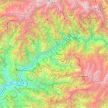
Name: Topografische Karte Rampur, Höhe, Relief.

Ort: Rampur, Shimla, Himachal Pradesh, India (31.30397 77.52160 31.71404 77.96252)

Durchschnittliche Höhe: 2’950 m

Minimale Höhe: 841 m

Maximale Höhe: 5’629 m

Andere topografische Karten

Klicken Sie auf eine Karte, um ihre Topografie, ihre Höhe und ihr Relief anzuzeigen.

Thathar

India > Himachal Pradesh > Sundarnagar > Sundarnagar

Durchschnittliche Höhe: 954 m

Jharoti

India > Himachal Pradesh > Thunag > Janjheli

Durchschnittliche Höhe: 2’270 m

Basantpur

India > Himachal Pradesh > Seoni

Durchschnittliche Höhe: 1’228 m

Shillai

India > Himachal Pradesh > Shalai

Durchschnittliche Höhe: 1’556 m

Shimla

India > Himachal Pradesh > Shimla (urban)

Shimla is on the south-western ranges of the Himalayas at 31°37′N 77°06′E / 31.61°N 77.10°E / 31.61; 77.10. It has an average altitude of 2,206 metres (7,238 ft) above mean sea level and extends along a ridge with seven spurs. The city stretches nearly 9.2 kilometres (5.7 mi) from east to west.

Durchschnittliche Höhe: 1’557 m

Kangti

India > Himachal Pradesh > Kullu > Basag

Durchschnittliche Höhe: 1’677 m

Po

India > Himachal Pradesh > Spiti

Durchschnittliche Höhe: 5’212 m

Kangra

India > Himachal Pradesh

Durchschnittliche Höhe: 1’665 m

Manali

India > Himachal Pradesh > Manali

Durchschnittliche Höhe: 2’606 m

बडूँ

India > Himachal Pradesh > Dera Gopipur

Durchschnittliche Höhe: 511 m

Jarol

India > Himachal Pradesh > Kumharsain

Durchschnittliche Höhe: 2’219 m

Rail

India > Himachal Pradesh > Theog > Bijhalta

Durchschnittliche Höhe: 1’546 m

Kaza

India > Himachal Pradesh > Spiti

Kaza, also spelled Kaze, Karze, Karzey, is a town and the subdivisional headquarters of the remote Spiti Valley in the western Himalayas in the Lahaul and Spiti district of the northern Indian state of Himachal Pradesh. Spiti is a high altitude or cold desert having close similarities to the neighbouring Tibet…

Durchschnittliche Höhe: 4’161 m

Balag

India > Himachal Pradesh > Theog > Bijhalta

Durchschnittliche Höhe: 1’503 m

Sarchu

India > Himachal Pradesh > Lahul

Durchschnittliche Höhe: 5’408 m

Tharoch

India > Himachal Pradesh > Nerua

Durchschnittliche Höhe: 1’840 m

Chebar

India > Himachal Pradesh > Karsog

Durchschnittliche Höhe: 1’353 m

Yunam

India > Himachal Pradesh > Lahul

Durchschnittliche Höhe: 5’514 m

Siyuri

India > Himachal Pradesh > Jogindarnagar > Joginder Nagar

Durchschnittliche Höhe: 1’244 m

Balh

India > Himachal Pradesh > Dharamshala > Dharamshala

Durchschnittliche Höhe: 1’906 m

Khirganga

India > Himachal Pradesh > Bhuntar

Durchschnittliche Höhe: 3’328 m

Chakban

India > Himachal Pradesh > Dharamshala > Khaniara

Durchschnittliche Höhe: 1’532 m

Balag

India > Himachal Pradesh > Sundarnagar

Durchschnittliche Höhe: 976 m

Kheerganga Hot Spring

India > Himachal Pradesh > Bhuntar > Khirganga

Durchschnittliche Höhe: 3’135 m

Panchrukhi

India > Himachal Pradesh > Palampur

Durchschnittliche Höhe: 1’045 m

Solan

India > Himachal Pradesh > Solan

Solan is a city in the Indian state of Himachal Pradesh and the district headquarters of Solan district. It is located 45.5 kilometres (28 mi) south of the state capital, Shimla. Solan has an average elevation of 1,550 metres (5,090 ft). The city is situated between Chandigarh (joint capital of Punjab and…

Durchschnittliche Höhe: 1’312 m

Kembli

India > Himachal Pradesh > Dharamshala > Dharamshala

Durchschnittliche Höhe: 2’113 m

Chelian

India > Himachal Pradesh > Dharamshala

Durchschnittliche Höhe: 1’123 m

Kharota

India > Himachal Pradesh > Dharamshala > Khaniara

Durchschnittliche Höhe: 1’713 m

Leda

India > Himachal Pradesh > Mandi

Durchschnittliche Höhe: 1’335 m

Paundal Bunha

India > Himachal Pradesh > Padhar > Padhar

Durchschnittliche Höhe: 1’414 m

Rait

India > Himachal Pradesh > Shahpur

Durchschnittliche Höhe: 709 m

Sidhbari

India > Himachal Pradesh > Dharamshala

Durchschnittliche Höhe: 1’197 m

Nurpur

India > Himachal Pradesh > Nurpur

Nurpur is located at 32°18′N 75°54′E / 32.3°N 75.9°E / 32.3; 75.9. It has an average elevation of 643 metres (2109 feet).

Durchschnittliche Höhe: 536 m

Khirganga

India > Himachal Pradesh > Bhuntar

Durchschnittliche Höhe: 3’328 m

Sulah

India > Himachal Pradesh > Palampur

Durchschnittliche Höhe: 944 m

Dharamshala

India > Himachal Pradesh > Dharamshala

Dharamshala has an average elevation of 1,457 m (4,780 ft), covering an area of almost 8.51 km2 (3.29 sq mi). Dharamsala is located in the Kangra Valley, in the shadow of the Dhauladhar mountains.

Durchschnittliche Höhe: 1’781 m

Tharot

India > Himachal Pradesh > Shahpur > Chadhi

Durchschnittliche Höhe: 866 m

Parol

India > Himachal Pradesh > Dharamshala

Durchschnittliche Höhe: 907 m

Kotli

India > Himachal Pradesh > Kotli

Kotli Tungal (Kotli) is a small town in Himachal Pradesh, in northern India located along national highway 70 (updated 003) which connects Jalandhar (in Punjab) to Mandi. It is 22 km (14 mi) from the town of Mandi, Kotli is a Sub Division and Tehsil (Sub District) of Mandi District. Kotli and the surrounding…

Durchschnittliche Höhe: 1’194 m

Keylang

India > Himachal Pradesh > Lahul

Kyelang is accessible from Manali via the Manali-Leh Highway, a part of NH21. It is located about 71 km (44 mi) north of Manali at an altitude of 3,080 m (10,100 ft) and used to remain cut off from the outside world for six months from late October to mid-May due to heavy snowfall at Rohtang pass until the…

Durchschnittliche Höhe: 3’823 m

Darcha

India > Himachal Pradesh > Lahul

Darcha (elevation 3,360 m or 11,020 ft) is a pair of villages (Darcha Sumdo and Darach Dangma) on the Bhaga River in the Lahaul sub-division in the Lahaul and Spiti district in the Indian state of Himachal Pradesh. It is the northernmost permanent settlement in Himachal Pradesh along the Manali-Leh Highway.…

Durchschnittliche Höhe: 3’702 m

Dhaula Kuan

India > Himachal Pradesh > Paonta Sahib

Durchschnittliche Höhe: 470 m

Mahog

India > Himachal Pradesh > Theog

Durchschnittliche Höhe: 2’006 m

Jarol

India > Himachal Pradesh > Kumharsain

Durchschnittliche Höhe: 2’219 m

Jagatsukh

India > Himachal Pradesh > Manali

Durchschnittliche Höhe: 2’101 m

Alhilal

India > Himachal Pradesh > Baijnath

Durchschnittliche Höhe: 1’092 m

Tharola

India > Himachal Pradesh > Kotkhai > Shast

Durchschnittliche Höhe: 2’308 m

Salanbari

India > Himachal Pradesh > Palampur > Bhattu

Durchschnittliche Höhe: 1’016 m

Dhauladhar

India > Himachal Pradesh > Holi

Durchschnittliche Höhe: 2’577 m

Sissu

India > Himachal Pradesh > Lahul

Durchschnittliche Höhe: 3’404 m

Kirti

India > Himachal Pradesh > Kumharsain

Durchschnittliche Höhe: 1’407 m

Old Manali

India > Himachal Pradesh > Manali

Durchschnittliche Höhe: 2’290 m

Phatt

India > Himachal Pradesh > Baijnath > Kotli

Durchschnittliche Höhe: 1’569 m

Patalsu Peak

India > Himachal Pradesh > Manali

Durchschnittliche Höhe: 3’752 m

Parwanoo

India > Himachal Pradesh > Kasauli

Durchschnittliche Höhe: 862 m

Nagar

India > Himachal Pradesh > Kullu > Naggar

Durchschnittliche Höhe: 1’930 m

Baga

India > Himachal Pradesh > Darlaghat

Durchschnittliche Höhe: 1’170 m

Bhoi

India > Himachal Pradesh > Dharamshala > Ansohi

Durchschnittliche Höhe: 784 m

Namgial

India > Himachal Pradesh > Poo district

Durchschnittliche Höhe: 3’169 m

Nahan

India > Himachal Pradesh > Nahan

Nahan is located at 30°33′N 77°18′E / 30.55°N 77.3°E / 30.55; 77.3. It has an average elevation of 932 metres.

Durchschnittliche Höhe: 685 m

Chirgoan

India > Himachal Pradesh > Chirgaon

Durchschnittliche Höhe: 2’271 m

Mandri

India > Himachal Pradesh > Seoni

Durchschnittliche Höhe: 1’160 m

Buner

India > Himachal Pradesh > Nagrota Bagwan

Durchschnittliche Höhe: 870 m

Rakhundi Top

India > Himachal Pradesh > Banjar

Durchschnittliche Höhe: 3’095 m

Dehra Gopipur

India > Himachal Pradesh > Dera Gopipur

Dehra Gopipur is located at 31°54′N 76°13′E / 31.90°N 76.22°E / 31.90; 76.22. It has an average elevation of 503 metres (1,650 feet). River Beas also flows past Dera. Pong reservoir (Maharana Pratap reservoir) is also a nearby major structure.

Durchschnittliche Höhe: 478 m

Sissu

India > Himachal Pradesh > Lahul

Durchschnittliche Höhe: 3’404 m

Punanu

India > Himachal Pradesh > Karsog

Durchschnittliche Höhe: 1’631 m

Manali

India > Himachal Pradesh > Manali

Durchschnittliche Höhe: 2’606 m

Kanial

India > Himachal Pradesh > Manali > Siumsa

Durchschnittliche Höhe: 2’323 m

pandar

India > Himachal Pradesh > Nihri

Durchschnittliche Höhe: 2’031 m

Jharoti

India > Himachal Pradesh > Thunag > Janjheli

Durchschnittliche Höhe: 2’270 m

Beas River

India > Himachal Pradesh > Kullu > Badah

Durchschnittliche Höhe: 2’218 m

Kullu

India > Himachal Pradesh > Kullu

Kullu town has an average elevation of 1,278 m (4,193 ft). It lies on the bank of Beas River. A major tributary, Sarvari, (derived from "Shiv-Baardi") leads to the less explored and steeper Lug-valley on the west. On the east of Kullu lies a broad mountainous ridge having the village-temples of Bijli Mahadev,…

Durchschnittliche Höhe: 1’808 m

Auhar

India > Himachal Pradesh > Bhattiyat

Durchschnittliche Höhe: 1’186 m

Silu

India > Himachal Pradesh > Theog > Barharalu

Durchschnittliche Höhe: 2’028 m

Tiwan

India > Himachal Pradesh > Sainj

Durchschnittliche Höhe: 2’662 m

Manali

India > Himachal Pradesh > Manali

Durchschnittliche Höhe: 2’606 m

Billing

India > Himachal Pradesh > Baijnath

Durchschnittliche Höhe: 2’114 m

Passu

India > Himachal Pradesh > Dharamshala

Durchschnittliche Höhe: 944 m

Kandbari

India > Himachal Pradesh > Palampur

Durchschnittliche Höhe: 1’424 m

Manali

India > Himachal Pradesh > Manali

Durchschnittliche Höhe: 2’606 m

Narghota

India > Himachal Pradesh > Dharamshala > Dharamshala

Durchschnittliche Höhe: 1’108 m

Shanan

India > Himachal Pradesh > Shimla

Durchschnittliche Höhe: 2’012 m

Nagadhar

India > Himachal Pradesh > Kumharsain

Durchschnittliche Höhe: 2’386 m

Majothi

India > Himachal Pradesh > Chachyot

Durchschnittliche Höhe: 1’663 m

Darini

India > Himachal Pradesh > Shahpur

Durchschnittliche Höhe: 1’339 m

Bhalyani

India > Himachal Pradesh > Kullu

Durchschnittliche Höhe: 2’050 m

Rekong Peo

India > Himachal Pradesh > Kalpa

Durchschnittliche Höhe: 2’850 m

Bajaura

India > Himachal Pradesh > Bhuntar

Durchschnittliche Höhe: 1’255 m

Koldam Dam

India > Himachal Pradesh > Sundarnagar > Bilaspur > Ropa

Durchschnittliche Höhe: 734 m

Pharal

India > Himachal Pradesh > Kumharsain > Thach

Durchschnittliche Höhe: 1’929 m

Nagwain

India > Himachal Pradesh > Aut

Durchschnittliche Höhe: 1’294 m

Chhurla

India > Himachal Pradesh > Kullu > Badhai

Durchschnittliche Höhe: 1’806 m

Tosh

India > Himachal Pradesh > Bhuntar

Durchschnittliche Höhe: 2’726 m

Tapri

India > Himachal Pradesh > Nichar

Durchschnittliche Höhe: 2’312 m

Dhamola

India > Himachal Pradesh > Thunag > Tir

Durchschnittliche Höhe: 2’385 m

Kullu

India > Himachal Pradesh > Kullu

Kullu town has an average elevation of 1,278 m (4,193 ft). It lies on the bank of Beas River. A major tributary, Sarvari, (derived from "Shiv-Baardi") leads to the less explored and steeper Lug-valley on the west. On the east of Kullu lies a broad mountainous ridge having the village-temples of Bijli Mahadev,…

Durchschnittliche Höhe: 1’808 m

Dharamshala

India > Himachal Pradesh > Dharamshala

The town is located in the Kangra Valley, in the shadow of the Dhauladhar range of the Himalayas at an altitude of 1,457 metres (4,780 ft). References to Dharamshala and its surrounding areas are found in ancient Hindu scriptures such as Rig Veda and Mahabharata. The region was under Mughal influence before it…

Durchschnittliche Höhe: 1’781 m

Sumdo

India > Himachal Pradesh > Spiti

Durchschnittliche Höhe: 3’329 m