
Topografische Karte Pigeon Island
Interaktive Karte
Klicken Sie auf die Karte, um die Höhe anzuzeigen.
Über diese Karte
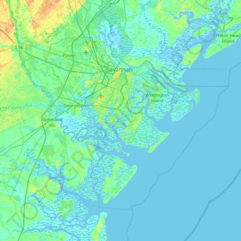
Name: Topografische Karte Pigeon Island, Höhe, Relief.
Ort: Pigeon Island, Chatham County, Georgia, 31411, USA (31.62244 -81.40844 32.26244 -80.76844)
Durchschnittliche Höhe: 4 m
Minimale Höhe: -5 m
Maximale Höhe: 35 m
Andere topografische Karten
Klicken Sie auf eine Karte, um ihre Topografie, ihre Höhe und ihr Relief anzuzeigen.
Alpharetta
USA > Georgia > Alpharetta
Alpharetta, Fulton County, Georgia, USA
Durchschnittliche Höhe: 324 m
Statesboro
USA > Georgia > Statesboro
Statesboro, Bulloch County, Georgia, USA
Durchschnittliche Höhe: 66 m
Chattahoochee Bend State Park
Chattahoochee Bend State Park, Coweta County, Georgia, USA
Durchschnittliche Höhe: 238 m
Orange Springs
USA > Georgia > Orange Springs
Orange Springs, Grady County, Georgia, 31797, USA
Durchschnittliche Höhe: 78 m
Cameron Point
USA > Georgia > Cameron Point
Cameron Point, Hall County, Georgia, 30506:30534, USA
Durchschnittliche Höhe: 339 m
Forbes Lake
USA > Georgia > Saint Louis
Forbes Lake, Dandelion Drive, Saint Louis, Macon County, Georgia, USA
Durchschnittliche Höhe: 126 m
Sandy Springs
USA > Georgia > Sandy Springs
Sandy Springs, Fulton County, Georgia, USA
Durchschnittliche Höhe: 301 m
Hidden Creek
Hidden Creek, Douglas County, Georgia, 30135, USA
Durchschnittliche Höhe: 286 m
Ferrell Crossroads
USA > Georgia > Ferrell Crossroads
Ferrell Crossroads, Early County, Georgia, USA
Durchschnittliche Höhe: 94 m