
Topografische Karte Major Island
Interaktive Karte
Klicken Sie auf die Karte, um die Höhe anzuzeigen.
Über diese Karte
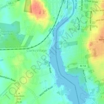
Name: Topografische Karte Major Island, Höhe, Relief.
Ort: Major Island, New London County, Connecticut, USA (41.35966 -71.83946 41.36025 -71.83902)
Durchschnittliche Höhe: 16 m
Minimale Höhe: -2 m
Maximale Höhe: 48 m
Andere topografische Karten
Klicken Sie auf eine Karte, um ihre Topografie, ihre Höhe und ihr Relief anzuzeigen.
Cromwell
USA > Connecticut > Cromwell
Cromwell, Middlesex County, Connecticut, 06480, USA
Durchschnittliche Höhe: 31 m
Wilton
USA > Connecticut > Wilton
Wilton, Fairfield, Connecticut, 06897, USA
Durchschnittliche Höhe: 102 m
Branford Hills
USA > Connecticut > Branford Hills
Branford Hills, New Haven County, Connecticut, 06512, USA
Durchschnittliche Höhe: 12 m
Stamford
USA > Connecticut > Stamford
Stamford, Fairfield, Connecticut, USA
Durchschnittliche Höhe: 48 m
Hartford County
Newington, Hartford County, Connecticut, USA
Durchschnittliche Höhe: 45 m
Milford
USA > Connecticut > Milford
Milford, New Haven County, Connecticut, USA
Durchschnittliche Höhe: 17 m
White Mountain
White Mountain, Middlesex County, Connecticut, 06456, USA
Durchschnittliche Höhe: 59 m
Torrington
USA > Connecticut > Torrington
Torrington, Litchfield County, Connecticut, 06790, USA
Durchschnittliche Höhe: 303 m
Mount Archer
Mount Archer, New London County, Connecticut, 06371:06423, USA
Durchschnittliche Höhe: 69 m