
Topografische Karte Yellowstone Lake
Interaktive Karte
Klicken Sie auf die Karte, um die Höhe anzuzeigen.
Über diese Karte
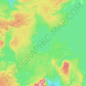
Name: Topografische Karte Yellowstone Lake, Höhe, Relief.
Ort: Yellowstone Lake, Teton County, Wyoming, United States (44.27663 -110.58115 44.56399 -110.20122)
Durchschnittliche Höhe: 2’453 m
Minimale Höhe: 2’270 m
Maximale Höhe: 2’926 m
The lake has been known by various names as depicted on early maps and in journals. Both fur trader David Thompson and explorer William Clark referred to the lake as Yellow Stone. Osborne Russell referred to the lake as Yellow Stone Lake in his 1834 journal. On some William Clark maps, the lake has the name Eustis Lake and the name Sublette's Lake was also used to name the lake in the early 19th century. The name Yellowstone Lake appears formally first in the 1839 maps of the Oregon Territory by U.S. Army topographical engineer, Captain Washington Hood and has remained so since that time.
Andere topografische Karten
Klicken Sie auf eine Karte, um ihre Topografie, ihre Höhe und ihr Relief anzuzeigen.
Grand Teton National Park
United States > Wyoming > Teton County
Grand Teton National Park, Teton County, Wyoming, United States
Durchschnittliche Höhe: 2’409 m
Teton Village
United States > Wyoming > Teton County
Teton Village, Teton County, Wyoming, 83025, United States
Durchschnittliche Höhe: 2’144 m
Pacific Creek
United States > Wyoming > Teton County
Pacific Creek, Teton County, Wyoming, United States
Durchschnittliche Höhe: 2’434 m
Isa Lake
United States > Wyoming > Teton County
Isa Lake, Teton County, Wyoming, United States
Durchschnittliche Höhe: 2’503 m
Rocky Mountains
United States > Wyoming > Teton County
Rocky Mountains, Teton County, Wyoming, United States
Durchschnittliche Höhe: 2’292 m
Jackson
United States > Wyoming > Teton County
Jackson, Teton County, Wyoming, 83002, United States
Durchschnittliche Höhe: 2’043 m
Disappointment Peak
United States > Wyoming > Teton County
Disappointment Peak, Teton County, Wyoming, United States
Durchschnittliche Höhe: 3’255 m
Moran
United States > Wyoming > Teton County > Moran
Moran, Teton County, Wyoming, United States
Durchschnittliche Höhe: 2’088 m
Upper Geyser Basin
United States > Wyoming > Teton County > Upper Geyser Basin
Upper Geyser Basin, Teton County, Wyoming, United States
Durchschnittliche Höhe: 2’295 m
Buck Mountain
United States > Wyoming > Teton County
Buck Mountain, Teton County, Wyoming, United States
Durchschnittliche Höhe: 3’128 m
Grand Teton
United States > Wyoming > Teton County
Grand Teton, Teton County, Wyoming, United States
Durchschnittliche Höhe: 3’330 m