Geolokalisieren

Topografische Karte Anderson County

Interaktive Karte

Klicken Sie auf die Karte, um die Höhe anzuzeigen.

Über diese Karte

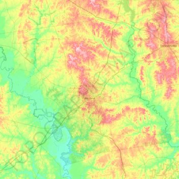
Name: Topografische Karte Anderson County, Höhe, Relief.

Ort: Anderson County, Texas, United States (31.50368 -96.06470 32.08448 -95.25888)

Durchschnittliche Höhe: 117 m

Minimale Höhe: 53 m

Maximale Höhe: 233 m

Andere topografische Karten

Klicken Sie auf eine Karte, um ihre Topografie, ihre Höhe und ihr Relief anzuzeigen.

San Antonio

United States > Texas > Bexar County > San Antonio

Durchschnittliche Höhe: 218 m

Georgetown

United States > Texas > Georgetown

The city is located on the northeastern edge of Texas Hill Country. Portions of Georgetown are located on either side of the Balcones Escarpment, a fault line in which the areas roughly east of IH-35 are flat and characterized by having black, fertile soils of the Blackland Prairie, and the west side of the…

Durchschnittliche Höhe: 219 m

Sierra Blanca

United States > Texas > Hudspeth County

Sierra Blanca is found in Far West Texas, a subdivision of West Texas, and is 4,520 feet (1,380 m) above sea level. The town is part of the Trans-Pecos region within the most mountainous and arid portion of Texas. The town is located in Hudspeth County, which is large and sparsely populated. Sierra Blanca…

Durchschnittliche Höhe: 1’391 m

Mount Selman

United States > Texas > Cherokee County

Durchschnittliche Höhe: 173 m

Parvin

United States > Texas > Denton County > Prosper

Durchschnittliche Höhe: 180 m

Mustang

United States > Texas > Denton County

Durchschnittliche Höhe: 182 m

James Allen Colonia

United States > Texas > Hidalgo County > Palmhurst

Durchschnittliche Höhe: 48 m

Cypress

United States > Texas > Harris County

Durchschnittliche Höhe: 46 m

Placedo

United States > Texas > Victoria County

Durchschnittliche Höhe: 17 m

Pontotoc

United States > Texas > Mason County

Durchschnittliche Höhe: 470 m

Arroyo City

United States > Texas > Cameron County

Durchschnittliche Höhe: 5 m

Barton Creek

United States > Texas > Travis County > Austin

Durchschnittliche Höhe: 155 m

Dabney

United States > Texas > Uvalde County

Durchschnittliche Höhe: 325 m

Whitman

United States > Texas > Washington County

Durchschnittliche Höhe: 79 m

D'Hanis

United States > Texas > Medina County

D'Hanis is at an elevation of 883 feet (269 m) above sea level.

Durchschnittliche Höhe: 273 m

Hunt

United States > Texas > Kerr County

Durchschnittliche Höhe: 572 m

Eleanor Tinsley Park

United States > Texas > Harris County > Houston

Durchschnittliche Höhe: 17 m

Spring

United States > Texas > Harris County

Durchschnittliche Höhe: 35 m

Memorial Park

United States > Texas > El Paso County > El Paso

Durchschnittliche Höhe: 1’167 m

Oletha

United States > Texas > Limestone County

Durchschnittliche Höhe: 133 m

Guadalupe River

United States > Texas > Kerr County > Kerrville

Durchschnittliche Höhe: 510 m

Lavon

United States > Texas > Collin County

Durchschnittliche Höhe: 156 m

Russell Creek Park

United States > Texas > Collin County > Plano

Durchschnittliche Höhe: 227 m

Martinsville

United States > Texas > Nacogdoches County

Durchschnittliche Höhe: 87 m

Joppa

United States > Texas > Dallas County > Dallas

Durchschnittliche Höhe: 126 m

Hern Colonia

United States > Texas > Hidalgo County > Edinburg

Durchschnittliche Höhe: 27 m

Galveston Island

United States > Texas > Galveston County > Galveston

Durchschnittliche Höhe: 2 m

Woodland Hills

United States > Texas > Montgomery County > Conroe

Durchschnittliche Höhe: 99 m

Eldorado Lake

United States > Texas > Bexar County > San Antonio

Durchschnittliche Höhe: 250 m

Canada Verde

United States > Texas > Wilson County

Durchschnittliche Höhe: 137 m

Brock

United States > Texas > Parker County

Durchschnittliche Höhe: 264 m

Burris

United States > Texas > Lubbock County

Durchschnittliche Höhe: 960 m

Olmito

United States > Texas > Cameron County

Durchschnittliche Höhe: 11 m

Buffalo Bayou Park

United States > Texas > Harris County > Houston

Durchschnittliche Höhe: 16 m

Brady Island

United States > Texas > Harris County > Houston

Durchschnittliche Höhe: 9 m

Rio Vista Addition Colonia

United States > Texas > El Paso County > Socorro

Durchschnittliche Höhe: 1’116 m

Sanderson

United States > Texas > Terrell County

Durchschnittliche Höhe: 901 m

La Fuente Colonia

United States > Texas > El Paso County > Socorro

Durchschnittliche Höhe: 1’117 m

Adamsville

United States > Texas > Lampasas County

Durchschnittliche Höhe: 336 m

King Mountain

United States > Texas > Coryell County

Durchschnittliche Höhe: 240 m

Boggy Creek Greenbelt

United States > Texas > Travis County > Austin

Durchschnittliche Höhe: 158 m

Segno

United States > Texas > Polk County

Durchschnittliche Höhe: 60 m

Spring

United States > Texas > Harris County

Durchschnittliche Höhe: 35 m

Bleakwood

United States > Texas > Newton County

Durchschnittliche Höhe: 31 m

Satin

United States > Texas > Falls County

Durchschnittliche Höhe: 115 m

Highland Bayou

United States > Texas > Galveston County > Hitchcock

Durchschnittliche Höhe: 5 m

Deadwood

United States > Texas > Panola County

Durchschnittliche Höhe: 78 m

Kingsland

United States > Texas > Llano County

Durchschnittliche Höhe: 272 m

Terlingua

United States > Texas > Brewster County

Durchschnittliche Höhe: 872 m

Sheerin Junction

United States > Texas > Moore County

Durchschnittliche Höhe: 1’077 m

Nada

United States > Texas > Colorado County

Durchschnittliche Höhe: 46 m

Lasara

United States > Texas > Willacy County

Durchschnittliche Höhe: 15 m

Antioch

United States > Texas > Bastrop County

Durchschnittliche Höhe: 149 m

Paige

United States > Texas > Bastrop County

Durchschnittliche Höhe: 161 m

Colonia del Rio Number 1

United States > Texas > El Paso County > San Elizario

Durchschnittliche Höhe: 1’108 m

Sterling Ridge

United States > Texas > Montgomery County > The Woodlands

Durchschnittliche Höhe: 58 m

Thedford

United States > Texas > Smith County > Lindale

Durchschnittliche Höhe: 155 m

Hacienda Heights

United States > Texas > El Paso County > El Paso

Durchschnittliche Höhe: 1’143 m

Guadalupe River

United States > Texas > Kerr County > Kerrville

Durchschnittliche Höhe: 510 m

Devil’s Sinkhole

United States > Texas > Edwards County > Rocksprings

Durchschnittliche Höhe: 685 m

Nameless

United States > Texas > Travis County > Leander

Durchschnittliche Höhe: 277 m

Alsdorf

United States > Texas > Ellis County

Durchschnittliche Höhe: 119 m

Bushland

United States > Texas > Potter County

Bushland is located at 35°11′31″N 102°03′53″W / 35.19194°N 102.06472°W / 35.19194; -102.06472 (35.1919978, -102.0646392), at an elevation of 3,825 feet. The community is situated along Interstate 40, approximately 14 miles west of Amarillo in southwestern Potter County.

Durchschnittliche Höhe: 1’167 m

Guadalupe River State Park

United States > Texas > Comal County

Durchschnittliche Höhe: 353 m

Briscoe Ranch Dam

United States > Texas > Webb County

Durchschnittliche Höhe: 176 m

Winslow

United States > Texas > Hill County > Hillsboro

Durchschnittliche Höhe: 187 m

Bridwell Park

United States > Texas > Wichita County > Wichita Falls

Durchschnittliche Höhe: 302 m

Big Bend Ranch State Park

United States > Texas > Presidio County

Durchschnittliche Höhe: 1’068 m

Red Bird Addition

United States > Texas > Dallas County > Duncanville

Durchschnittliche Höhe: 221 m

Lane City

United States > Texas > Wharton County

Durchschnittliche Höhe: 27 m

Hunt

United States > Texas > Kerr County

Durchschnittliche Höhe: 572 m

Buchanan Dam

United States > Texas > Llano County

Durchschnittliche Höhe: 327 m

Slipdown Mountain

United States > Texas > Parker County

Durchschnittliche Höhe: 390 m

Algerita

United States > Texas > San Saba County

Durchschnittliche Höhe: 394 m

Briggs

United States > Texas > Burnet County

Briggs lies along U.S. Route 183 and FM 2657, northeast of Burnet. Its elevation is 1,102 feet (336 m), and it is located at 30°53′23″N 97°55′30″W / 30.88972°N 97.92500°W / 30.88972; -97.92500. Although Briggs is unincorporated, it has a post office, with the ZIP code of 78608. The…

Durchschnittliche Höhe: 336 m

Holiday Beach

United States > Texas > Nueces County > Port Aransas

Durchschnittliche Höhe: 2 m

Authon

United States > Texas > Parker County

Durchschnittliche Höhe: 318 m

Rye

United States > Texas > Brazos County

Durchschnittliche Höhe: 87 m

Skidmore

United States > Texas > Bee County

Durchschnittliche Höhe: 49 m

Davisville

United States > Texas > Angelina County > Redland

Durchschnittliche Höhe: 86 m

Etoile

United States > Texas > Nacogdoches County

Durchschnittliche Höhe: 64 m

Cypress Creek

United States > Texas > Harris County > Houston

Durchschnittliche Höhe: 35 m

Guy

United States > Texas > Fort Bend County

Durchschnittliche Höhe: 24 m

Bayview

United States > Texas > Galveston County > Bacliff

Durchschnittliche Höhe: 5 m

Dealey Plaza

United States > Texas > Dallas County > Dallas

Durchschnittliche Höhe: 132 m

Osprey Hill

United States > Texas > Webb County > Laredo

Durchschnittliche Höhe: 138 m

Startzville

United States > Texas > Comal County

Durchschnittliche Höhe: 333 m

McKinney Falls State Park

United States > Texas > Travis County > Austin

Durchschnittliche Höhe: 171 m

San Saba River

United States > Texas > Menard County

Durchschnittliche Höhe: 651 m

Bruceville

United States > Texas > McLennan County > Bruceville-Eddy

Durchschnittliche Höhe: 188 m

Comyn

United States > Texas > Comanche County

Durchschnittliche Höhe: 385 m

Nelsonville

United States > Texas > Austin County

Durchschnittliche Höhe: 87 m

Lassater

United States > Texas > Marion County

Durchschnittliche Höhe: 97 m

Bacliff

United States > Texas > Galveston County

After Hurricane Ike hit Texas in September 2008, Galveston County officials offered a debris removal program to residents in unincorporated areas, including Bacliff. Flooding from hurricane Ike was minimized due in part to Bacliff's relatively high elevation of 16 feet.

Durchschnittliche Höhe: 4 m

Damon Mound

United States > Texas > Brazoria County > Damon

Durchschnittliche Höhe: 28 m

Spring

United States > Texas > Harris County

Durchschnittliche Höhe: 35 m