
Topografische Karte Sosnowiec
Interaktive Karte
Klicken Sie auf die Karte, um die Höhe anzuzeigen.
Über diese Karte
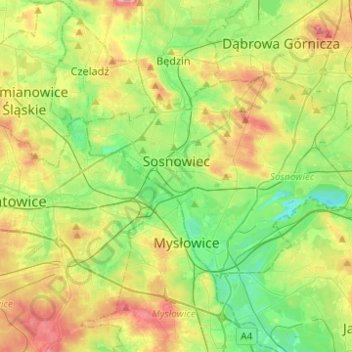
Name: Topografische Karte Sosnowiec, Höhe, Relief.
Durchschnittliche Höhe: 272 m
Minimale Höhe: 225 m
Maximale Höhe: 347 m
For Sosnowiec's 100th birthday, the downtown area was thoroughly rebuilt, to harmonise its architectural layout and give the city a more modern image. In 2004 Sosnowiec authorities and designers were awarded the Grand Prix for the rebuilding of the downtown area in a competition for the best public space in the Śląskie Provinces. This investment had been accompanied by a program designed to improve the esthetic qualities of the city, under which a comprehensive program for unifying the colors of the elevations, and advertisements entitled “rainbow city” were introduced. Among the city districts there are:
Andere topografische Karten
Klicken Sie auf eine Karte, um ihre Topografie, ihre Höhe und ihr Relief anzuzeigen.
Milowice
Poland > Silesian Voivodeship > Sosnowiec
Milowice, Sosnowiec, GZM, Silesian Voivodeship, 41-203, Poland
Durchschnittliche Höhe: 261 m