
Topografische Karte Clarksville
Interaktive Karte
Klicken Sie auf die Karte, um die Höhe anzuzeigen.
Über diese Karte
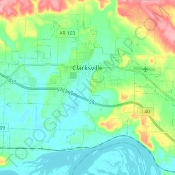
Name: Topografische Karte Clarksville, Höhe, Relief.
Ort: Clarksville, Johnson County, Arkansas, 72830, United States (35.42239 -93.53741 35.49780 -93.41600)
Durchschnittliche Höhe: 137 m
Minimale Höhe: 102 m
Maximale Höhe: 238 m
Spadra was the first county seat of Johnson County, convenient to steamboat lines. However when stagecoach and train transportation became more common, land routes from Little Rock to Fort Smith were directed along higher elevations through Clarksville. As Clarksville grew, it became the de facto location for the county seat circa 1833, probably due to severe flooding at Spadra. Clarksville was established by survey in November 1836 after Johnson County was formed from part of Pope County. The first court session was held in 1837 in a private building.
Andere topografische Karten
Klicken Sie auf eine Karte, um ihre Topografie, ihre Höhe und ihr Relief anzuzeigen.
Coal Hill
United States > Arkansas > Johnson County
Coal Hill, Johnson County, Arkansas, 72832, United States
Durchschnittliche Höhe: 163 m
Montana
United States > Arkansas > Johnson County
Montana, Johnson County, Arkansas, United States
Durchschnittliche Höhe: 125 m
Harmony
United States > Arkansas > Johnson County
Harmony, Johnson County, Arkansas, United States
Durchschnittliche Höhe: 206 m
Knoxville
United States > Arkansas > Johnson County
Knoxville, Johnson County, Arkansas, 72845, United States
Durchschnittliche Höhe: 128 m
Sulphur Springs
United States > Arkansas > Johnson County
Sulphur Springs, Johnson County, Arkansas, United States
Durchschnittliche Höhe: 163 m
Hickeytown
United States > Arkansas > Johnson County
Hickeytown, Johnson County, Arkansas, United States
Durchschnittliche Höhe: 140 m
Gillian Settlement
United States > Arkansas > Johnson County
Gillian Settlement, Johnson County, Arkansas, United States
Durchschnittliche Höhe: 481 m
Oark
United States > Arkansas > Johnson County
Oark, Johnson County, Arkansas, United States
Durchschnittliche Höhe: 389 m
Hagarville
United States > Arkansas > Johnson County
Hagarville, Johnson County, Arkansas, United States
Durchschnittliche Höhe: 173 m
Hartman
United States > Arkansas > Johnson County
Hartman, Johnson County, Arkansas, United States
Durchschnittliche Höhe: 126 m
Lake Dardanelle
United States > Arkansas > Johnson County > Knoxville
Lake Dardanelle, Knoxville, Johnson County, Arkansas, 72845, United States
Durchschnittliche Höhe: 176 m
Lamar
United States > Arkansas > Johnson County
Lamar, Johnson County, Arkansas, United States
Durchschnittliche Höhe: 139 m
Ozone
United States > Arkansas > Johnson County
Ozone, Johnson County, Arkansas, 72854, United States
Durchschnittliche Höhe: 537 m
Strawberry
United States > Arkansas > Johnson County
Strawberry, Johnson County, Arkansas, United States
Durchschnittliche Höhe: 245 m