
Topografische Karte Pacific Palisades
Interaktive Karte
Klicken Sie auf die Karte, um die Höhe anzuzeigen.
Pacific Palisades
Pacific Palisades was formally founded in 1921 by a Methodist organization, and in the years that followed became a refuge for Jewish artists and intellectuals fleeing the Holocaust. The Palisades would later be sought after by celebrities and other high-profile individuals seeking privacy. It is known for its seclusion and for being a close-knit community with a small-town feel, as well as its Mediterranean climate, hilly topography, natural environment, and abundance of parkland and hiking trails, 3-mile (4.8 km) strip of coastline, and for being home to a number of architecturally significant homes.
Über diese Karte
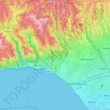
Name: Topografische Karte Pacific Palisades, Höhe, Relief.
Durchschnittliche Höhe: 196 m
Minimale Höhe: -2 m
Maximale Höhe: 653 m
Andere topografische Karten
Klicken Sie auf eine Karte, um ihre Topografie, ihre Höhe und ihr Relief anzuzeigen.
Santa Ynez Reservoir
United States > California > Los Angeles County > Los Angeles
Durchschnittliche Höhe: 307 m
Mission Junction
United States > California > Los Angeles County > Los Angeles
Durchschnittliche Höhe: 103 m
Harbor City
United States > California > Los Angeles County > Los Angeles > Harbor Pines
Durchschnittliche Höhe: 45 m
Los Angeles River
United States > California > Los Angeles County > Los Angeles
Durchschnittliche Höhe: 243 m
Augustus F. Hawkins Natural Park
United States > California > Los Angeles County > Los Angeles
Durchschnittliche Höhe: 55 m
Maguire Gardens
United States > California > Los Angeles County > Los Angeles
Durchschnittliche Höhe: 99 m
Genesee Avenue Park
United States > California > Los Angeles County > Los Angeles
Durchschnittliche Höhe: 33 m
Ballona Creek
United States > California > Los Angeles County > Los Angeles
Durchschnittliche Höhe: 33 m
Mount Lukens
United States > California > Los Angeles County > Los Angeles
It is in the Sunland-Tujunga community within the northeast corner of the city of Los Angeles, above the Crescenta Valley. The summit, at 5,075 feet (1,547 m) in elevation, is the highest point within the city limits. The summit's elevation makes Los Angeles the city with the largest difference between high…
Durchschnittliche Höhe: 1’176 m
Mount Fiji
United States > California > Los Angeles County > Los Angeles
Durchschnittliche Höhe: 191 m
Thenard
United States > California > Los Angeles County > Los Angeles > Thenard
Durchschnittliche Höhe: 8 m