
Topografische Karte Flat Rock
Interaktive Karte
Klicken Sie auf die Karte, um die Höhe anzuzeigen.
Über diese Karte
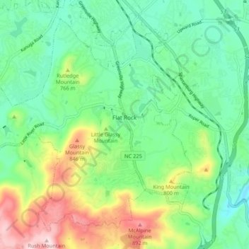
Name: Topografische Karte Flat Rock, Höhe, Relief.
Ort: Flat Rock, Henderson County, North Carolina, United States (35.24084 -82.50104 35.29774 -82.41956)
Durchschnittliche Höhe: 702 m
Minimale Höhe: 589 m
Maximale Höhe: 945 m
Andere topografische Karten
Klicken Sie auf eine Karte, um ihre Topografie, ihre Höhe und ihr Relief anzuzeigen.
Hoopers Creek
United States > North Carolina > Henderson County > Fletcher
Durchschnittliche Höhe: 677 m
Jeter Mountain Terrace
United States > North Carolina > Henderson County
Durchschnittliche Höhe: 793 m
Mills River
United States > North Carolina > Henderson County > Mills River
Durchschnittliche Höhe: 686 m
Hendersonville Reservoir
United States > North Carolina > Henderson County
Durchschnittliche Höhe: 855 m
Wildwood Heights
United States > North Carolina > Henderson County > Laurel Park
Durchschnittliche Höhe: 757 m
Mills River
United States > North Carolina > Henderson County > Mills River > Oak Hill Court
Durchschnittliche Höhe: 644 m
Flat Rock Forest
United States > North Carolina > Henderson County > Flat Rock > Flat Rock Forest
Durchschnittliche Höhe: 681 m
Claremont
United States > North Carolina > Henderson County > Flat Rock > Claremont
Durchschnittliche Höhe: 713 m
Mills River
United States > North Carolina > Henderson County > Mills River > Oak Hill Court
Durchschnittliche Höhe: 633 m