
Topografische Karte Muncie
Interaktive Karte
Klicken Sie auf die Karte, um die Höhe anzuzeigen.
Über diese Karte
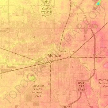
Name: Topografische Karte Muncie, Höhe, Relief.
Ort: Muncie, Delaware County, Indiana, United States (40.14910 -85.45445 40.24070 -85.32067)
Durchschnittliche Höhe: 291 m
Minimale Höhe: 237 m
Maximale Höhe: 313 m
Andere topografische Karten
Klicken Sie auf eine Karte, um ihre Topografie, ihre Höhe und ihr Relief anzuzeigen.
Selma
United States > Indiana > Delaware County
Selma, Delaware County, Indiana, United States
Durchschnittliche Höhe: 304 m
Yorktown
United States > Indiana > Delaware County > Yorktown
Yorktown, Delaware County, Indiana, United States
Durchschnittliche Höhe: 282 m
Eaton
United States > Indiana > Delaware County > Eaton
Eaton, Delaware County, Indiana, 47338, United States
Durchschnittliche Höhe: 279 m