Geolokalisieren

Topografische Karte Southern Peninsula

Interaktive Karte

Klicken Sie auf die Karte, um die Höhe anzuzeigen.

Über diese Karte

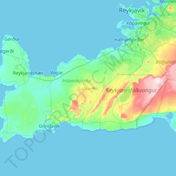
Name: Topografische Karte Southern Peninsula, Höhe, Relief.

Ort: Southern Peninsula, Iceland (63.79989 -22.75378 64.08308 -21.71365)

Durchschnittliche Höhe: 59 m

Minimale Höhe: -3 m

Maximale Höhe: 612 m

Andere topografische Karten

Klicken Sie auf eine Karte, um ihre Topografie, ihre Höhe und ihr Relief anzuzeigen.

Seydisfjordur

Iceland > Múlaþing

A road over Fjarðarheiði mountain pass (elevation 600 m or 2,000 ft) connects Seyðisfjörður to the rest of Iceland; 27 kilometres (17 miles) to the Ring Road and Egilsstaðir. Seyðisfjörður is surrounded by mountains with the most prominent Mt. Bjólfur to the west (1085 m) and Strandartindur (1010 m)…

Durchschnittliche Höhe: 443 m

Karahnjukar

Iceland > Múlaþing

Durchschnittliche Höhe: 621 m

Kirkjufell

Iceland > Grundarfjarðarbær

Durchschnittliche Höhe: 34 m

Urðartindur

Iceland > Árneshreppur

Durchschnittliche Höhe: 109 m

Gullfoss

Iceland > Bláskógabyggð

Durchschnittliche Höhe: 214 m

Kistufell

Iceland > Snæfellsbær

Durchschnittliche Höhe: 456 m

Reykjahlíð

Iceland > Þingeyjarsveit

Durchschnittliche Höhe: 305 m

T2

Iceland > Þingeyjarsveit

Durchschnittliche Höhe: 544 m

Laki

Iceland > Skaftárhreppur

The eruption, also known as the Skaftáreldar [ˈskaftˌauːrˌɛltar̥] ("Skaftá fires") or Síðueldur [ˈsiːðʏˌɛltʏr̥] produced an estimated 14 km3 (18×10^9 cu yd) of basalt lava, and the total volume of tephra emitted was 0.91 km3 (1.2×10^9 cu yd). Lava fountains were estimated to have reached…

Durchschnittliche Höhe: 626 m

Flateyri

Iceland > Ísafjarðarbær

Durchschnittliche Höhe: 90 m

Askja

Iceland > Þingeyjarsveit

Durchschnittliche Höhe: 1’062 m

Herðubreið

Iceland > Þingeyjarsveit

Durchschnittliche Höhe: 1’191 m

Grindavík

Iceland > Grindavíkurbær

Durchschnittliche Höhe: 27 m

Kirkjufell

Iceland > Grundarfjarðarbær

Durchschnittliche Höhe: 34 m

Kirkjufell

Iceland > Grundarfjarðarbær

Durchschnittliche Höhe: 34 m

Seljalandsfoss

Iceland > Rangárþing eystra

Durchschnittliche Höhe: 88 m

Þórsmörk

Iceland > Rangárþing eystra

Durchschnittliche Höhe: 273 m

Skogafoss

Iceland > Rangárþing eystra

Durchschnittliche Höhe: 145 m

Garður

Iceland

Durchschnittliche Höhe: 6 m

Flatey

Iceland > Flatey

Durchschnittliche Höhe: 0 m

Seljalandsfoss

Iceland > Rangárþing eystra

Durchschnittliche Höhe: 88 m

Flatey

Iceland > Flatey

Durchschnittliche Höhe: 0 m

Askja

Iceland > Þingeyjarsveit

Durchschnittliche Höhe: 1’062 m

Hvannadalshnúkur

Iceland > Sveitarfélagið Hornafjörður

Durchschnittliche Höhe: 1’794 m

Keilir

Iceland > Sveitarfélagið Vogar

Durchschnittliche Höhe: 178 m

Vik

Iceland > Mýrdalshreppur

Vík í Mýrdal is the warmest place in Iceland, with an annual mean temperature of 5.3 °C (41.5 °F). Like most of coastal Iceland, Vík í Mýrdal has a subpolar oceanic climate (Koppen Cfc) with cold but not severe winters and cool, short summers. Its winters are among the warmest in Iceland, with an…

Durchschnittliche Höhe: 106 m

Tjarnabyggð

Iceland > Sveitarfélagið Árborg

Durchschnittliche Höhe: 10 m

Mælifell

Iceland > Vopnafjarðarhreppur

Durchschnittliche Höhe: 546 m

Hofsós

Iceland > Skagafjörður

Durchschnittliche Höhe: 13 m

Askja

Iceland > Þingeyjarsveit

Durchschnittliche Höhe: 1’062 m

Reykjanes/Svartsengi volcanic system

Iceland

Durchschnittliche Höhe: 0 m

Ísafjörður

Iceland > Ísafjarðarbær

Durchschnittliche Höhe: 237 m

Vik

Iceland > Mýrdalshreppur

Vík í Mýrdal is the warmest place in Iceland, with an annual mean temperature of 5.3 °C (41.5 °F). Like most of coastal Iceland, Vík í Mýrdal has a subpolar oceanic climate (Koppen Cfc) with cold but not severe winters and cool, short summers. Its winters are among the warmest in Iceland, with an…

Durchschnittliche Höhe: 106 m

Selfoss

Iceland > Sveitarfélagið Árborg

Durchschnittliche Höhe: 48 m

Surtsey

Iceland > Vestmannaeyjabær

Durchschnittliche Höhe: 1 m

Gullfoss Falls

Iceland > Bláskógabyggð

Durchschnittliche Höhe: 221 m

Eyjafjallajökull

Iceland > Rangárþing eystra

Eyjafjallajökull (Icelandic: [ˈeiːjaˌfjat͡ɬaˌjœːkʏt͡ɬ] ; lit. 'glacier of the mountains of the islands'), sometimes referred to by the numeronym E15, is one of the smaller ice caps of Iceland, north of Skógar and west of Mýrdalsjökull. The ice cap covers the caldera of a volcano with a summit…

Durchschnittliche Höhe: 1’459 m

Reykjavik

Iceland > Reykjavik

Durchschnittliche Höhe: 89 m

Geysir

Iceland > Bláskógabyggð

Durchschnittliche Höhe: 116 m

Akureyri

Iceland

Durchschnittliche Höhe: 57 m

Skogafoss

Iceland > Rangárþing eystra

Durchschnittliche Höhe: 145 m

Kerid

Iceland > Grímsnes- og Grafningshreppur

Durchschnittliche Höhe: 71 m

Latrabjarg

Iceland > Vesturbyggð

Durchschnittliche Höhe: 220 m

Hraunfossar

Iceland > Borgarbyggð

Durchschnittliche Höhe: 109 m

Skútustaðagígar

Iceland > Þingeyjarsveit

Durchschnittliche Höhe: 280 m

Thingvellir

Iceland > Bláskógabyggð

Durchschnittliche Höhe: 121 m

Eruption by Fagradalsfjall

Iceland

Durchschnittliche Höhe: 253 m

Suðureyri

Iceland > Ísafjarðarbær

Durchschnittliche Höhe: 144 m

Varmahlíð

Iceland > Skagafjörður

Durchschnittliche Höhe: 46 m

Litli-Hrútur

Iceland > Grindavíkurbær

Durchschnittliche Höhe: 220 m

Mud Pot

Iceland > Sveitarfélagið Ölfus

Durchschnittliche Höhe: 343 m

Grundarfjörður

Iceland > Grundarfjarðarbær

Durchschnittliche Höhe: 181 m

Shield volcano

Iceland > Húnabyggð

Durchschnittliche Höhe: 775 m

Geldingadalir

Iceland > Grindavíkurbær

Durchschnittliche Höhe: 256 m

Hverfjall Crater

Iceland > Skútustaðahreppur

Durchschnittliche Höhe: 330 m

Lambafellshraun

Iceland > Sveitarfélagið Ölfus

Durchschnittliche Höhe: 295 m

Þingvellir National Park

Iceland > Bláskógabyggð

Durchschnittliche Höhe: 316 m

Kirkjufell

Iceland > Grundarfjarðarbær

Durchschnittliche Höhe: 34 m

Sólheimar

Iceland > Grímsnes- og Grafningshreppur

Durchschnittliche Höhe: 74 m

Fludir

Iceland > Hrunamannahreppur

Durchschnittliche Höhe: 95 m

Keflavík

Iceland

Durchschnittliche Höhe: 19 m

Skaftafell

Iceland

Durchschnittliche Höhe: 131 m

Höfn

Iceland > Sveitarfélagið Hornafjörður

Durchschnittliche Höhe: 1 m

Skjaldbreiður

Iceland > Bláskógabyggð

Durchschnittliche Höhe: 910 m

Stjórnarfoss

Iceland > Skaftárhreppur > Kirkjubæjarklaustur

Durchschnittliche Höhe: 87 m

Kerling

Iceland

Durchschnittliche Höhe: 560 m

Akureyri

Iceland

Durchschnittliche Höhe: 51 m

Vestmannaeyjabær

Iceland > Vestmannaeyjabær

Durchschnittliche Höhe: 10 m

Sæból

Iceland

Durchschnittliche Höhe: 98 m

Laugarvatn

Iceland > Laugarvatn

Durchschnittliche Höhe: 171 m

Raufarhöfn

Iceland > Norðurþing

Durchschnittliche Höhe: 13 m

Reykjanesbær

Iceland > Reykjanesbær

Durchschnittliche Höhe: 21 m

Egilsstaðir

Iceland > Egilsstaðir

Durchschnittliche Höhe: 99 m

Esja

Iceland > Kjósarhreppur

Durchschnittliche Höhe: 794 m

Blönduós

Iceland > Húnabyggð

Durchschnittliche Höhe: 51 m

Selfoss

Iceland > Sveitarfélagið Árborg

Durchschnittliche Höhe: 48 m

Dalvík

Iceland > Dalvíkurbyggð

Durchschnittliche Höhe: 182 m

Reykjahlíð

Iceland > Reykjahlíð

Durchschnittliche Höhe: 305 m

Hálá

Iceland

Durchschnittliche Höhe: 303 m

Kollur

Iceland

Durchschnittliche Höhe: 513 m

Eldfell

Iceland > Vestmannaeyjabær

Durchschnittliche Höhe: 45 m

Krafla

Iceland > Skútustaðahreppur

Durchschnittliche Höhe: 622 m

Langhóll

Iceland > Grindavíkurbær

Durchschnittliche Höhe: 244 m

Ný sprunga við Fagradalsfjall

Iceland

Durchschnittliche Höhe: 258 m

Sæból

Iceland > Ísafjarðarbær

Durchschnittliche Höhe: 101 m

Garður

Iceland > Suðurnesjabær > Garður

Durchschnittliche Höhe: 6 m