
Topografische Karte Lac Casabon
Interaktive Karte
Klicken Sie auf die Karte, um die Höhe anzuzeigen.
Über diese Karte
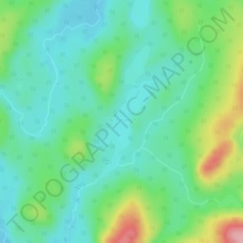
Name: Topografische Karte Lac Casabon, Höhe, Relief.
Durchschnittliche Höhe: 474 m
Minimale Höhe: 434 m
Maximale Höhe: 576 m
Andere topografische Karten
Klicken Sie auf eine Karte, um ihre Topografie, ihre Höhe und ihr Relief anzuzeigen.
Lac-Normand
Canada > Québec > Lac-Normand
Lac-Normand, Mékinac, Mauricie, Québec, Canada
Durchschnittliche Höhe: 398 m
Lac Bréault
Canada > Québec > Lac-Normand
Lac Bréault, Lac-Normand, Mékinac, Mauricie, Québec, Canada
Durchschnittliche Höhe: 403 m
Lac Soixante-Quatre
Canada > Québec > Lac-Normand
Lac Soixante-Quatre, Route forestière 403, Lac-Normand, Mékinac, Mauricie, Québec, Canada
Durchschnittliche Höhe: 386 m
Lac Michel-Denis
Canada > Québec > Lac-Normand
Lac Michel-Denis, Route forestière 403, Lac-Normand, Mékinac, Mauricie, Québec, Canada
Durchschnittliche Höhe: 396 m
Lac Windermere
Canada > Québec > Lac-Normand
Lac Windermere, Route forestière 403, Lac-Normand, Mékinac, Mauricie, Québec, Canada
Durchschnittliche Höhe: 434 m
Lac Babine
Canada > Québec > Lac-Normand
Lac Babine, Route forestière 403, Lac-Normand, Mékinac, Mauricie, Québec, Canada
Durchschnittliche Höhe: 433 m
Lac Mabel
Canada > Québec > Lac-Normand
Lac Mabel, Route forestière 416, Lac-Normand, Mékinac, Mauricie, Québec, Canada
Durchschnittliche Höhe: 484 m