
Topografische Karte Wiesbaden
Interaktive Karte
Klicken Sie auf die Karte, um die Höhe anzuzeigen.
Über diese Karte
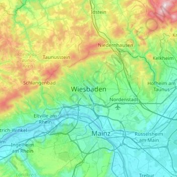
Name: Topografische Karte Wiesbaden, Höhe, Relief.
Ort: Wiesbaden, Hesse, 15183, Germany (49.92204 8.08166 50.24204 8.40166)
Durchschnittliche Höhe: 258 m
Minimale Höhe: 79 m
Maximale Höhe: 880 m
The highest point of the Wiesbaden municipality is located northwest of the city center near the summit of the Hohe Wurzel, with an elevation of 608 metres (1,995 ft) above sea level. The lowest point is the harbour entrance of Schierstein at 83 metres (272 ft) above sea level. The central square (the Schlossplatz, or palace square) is at an elevation of 115 metres (377 ft).