
Topografische Karte Mount Lemmon
Interaktive Karte
Klicken Sie auf die Karte, um die Höhe anzuzeigen.
Über diese Karte
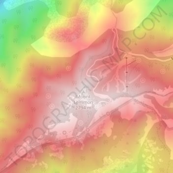
Name: Topografische Karte Mount Lemmon, Höhe, Relief.
Ort: Mount Lemmon, Pima County, Arizona, 85619, USA (32.44308 -110.78848 32.44318 -110.78838)
Durchschnittliche Höhe: 2’514 m
Minimale Höhe: 1’909 m
Maximale Höhe: 2’789 m
Andere topografische Karten
Klicken Sie auf eine Karte, um ihre Topografie, ihre Höhe und ihr Relief anzuzeigen.
Mogollon Rim
Mogollon Rim, Rim Road, Coconino County, Arizona, USA
Durchschnittliche Höhe: 2’108 m
Tonto National Forest
USA > Arizona > Roosevelt Lake Gardens East
Tonto National Forest, NF-424, Roosevelt Lake Gardens East, Gila County, Arizona, 85553, USA
Durchschnittliche Höhe: 1’078 m
Cataract Lake
Cataract Lake, Cataract Road, Williams, Coconino County, Arizona, 86046, USA
Durchschnittliche Höhe: 2’096 m
Kings Canyon
Kings Canyon, Gila County, Arizona, 85502, USA
Durchschnittliche Höhe: 1’122 m
Granite Mountains
Granite Mountains, Pima County, Arizona, USA
Durchschnittliche Höhe: 394 m
Superstition Mountains
Superstition Mountains, Pinal County, Arizona, USA
Durchschnittliche Höhe: 1’125 m
Organ Pipe Cactus National Monument
Organ Pipe Cactus National Monument, Dripping Springs Trail, Pima County, Arizona, USA
Durchschnittliche Höhe: 494 m
Arts Spring
Arts Spring, Trail, Pima County, Arizona, USA
Durchschnittliche Höhe: 2’312 m
Castle Mountains
Castle Mountains, Pima County, Arizona, USA
Durchschnittliche Höhe: 741 m
Grand Canyon National Park
Grand Canyon National Park, Swamp Ridge Road, Coconino County, Arizona, USA
Durchschnittliche Höhe: 1’685 m
Sevenmile Mountains
Sevenmile Mountains, Gila County, Arizona, USA
Durchschnittliche Höhe: 1’511 m
Flowing Wells
Flowing Wells, Tucson, Pima County, Arizona, 85709, USA
Durchschnittliche Höhe: 705 m