
Topografische Karte Round Rock
Interaktive Karte
Klicken Sie auf die Karte, um die Höhe anzuzeigen.
Round Rock
Round Rock sits at an approximate elevation of 735 feet above sea level and spans a diverse terrain shaped by the Balcones Escarpment. This geological fault line divides the city into two distinct landscapes: the eastern side lies on the relatively flat and fertile Blackland Prairie, characterized by deep, clay-rich soils ideal for agriculture. In contrast, the western side features the rugged, limestone-rich topography of the Texas Hill Country, where rolling hills and exposed bedrock are common. This variance in elevation and terrain not only creates a unique visual landscape but also influences local ecosystems and land use across the city.
Über diese Karte
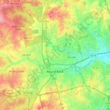
Name: Topografische Karte Round Rock, Höhe, Relief.
Ort: Round Rock, Williamson County, Texas, United States (30.46829 -97.76484 30.59378 -97.59005)
Durchschnittliche Höhe: 242 m
Minimale Höhe: 191 m
Maximale Höhe: 306 m
Andere topografische Karten
Klicken Sie auf eine Karte, um ihre Topografie, ihre Höhe und ihr Relief anzuzeigen.
Soil Conservation Service Site 12 Dam
United States > Texas > Williamson County > Type
Durchschnittliche Höhe: 173 m
Soil Conservation Service Site 12 Dam
United States > Texas > Williamson County > Type
Durchschnittliche Höhe: 173 m
Georgetown
United States > Texas > Williamson County > Georgetown
The city is located on the northeastern edge of Texas Hill Country. Portions of Georgetown are located on either side of the Balcones Escarpment, a fault line in which the areas roughly east of IH-35 are flat and characterized by having black, fertile soils of the Blackland Prairie, and the west side of the…
Durchschnittliche Höhe: 228 m
Cedar Park
United States > Texas > Williamson County > Cedar Park > Cedar Park
Durchschnittliche Höhe: 292 m
Round Rock
United States > Texas > Williamson County > Round Rock
The city straddles the Balcones Escarpment, a fault line in which the areas roughly east of Interstate 35 are flat and characterized by having black, fertile soils of the Blackland Prairie, and the west side of the Escarpment, which consists mostly of hilly, karst-like terrain with little topsoil and higher…
Durchschnittliche Höhe: 236 m