
Topografische Karte Cape Cod
Interaktive Karte
Klicken Sie auf die Karte, um die Höhe anzuzeigen.
Cape Cod
Cape Cod is a distinctive peninsula characterized by its low, gently sloping terrain that extends 65 miles into the Atlantic Ocean. The landscape consists primarily of sandy soils, dunes, and wetlands, with the highest point at Pine Hill reaching 306 feet. The region is dotted with freshwater ponds and bordered by expansive salt marshes and barrier beaches, which give the area its unique, shifting shoreline. The Cape’s varied topography is heavily influenced by glacial deposits and coastal processes, which shape its irregular and picturesque coastal contours.
Über diese Karte
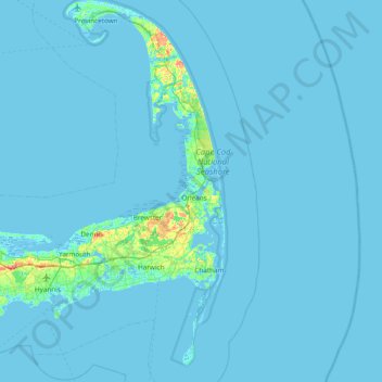
Name: Topografische Karte Cape Cod, Höhe, Relief.
Ort: Cape Cod, Barnstable County, Massachusetts, United States (41.51497 -70.68798 42.08253 -69.92900)
Durchschnittliche Höhe: 2 m
Minimale Höhe: -6 m
Maximale Höhe: 56 m
Andere topografische Karten
Klicken Sie auf eine Karte, um ihre Topografie, ihre Höhe und ihr Relief anzuzeigen.
Cobbs Village
United States > Massachusetts > Barnstable County > Barnstable
Durchschnittliche Höhe: 9 m
Campground Landing
United States > Massachusetts > Barnstable County > Eastham
Durchschnittliche Höhe: 6 m
Opeechee Heights Beach
United States > Massachusetts > Barnstable County > Barnstable > Centerville
Durchschnittliche Höhe: 14 m
South Brewster
United States > Massachusetts > Barnstable County > Brewster
Durchschnittliche Höhe: 26 m
Craigville
United States > Massachusetts > Barnstable County > Centerville
Durchschnittliche Höhe: 6 m
South Yarmouth
United States > Massachusetts > Barnstable County > Yarmouth
Durchschnittliche Höhe: 6 m
West Barnstable
United States > Massachusetts > Barnstable County > West Barnstable
Durchschnittliche Höhe: 15 m
Washburn Island
United States > Massachusetts > Barnstable County > Falmouth > Menauhant
Durchschnittliche Höhe: 1 m
North Eastham
United States > Massachusetts > Barnstable County > Eastham
Durchschnittliche Höhe: 10 m
East Falmouth
United States > Massachusetts > Barnstable County > Falmouth
Durchschnittliche Höhe: 7 m
Yarmouth Port
United States > Massachusetts > Barnstable County > Yarmouth
Durchschnittliche Höhe: 11 m
West Yarmouth
United States > Massachusetts > Barnstable County > Yarmouth
Durchschnittliche Höhe: 4 m
Dennis Port
United States > Massachusetts > Barnstable County > Dennis > Dennis Port
Durchschnittliche Höhe: 3 m
Bournedale
United States > Massachusetts > Barnstable County > Bourne > Bournedale
Durchschnittliche Höhe: 29 m
Barnstable
United States > Massachusetts > Barnstable County > Barnstable > Barnstable
Durchschnittliche Höhe: 10 m
North Harwich
United States > Massachusetts > Barnstable County > Harwich
Durchschnittliche Höhe: 11 m
Pleasant Lake
United States > Massachusetts > Barnstable County > Harwich
Durchschnittliche Höhe: 17 m