
Topografische Karte Riverton
Interaktive Karte
Klicken Sie auf die Karte, um die Höhe anzuzeigen.
Über diese Karte
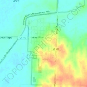
Name: Topografische Karte Riverton, Höhe, Relief.
Ort: Riverton, Fremont County, Iowa, United States (40.67597 -95.57479 40.69424 -95.56246)
Durchschnittliche Höhe: 292 m
Minimale Höhe: 276 m
Maximale Höhe: 323 m
Andere topografische Karten
Klicken Sie auf eine Karte, um ihre Topografie, ihre Höhe und ihr Relief anzuzeigen.
Randolph
United States > Iowa > Fremont County
Randolph, Fremont County, Iowa, United States
Durchschnittliche Höhe: 295 m
McPaul
United States > Iowa > Fremont County
McPaul, Fremont County, Iowa, 51654, United States
Durchschnittliche Höhe: 285 m
Percival
United States > Iowa > Fremont County
Percival, Fremont County, Iowa, 51648, United States
Durchschnittliche Höhe: 283 m
Imogene
United States > Iowa > Fremont County
Imogene, Fremont County, Iowa, United States
Durchschnittliche Höhe: 333 m
Anderson
United States > Iowa > Fremont County
Anderson, Fremont County, Iowa, 51652, United States
Durchschnittliche Höhe: 302 m
Bartlett
United States > Iowa > Fremont County
Bartlett, Fremont County, Iowa, 51654, United States
Durchschnittliche Höhe: 288 m
Tabor
United States > Iowa > Fremont County
Tabor, Fremont County, Iowa, 51653, United States
Durchschnittliche Höhe: 363 m
Hamburg
United States > Iowa > Fremont County
Hamburg, Fremont County, Iowa, United States
Durchschnittliche Höhe: 285 m
Thurman
United States > Iowa > Fremont County
Thurman, Fremont County, Iowa, United States
Durchschnittliche Höhe: 311 m
Sidney
United States > Iowa > Fremont County
Sidney, Fremont County, Iowa, United States
Durchschnittliche Höhe: 339 m
Farragut
United States > Iowa > Fremont County
Farragut, Fremont County, Iowa, 51639, United States
Durchschnittliche Höhe: 292 m