
Topografische Karte Daisy Hill
Interaktive Karte
Klicken Sie auf die Karte, um die Höhe anzuzeigen.
Über diese Karte
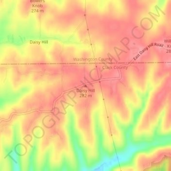
Name: Topografische Karte Daisy Hill, Höhe, Relief.
Ort: Daisy Hill, Clark County, Indiana, USA (38.49918 -85.93002 38.49928 -85.92992)
Durchschnittliche Höhe: 264 m
Minimale Höhe: 205 m
Maximale Höhe: 291 m
Andere topografische Karten
Klicken Sie auf eine Karte, um ihre Topografie, ihre Höhe und ihr Relief anzuzeigen.
Brown’s Ridge
USA > Indiana > Beverly Shores
Brown’s Ridge, Beverly Shores, Porter County, Indiana, 46301, USA
Durchschnittliche Höhe: 183 m
New Frankfort
USA > Indiana > New Frankfort
New Frankfort, Scott County, Indiana, 74710, USA
Durchschnittliche Höhe: 190 m
Huntington
USA > Indiana > Huntington
Huntington, Huntington County, Indiana, 46750, USA
Durchschnittliche Höhe: 238 m
Mound Haven
USA > Indiana > Mound Haven
Mound Haven, Franklin County, Indiana, 47012, USA
Durchschnittliche Höhe: 231 m
Woodville Hills
USA > Indiana > Woodville Hills
Woodville Hills, Monroe County, Indiana, USA
Durchschnittliche Höhe: 196 m
Mount Bentley
USA > Indiana > Dune Acres
Mount Bentley, Dune Acres, Porter County, Indiana, USA
Durchschnittliche Höhe: 183 m