
Spenden
Rüste dich für dein nächstes Abenteuer:
Als Amazon-Partner verdient diese Seite an qualifizierten Käufen, ohne dass Ihnen zusätzliche Kosten entstehen.
Topografische Karte Meridian Peak
Klicken Sie auf die Karte, um die Höhe anzuzeigen.
Spenden
Rüste dich für dein nächstes Abenteuer:
Als Amazon-Partner verdient diese Seite an qualifizierten Käufen, ohne dass Ihnen zusätzliche Kosten entstehen.
Meridian Peak
Meridian Peak can be found at the southern end of Elliot Ridge Trail. It can be reached by ascending several hiking trails into the Gore Range. Surprise Lake Trail goes south for 2.6 miles to Surprise Lake, then the Gore Range Trail continues west for 1.9 miles to a junction with the Upper Cataract Lake and Mirror Lake Trail. Mirror Lake is 6.5 miles beyond the junction, at an elevation of 10,560 feet. The Elliot Ridge Trail is 3.2 miles from Mirror Lake. The summit of Meridian Peak is another 1.2 south from the junction with the Elliot Ridge Trail.
Spenden
Rüste dich für dein nächstes Abenteuer:
Als Amazon-Partner verdient diese Seite an qualifizierten Käufen, ohne dass Ihnen zusätzliche Kosten entstehen.
Über diese Karte
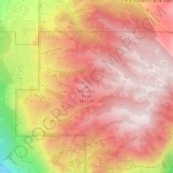
Name: Topografische Karte Meridian Peak, Höhe, Relief.
Durchschnittliche Höhe: 1’698 m
Minimale Höhe: 1’295 m
Maximale Höhe: 1’884 m
Spenden
Rüste dich für dein nächstes Abenteuer:
Als Amazon-Partner verdient diese Seite an qualifizierten Käufen, ohne dass Ihnen zusätzliche Kosten entstehen.
Andere topografische Karten
Klicken Sie auf eine Karte, um ihre Topografie, ihre Höhe und ihr Relief anzuzeigen.
Jordan River OHV/ Modelport State Park
United States > Utah > Salt Lake County > Salt Lake City
Durchschnittliche Höhe: 1’286 m