
Topografische Karte Mount Sopris
Interaktive Karte
Klicken Sie auf die Karte, um die Höhe anzuzeigen.
Über diese Karte
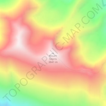
Name: Topografische Karte Mount Sopris, Höhe, Relief.
Ort: Mount Sopris, Pitkin County, Colorado, United States (39.26116 -107.16481 39.26126 -107.16471)
Durchschnittliche Höhe: 3’543 m
Minimale Höhe: 2’990 m
Maximale Höhe: 3’943 m
Andere topografische Karten
Klicken Sie auf eine Karte, um ihre Topografie, ihre Höhe und ihr Relief anzuzeigen.
Aspen
United States > Colorado > Pitkin County
Aspen, Pitkin County, Colorado, United States
Durchschnittliche Höhe: 2’568 m
Snowmass Village
United States > Colorado > Pitkin County
Snowmass Village, Pitkin County, Colorado, 81615, United States
Durchschnittliche Höhe: 2’675 m
Maroon Bells
United States > Colorado > Pitkin County
Maroon Bells, Pitkin County, Colorado, United States
Durchschnittliche Höhe: 3’691 m
Maroon Lake
United States > Colorado > Pitkin County
Maroon Lake, Pitkin County, Colorado, United States
Durchschnittliche Höhe: 3’240 m
Snowmass
United States > Colorado > Pitkin County
Snowmass, Pitkin County, Colorado, 81654, United States
Durchschnittliche Höhe: 2’322 m