
Topografische Karte Amble
Interaktive Karte
Klicken Sie auf die Karte, um die Höhe anzuzeigen.
Über diese Karte
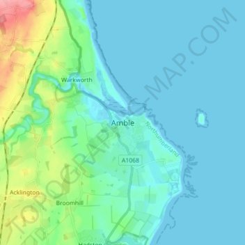
Name: Topografische Karte Amble, Höhe, Relief.
Durchschnittliche Höhe: 15 m
Minimale Höhe: -2 m
Maximale Höhe: 85 m
Samuel Lewis reported a township population of 247 in 1831. By the seventh edition of his Topographical Dictionary of England, which was published in 1848, this figure had risen to 724. The population was reported as being 1,040 in 1851. The 1871 census recorded a population of 1,233, spread among 233 houses.