
Topografische Karte Patel Nagar
Interaktive Karte
Klicken Sie auf die Karte, um die Höhe anzuzeigen.
Über diese Karte
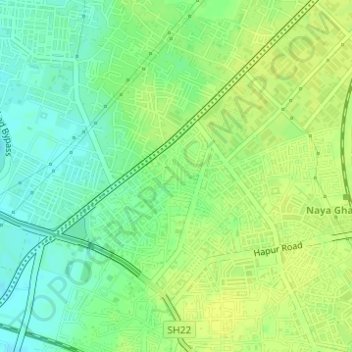
Name: Topografische Karte Patel Nagar, Höhe, Relief.
Ort: Patel Nagar, Ghaziabad, Uttar Pradesh, 201001, India (28.66602 77.41291 28.68602 77.43291)
Durchschnittliche Höhe: 212 m
Minimale Höhe: 202 m
Maximale Höhe: 218 m
Andere topografische Karten
Klicken Sie auf eine Karte, um ihre Topografie, ihre Höhe und ihr Relief anzuzeigen.
Indirapuram
India > Uttar Pradesh > Ghaziabad
Indirapuram, Ghaziabad, Uttar Pradesh, 201001, India
Durchschnittliche Höhe: 204 m
B Block Park Ramprastha Colony
India > Uttar Pradesh > Ghaziabad
B Block Park Ramprastha Colony, Chander Nagar, Kaushambi, Ghaziabad, Uttar Pradesh, 201001, India
Durchschnittliche Höhe: 206 m
Teacher Colony
India > Uttar Pradesh > Ghaziabad
Teacher Colony, Ghaziabad, Uttar Pradesh, 201001, India
Durchschnittliche Höhe: 208 m
JATWARA
India > Uttar Pradesh > Ghaziabad
JATWARA, Ghaziabad, Uttar Pradesh, 201001, India
Durchschnittliche Höhe: 215 m