
Topografische Karte Hartford
Interaktive Karte
Klicken Sie auf die Karte, um die Höhe anzuzeigen.
Über diese Karte
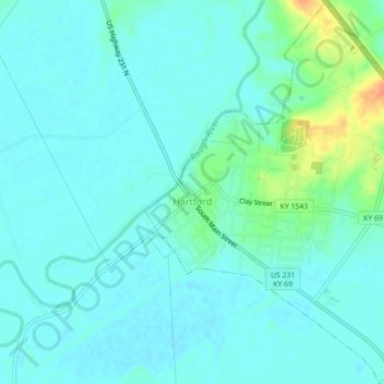
Name: Topografische Karte Hartford, Höhe, Relief.
Ort: Hartford, Ohio County, Kentucky, United States (37.43446 -86.91460 37.46950 -86.87671)
Durchschnittliche Höhe: 123 m
Minimale Höhe: 115 m
Maximale Höhe: 155 m
Several elements of the Downtown Hartford Historic District, including the courthouse, jail and main block of the Hartford City Hall, remain virtually intact on the exterior. As in most downtowns, however, storefronts have suffered the greatest changes. Fortunately, most of the upper elevations of these buildings have been well preserved so that the district's streetscape retains its historic character. Despite alterations, the district remains a visually distinct entity due to the extensively renovated older buildings and new construction that define its edges.
Andere topografische Karten
Klicken Sie auf eine Karte, um ihre Topografie, ihre Höhe und ihr Relief anzuzeigen.
No Creek
United States > Kentucky > Ohio County
No Creek, Ohio County, Kentucky, United States
Durchschnittliche Höhe: 129 m
Olaton
United States > Kentucky > Ohio County
Olaton, Ohio County, Kentucky, 42361, United States
Durchschnittliche Höhe: 157 m
Fordsville
United States > Kentucky > Ohio County > Fordsville
Fordsville, Ohio County, Kentucky, United States
Durchschnittliche Höhe: 163 m