
Spenden
Rüste dich für dein nächstes Abenteuer:
Als Amazon-Partner verdient diese Seite an qualifizierten Käufen, ohne dass Ihnen zusätzliche Kosten entstehen.
Topografische Karte Yorkwood
Klicken Sie auf die Karte, um die Höhe anzuzeigen.
Spenden
Rüste dich für dein nächstes Abenteuer:
Als Amazon-Partner verdient diese Seite an qualifizierten Käufen, ohne dass Ihnen zusätzliche Kosten entstehen.
Über diese Karte
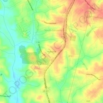
Name: Topografische Karte Yorkwood, Höhe, Relief.
Durchschnittliche Höhe: 225 m
Minimale Höhe: 195 m
Maximale Höhe: 251 m
Spenden
Rüste dich für dein nächstes Abenteuer:
Als Amazon-Partner verdient diese Seite an qualifizierten Käufen, ohne dass Ihnen zusätzliche Kosten entstehen.
Andere topografische Karten
Klicken Sie auf eine Karte, um ihre Topografie, ihre Höhe und ihr Relief anzuzeigen.
Spencer Mountain
United States > North Carolina > Gaston County
The town is located at the base of Spencer Mountain, a 1,250-foot (380 m) summit to the south. The town is sited along the South Fork Catawba River at an elevation of 679 feet (207 m).
Durchschnittliche Höhe: 223 m
Cherryville
United States > North Carolina > Gaston County
Cherryville is located in Cherryville Township at an elevation of 1,007 feet (307 m). According to the United States Census Bureau, the city covers a total area of 5.50 square miles (14.25 km2), of which 5.49 square miles (14.22 km2) is land and 0.012 square miles (0.03 km2), or 0.21%, is water. The small…
Durchschnittliche Höhe: 277 m
Spenden
Rüste dich für dein nächstes Abenteuer:
Als Amazon-Partner verdient diese Seite an qualifizierten Käufen, ohne dass Ihnen zusätzliche Kosten entstehen.
Mountain Island Lake
United States > North Carolina > Gaston County > Mount Holly
Mountain Island Lake is a lake northwest of Charlotte, North Carolina created in 1924 to coincide with the building of Mountain Island Hydroelectric Station. It is named after the mountain which appears as an island in the lake, and the surrounding area is identified by the lake's name. The shape of the lake…
Durchschnittliche Höhe: 216 m
Bessemer City
United States > North Carolina > Gaston County
According to the United States Census Bureau, the city has a total area of 4.8 square miles (12.5 km2), of which 4.8 square miles (12.4 km2) is land and 0.039 square miles (0.1 km2), or 0.78%, is water. The elevation at city hall is 904 feet (276 m) above sea level.
Durchschnittliche Höhe: 258 m
Spenden
Rüste dich für dein nächstes Abenteuer:
Als Amazon-Partner verdient diese Seite an qualifizierten Käufen, ohne dass Ihnen zusätzliche Kosten entstehen.
Cherryville
United States > North Carolina > Gaston County
Cherryville is located in Cherryville Township at 35°22′52″N 81°22′45″W / 35.38111°N 81.37917°W / 35.38111; -81.37917 (35.381169, -81.379168) at an elevation of 1,007 feet (307 m). According to the United States Census Bureau, the city covers a total area of 5.50 square miles (14.25 km2),…
Durchschnittliche Höhe: 277 m
Mount Holly
United States > North Carolina > Gaston County > Mount Holly
Durchschnittliche Höhe: 208 m
Spenden
Rüste dich für dein nächstes Abenteuer:
Als Amazon-Partner verdient diese Seite an qualifizierten Käufen, ohne dass Ihnen zusätzliche Kosten entstehen.