
Topografische Karte Moses Kotane Ward 6
Interaktive Karte
Klicken Sie auf die Karte, um die Höhe anzuzeigen.
Über diese Karte
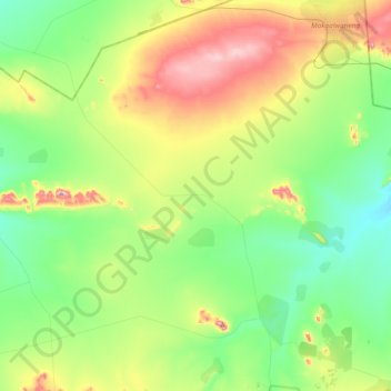
Name: Topografische Karte Moses Kotane Ward 6, Höhe, Relief.
Durchschnittliche Höhe: 1’105 m
Minimale Höhe: 1’003 m
Maximale Höhe: 1’324 m
Andere topografische Karten
Klicken Sie auf eine Karte, um ihre Topografie, ihre Höhe und ihr Relief anzuzeigen.
Moses Kotane Local Municipality
South Africa > North West > Moses Kotane Local Municipality
Moses Kotane Local Municipality, Bojanala Platinum District Municipality, North West, 0314, South Africa
Durchschnittliche Höhe: 1’084 m