
Topografische Karte Marysville
Interaktive Karte
Klicken Sie auf die Karte, um die Höhe anzuzeigen.
Über diese Karte
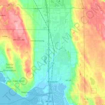
Name: Topografische Karte Marysville, Höhe, Relief.
Ort: Marysville, Snohomish County, Washington, United States (48.01984 -122.28651 48.16329 -122.10961)
Durchschnittliche Höhe: 72 m
Minimale Höhe: -3 m
Maximale Höhe: 201 m
The city's topography varies from the low-lying downtown, located along the banks of Ebey Slough 5 feet (1.5 m) above sea level, rising to 160 feet (49 m) near Smokey Point and over 465 feet (142 m) in the eastern highlands. Marysville sits in the watershed of two major creeks, Quilceda Creek and Allen Creek, and approximately 70 minor streams that flow into Ebey Slough and Snohomish River. During the early 20th century, repeated controlled flooding and other engineering works in the Snohomish River delta contributed to the replenishment of the area's fertile silty soil for use in farming.
Andere topografische Karten
Klicken Sie auf eine Karte, um ihre Topografie, ihre Höhe und ihr Relief anzuzeigen.
Everett
United States > Washington > Snohomish County
Everett, Snohomish County, Washington, United States
Durchschnittliche Höhe: 66 m
Lynnwood
United States > Washington > Snohomish County
Lynnwood, Snohomish County, Washington, 98037, United States
Durchschnittliche Höhe: 121 m
Granite Falls
United States > Washington > Snohomish County
Granite Falls, Snohomish County, Washington, United States
Durchschnittliche Höhe: 120 m
Mill Creek
United States > Washington > Snohomish County
Mill Creek, Snohomish County, Washington, United States
Durchschnittliche Höhe: 130 m
Mukilteo
United States > Washington > Snohomish County
Mukilteo, Snohomish County, Washington, 98275, United States
Durchschnittliche Höhe: 89 m
Everett
United States > Washington > Snohomish County > Everett
Everett, Snohomish County, Washington, 98120, United States
Durchschnittliche Höhe: 67 m