
Topografische Karte Cluj-Napoca
Interaktive Karte
Klicken Sie auf die Karte, um die Höhe anzuzeigen.
Über diese Karte
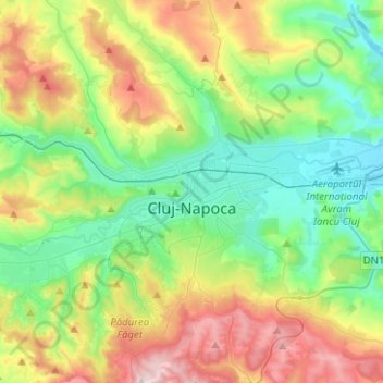
Name: Topografische Karte Cluj-Napoca, Höhe, Relief.
Ort: Cluj-Napoca, Cluj Metropolitan Area, Cluj, Romania (46.68997 23.49924 46.86183 23.71833)
Durchschnittliche Höhe: 480 m
Minimale Höhe: 307 m
Maximale Höhe: 829 m
A wide variety of flora grow in the Cluj-Napoca Botanical Garden; some animals have also found refuge there. The city has a number of other parks, of which the largest is the Central Park. This park was founded during the 19th century and includes an artificial lake with an island, as well as the largest casino in the city, Chios. Other notable parks in the city are the Iuliu Hațieganu Park of the Babeș-Bolyai University, which features some sport facilities, the Hașdeu Park, within the eponymous student housing district, the high-elevation Cetățuia, and the Opera Park, behind the building of the Cluj-Napoca Romanian Opera.
Andere topografische Karten
Klicken Sie auf eine Karte, um ihre Topografie, ihre Höhe und ihr Relief anzuzeigen.
Lunca Vișagului
Lunca Vișagului, Poieni, Cluj, 407474, Romania
Durchschnittliche Höhe: 898 m
Muntele Cacovei
Muntele Cacovei, Băișoara, Cluj, 407071, Romania
Durchschnittliche Höhe: 1’193 m
Muntele Băișorii
Muntele Băișorii, Băișoara, Cluj, 407068, Romania
Durchschnittliche Höhe: 1’115 m
Câmpia Turzii
Romania > Cluj > Câmpia Turzii
Câmpia Turzii, Cluj, 405100, Romania
Durchschnittliche Höhe: 329 m